
The Cuillin is a range of rocky mountains located on the Isle of Skye in Scotland. The main Cuillin ridge is also known as the Black Cuillin to distinguish it from the Red Cuillin, which lie to the east of Glen Sligachan.

The Cairngorms are a mountain range in the eastern Highlands of Scotland closely associated with the mountain Cairn Gorm. The Cairngorms became part of Scotland's second national park on 1 September 2003. Although the Cairngorms give their name to, and are at the heart of, the Cairngorms National Park, they only form one part of the national park, alongside other hill ranges such as the Angus Glens and the Monadhliath, and lower areas like Strathspey.

The Grampian Mountains are one of the three major mountain ranges in Scotland, occupying a considerable portion of the Scottish Highlands in northern Scotland. The other major mountain ranges in Scotland are the Northwest Highlands and the Southern Uplands. The Grampian range extends southwest to northeast between the Highland Boundary Fault and the Great Glen, occupying almost half of the land area of Scotland and including the Cairngorms and the Lochaber hills. The range includes many of the highest mountains in the British Isles, including Ben Nevis and Ben Macdui.

Lochnagar or Beinn Chìochan is a mountain in the Grampians of Scotland, located about five miles south of the River Dee near Balmoral. It is a popular hill with hillwalkers, and is a noted venue for summer and winter climbing.

Ben Lawers is the highest mountain in the southern part of the Scottish Highlands. It lies to the north of Loch Tay, and is the highest point of a long ridge that includes seven Munros. It is the highest peak in Perthshire, and is the tenth highest Munro in Scotland. Ben Lawers was long thought to be over 4,000 feet (1,219.2 m) in height; accurate measurement in the 1870s showed it to be some 17 feet (5.2 m) short of this figure.

Lugnaquilla, at 925 metres (3,035 ft), is the 11th–highest peak in Ireland on the Arderin list, and 13th–highest on the Vandeleur-Lynam list, and the highest Irish mountain outside of Kerry. Lugnaquilla is the highest point in Wicklow, and in the province of Leinster. Lugnaquilla is in the Wicklow Mountains, and overlooks the Glen of Imaal to the west and Glenmalure to the east.

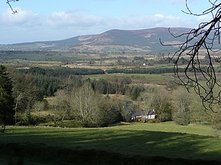
Comrie is a village and parish in the southern Highlands of Scotland, towards the western end of the Strathearn district of Perth and Kinross, 7 mi (11 km) west of Crieff. Comrie is a historic conservation village in a national scenic area along the river Earn. Its position on the Highland Boundary Fault explains why it has more earth tremors than anywhere else in Britain. The parish is twinned with Carleton Place, Ontario, Canada.
Ben Vorlich is a mountain located in the southern part of the Highlands of Scotland. Due to its prominence when seen from the lower ground of the Central Belt, Ben Vorlich is one of the most commonly seen of Munros, Scotland's peaks of 3000ft height or above. It lies in an area of land bounded to the north by Loch Earn, and to the west by Loch Lubnaig. The town of Callander lies to the south.

Scotland is the most mountainous country in the United Kingdom. Scotland's mountain ranges can be divided in a roughly north to south direction into: the Scottish Highlands, the Central Belt and the Southern Uplands, the latter two primarily belonging to the Scottish Lowlands. The highlands eponymously contains the country's main mountain ranges, but many hills and mountains are to be found south of these as well. The below lists are not exhaustive; there are countless subranges throughout the country.

Baurtregaum at 851 metres (2,792 ft), is the 13th–highest peak in Ireland on the Arderin scale, and the 18th–highest peak on the Vandeleur-Lynam scale. Baurtregaum is situated at the centre of the massif of the Slieve Mish Mountains in the Dingle Peninsula in Kerry, Ireland, and is the tallest mountain of the Slieve Mish range, with a number of major subsidiary summits.

Caherconree at 835 metres (2,740 ft), is the 20th–highest peak in Ireland on the Arderin scale, and the 27th–highest peak on the Vandeleur-Lynam scale. Caherconree is the 2nd-highest mountain in the Slieve Mish Mountains in the Dingle Peninsula in Kerry, Ireland, and one of its southerly spurs is the site of an ancient stone promontory fort, which is a protected National Monument.
Lobawn at 636 metres (2,087 ft), is the 182nd–highest peak in Ireland on the Arderin scale, and the 219th–highest peak on the Vandeleur-Lynam scale. Lobawn has a flat boggy summit plateau with a "war department" concrete post to mark the top. Lobawn lies in the west section of the Wicklow Mountains, in Wicklow, Ireland, and has a subsidiary summit called Sugarloaf 552 metres (1,811 ft). Both Lobawn and the Sugarloaf border the Glen of Imaal, and their summits lie close to the actual boundaries of the Glen of Imaal Military Artillery Firing Range.

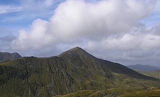
Cnoc an Chuillinn, at 958 metres (3,143 ft), is the sixth-highest peak in Ireland on the Arderin list and the seventh-highest peak in Ireland on the Vandeleur-Lynam list. The name is sometimes incorrectly anglicised to Knockacullion, which is a name used for peaks and townlands in other parts of Ireland. Cnoc an Chuillinn is part of the MacGillycuddy's Reeks range in County Kerry.

Brassel Mountain at 575 metres (1,886 ft), is the 261-st highest peak in Ireland, on the Arderin scale. It is part of the MacGillycuddy's Reeks range in County Kerry. Brassel Mountain is the south-east spur of the larger neighbouring peaks, Cnoc an Chuillinn 958 metres (3,143 ft), and Cnoc an Chuillinn East Top 926 metres (3,038 ft). Because of its positioning away from the main ridge of the Reeks, and away from the glens used to access the Reeks, Brassel is less frequently climbed, but can be used as an exit, or entry point to the main ridge.

Glen Boughton is a locality in the Cairns Region, Queensland, Australia. In 2016 census, Glen Boughton had a population of 28.

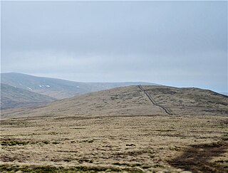
Uamh Bheag is a hill in the Glen Artney Hills range immediately south of the Highland Boundary Fault, part of the Central Lowlands of Scotland. The highest hill of the range, the summit is twin-topped; the lower east top has a trig point. Until 2017, it was not certain which hill was higher, and subsequently which was the Donald and Graham. That year, a survey was conducted which proved the west top to be approximately 2.4m higher. The true summit is currently marked with a cairn and a face carved out of a wooden fencepost, extending from it. It is normally ascended with neighbouring Beinn nan Eun from Glen Artney itself.
Tarmangie Hill is a hill in the Ochil Hills range, part of the Central Lowlands in Scotland. It is one of two Ochil Donalds to lie on the Clackmannanshire-Perth and Kinross border - the other being Blairdenon Hill. It is often climbed as part of a round from Glen Sherup.
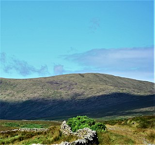
Coran of Portmark is a hill in the Rhinns of Kells, a sub-range of the Galloway Hills range, part of the Southern Uplands of Scotland. The most northerly Donald of the range, it is climbed from a number of directions; most commonly from Garryhorn near Carsphairn, often the first hill of a full traverse of the ridge. An old settlement to the west lends its name to the hill.
