
Ben Lui is a mountain in the southern Highlands of Scotland, at the head of Glen Fyne. It has five well-defined ridges radiating out from the summit. Four corries lie between the ridges; including Coire Gaothaich which lies on the northeast side of the mountain.
Bidean nam Bian, lying to the south of Glen Coe, Highland, Scotland, is the highest point in the former county of Argyll. It is a complex mountain, with many ridges and subsidiary peaks, one of which, Stob Coire Sgreamhach, is classified as a separate Munro.
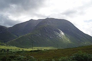
Beinn Dearg is a mountain in the Inverlael area of the Highlands of Scotland. It is most frequently climbed by following the River Lael up Gleann na Sguaib. Starting from near the head of Loch Broom, a path follows the glen to a bealach, which is about a kilometre north of the summit. From this bealach, the neighbouring peaks of Con a' Mheall and Meall na Ceapraichean may also be climbed. Eididh nan Clach Geala, which lies about 3 km north of Beinn Dearg, is also added in to complete a round of 4 Munros.

Beinn Challuim is a Scottish mountain located in the very northern part of the Loch Lomond and the Trossachs National Park six kilometres east northeast of the village of Tyndrum in the Stirling Council area. The mountain stands in the Forest of Mamlorn, an ancient deer forest in Breadalbane.
Creag Mhòr is a Scottish mountain which stands in the ancient Forest of Mamlorn deer forest, it is located ten kilometres north east of Tyndrum on the border between the Perth and Kinross and Stirling council areas.

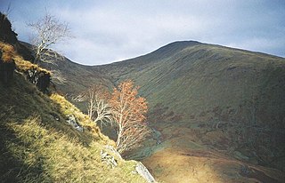
Meall Glas is a mountain situated in the southern highlands of Scotland. It stands on the northern border of the Loch Lomond and the Trossachs National Park, 8.5 kilometres north east of Crianlarich.

Meall nan Tarmachan is a mountain in the Southern Highlands of Scotland near Killin just west of Ben Lawers. It is often climbed as part of the Tarmachan ridge, the other peaks of which are Meall Garbh, Beinn nan Eachan and Creag na Caillach ; these three peaks are Tops rather than Munros, and lie to the south-west of Meall nan Tarmachan.

Beinn Lair is a mountain in the Northwest Highlands, Scotland. It lies in the Letterewe estate on the northeastern shore of Loch Maree in Wester Ross.
{{Infobox mountain | name = Sgurr nan Conbhairean | photo = Sgùrr nan Conbhairean seen from Carn Ghluasaid - geograph.org.uk - 1598776.jpg | photo_caption = Sgurr nan Conbhairean | elevation_m = 1,109 | elevation_ref = | prominence_m = 382 | prominence_ref = | listing = Munro, Marilyn | translation = | language = | pronunciation = | location = Inverness-shire, Scotland | range = [[Northwest Highds]138] | grid_ref_UK = NH129911 | topo = OS Landranger 34 | easiest_route = }}

Beinn nan Aighenan is a mountain in the Grampian Mountains of Scotland. It lies in Argyll and Bute, north of the village of Taynuilt.
Sgurr Dubh is a mountain in the Northwest Highlands, Scotland. It lies southwest of the village of Kinlochewe in Wester Ross.
Beinn Eunaich is a mountain in the Grampian Mountains of Scotland, located north of the village of Dalmally in Argyll and Bute.

Beinn Talaidh is a peak on the Isle of Mull, Scotland, located in the mountainous centre of the Island.

Beinn Iutharn Mhor is a mountain in the Grampian Mountains of Scotland. It lies north of Glen Shee on the Aberdeenshire and Perthshire border.

Beinn Mhic-Mhonaidh is a mountain in the Grampian Mountains of Scotland, west of Glen Orchy in Argyll and Bute.
Beinn Mhic Chasgaig is a mountain in the Grampian Mountains of Scotland. It lies near the head of Glen Etive in Highland.

Beinn nan Eun is a mountain in the Northwest Highlands of Scotland. It is located in Easter Ross, several miles northwest of Dingwall.

Beinn Loinne is a mountain in the Northwest Highlands of Scotland. It rises above the southern shore of Loch Cluanie in Inverness-shire.

Beinn nan Caorach is a mountain in the Northwest Highlands of Scotland, It is located near the village of Corran in Lochalsh.

Beinn Dhorain is a mountain in the Northwest Highlands. It lies in Sutherland in the far north of Scotland, west of the village of Helmsdale.A rounded sandstone peak, it rises steeply above Glen Loth.
