
The Brienzer Rothorn is a mountain of the Emmental Alps, in Switzerland. With an elevation of 2,350 metres (7,710 ft) above sea level, the Brienzer Rothorn is the highest summit of the range. To its west lies the Tannhorn, whilst to its east are Arnihaaggen, Höch Gumme and the Brünig Pass. On its south side it overlooks Lake Brienz, whilst to the north it looks out over the Waldemme valley.
The Lopper Road Tunnel is a tunnel in central Switzerland. The tunnel connects Hergiswil in the canton of Nidwalden with Alpnach in the canton of Obwalden, and forms part of the A8 motorway. The tunnel was opened in 1984, and is 1,590 metres (5,220 ft) long. The tunnel has two lanes, and there is no central reservation. The tunnel runs under the Lopper, a shoulder of Mount Pilatus which extends into Lake Lucerne.

Matt is a village, and former municipality, in the municipality of Glarus Süd and canton of Glarus in Switzerland. Matt lies in the valley of the Sernf river, and consists of the village of Matt itself, and the mountain hamlet of Weissenberge.
Cavaglia is a hamlet on the western flank of the Val Poschiavo in the canton of Graubünden, Switzerland. It lies at 1,703 metres (5,587 ft) above sea level, and is in the municipality of Poschiavo, some 4.7 kilometres (2.9 mi) north-west of the village of the same name. Because of the 700 metres (2,300 ft) of altitude difference between the two villages, the distance between them by road is 11 kilometres (6.8 mi) and the train journey takes 25 minutes. In 2005, Cavaglia's permanent population was 24.
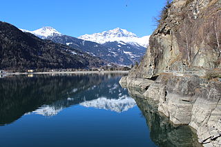
Lago di Poschiavo is a natural lake in the Val di Poschiavo in the Swiss canton of Graubünden.

Monte Ceneri is a mountain pass in the canton of Ticino in Switzerland. It connects the Magadino Plain and the Vedeggio Valley across the Lugano Prealps at an elevation of 554 metres (1,818 ft) above sea level. It provides the most direct route between the cities of Bellinzona and Lugano. Despite its name, Monte Ceneri is the lowest point on the crest between Monte Tamaro and the Camoghè.

The Schynige Platte is a small mountain ridge and a viewpoint in the Bernese Highlands and belongs to the Schwarzhorn group. The mountain range consists of three peaks: Gumihorn, Tuba, and the closest summit next to the viewpoint, Geiss. The viewpoint lies at an altitude of about 2,000 metres (7,000 ft), at the western end of a prominent ridge of the Schwarzhorn group, which separates the valley of the Schwarze Lütschine from Lake Brienz.

Fiescheralp is a locality in the canton of Valais, Switzerland, situated above Fiesch at an elevation of 2,212 metres (7,257 ft) above sea level. It is the highest of the three car-free resorts lying on the southern slopes of the Eggishorn range, the two other being Riederalp and Bettmeralp to the west. Fiescheralp itself lies on a small plateau, approximately 200 metres above the tree line. Administratively, it belongs to the municipality of Fiesch, the border with the municipality of Lax running just west of the resort.

The Selbsanft is a mountain massif in the Glarus Alps, overlooking the village of Linthal in the canton of Glarus. The Selbsanft is a large mountain massif consisting of several summits of which the highest is named Hideri Schibe. The massif is a buttress of the Bifertenstock and forms, along with Schiben, the ridge that separates the valleys of the Sand (west) and Limmernsee (east). A small glacier lies east of the summit.

The Faulhorn is a mountain of the Bernese Alps, located between Lake Brienz and Grindelwald in the Bernese Oberland. The summit is 2,681 metres (8,796 ft) high and can be reached by several trails.
Piz Cancian is a mountain in the Bernina Range of the Alps, located on the border between Italy and the Switzerland. The summit has an elevation of 3,103 metres (10,180 ft) above sea level.

The Gross Lohner, is a limestone mountain of the Bernese Alps, located between Adelboden and Kandersteg in the Bernese Oberland. The main summit has an elevation of 3,048.7 metres (10,002 ft) above sea level and is distinguished by the name Vorder Lohner. The mountain features several other peaks, from east to west:

Cologna is a village in the Val Poschiavo in the canton of Graubünden, Switzerland. It lies at 1,090 metres (3,580 ft) above sea level and is in the municipality of Poschiavo, some 1.5 kilometres (0.93 mi) south-east of the village of the same name.

San Carlo is a village in the Val Poschiavo in the canton of Graubünden, Switzerland. It lies at 1,092 metres (3,583 ft) above sea level and is in the municipality of Poschiavo, some 2 kilometres (1.2 mi) north of the village of the same name.
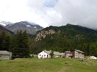
Sfazù is a hamlet in the upper part of the Val Poschiavo in the canton of Graubünden, Switzerland. It lies at 1,622 metres (5,322 ft) above sea level at the point where the Val da Camp enters the Val Poschiavo. It is on the southern approach to the Bernina Pass, and is in the municipality of Poschiavo, some 7.5 kilometres (4.7 mi) north of the village of the same name. Because of the 600 metres (2,000 ft) of altitude difference between the two villages, the distance between them by road is 9 kilometres (5.6 mi), using Hauptstrasse 29 that passes close by Sfazù.
Steg-Hohtenn is a municipality in the district of Raron in the canton of Valais in Switzerland. The municipality comprises the villages of Steg and Hohtenn.

Weisstannen is a village located in the canton of St. Gallen, Switzerland. It lies in the municipality of Mels, south-west of Sargans.
Linthal Braunwaldbahn railway station is a railway station in the municipality of Glarus Süd in the Swiss canton of Glarus. It is situated on the Weesen to Linthal railway line in the valley of the Linth river, some 500 metres (1,600 ft) short of the terminus of the line at Linthal station in the village of Linthal. The station opened in 1982 in order to provide a convenient interchange with the Braunwaldbahn funicular to the car-free resort of Braunwald on the mountain above.

Rigi Kaltbad is a resort in the Swiss Alps, located in the canton of Lucerne. The resort sits on a sunny terrace at an elevation of 1,433 metres (4,701 ft), overlooking Lake Lucerne above Weggis in Central Switzerland. The locality is part of the municipality of Weggis.

The Schynige Platte Alpine Garden is a botanical garden located at an altitude of about 2,000 metres (7,000 ft), near the summit of the Schynige Platte mountain in the Bernese Oberland region of Switzerland. It specialises in research into the high altitude flora of Switzerland, and has a display of over 600 species of plants native to the Swiss Alps. The garden is run by the Schynige Platte Alpine Garden Society, working closely with the Botanical Garden of Bern and the Institute for Plant Sciences at the University of Bern.


