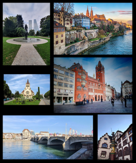
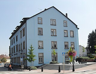
Basel is a city in northwestern Switzerland on the river Rhine. Basel is Switzerland's third-most-populous city with about 175,000 inhabitants. The official language of Basel is German, but the main spoken language is the local Basel German dialect.

The geography of Switzerland encompasses the geographical features of Switzerland, a mountainous and landlocked country located in Western and Central Europe. Switzerland's natural landscape is marked by its numerous lakes and mountains. It is surrounded by 5 countries: Austria and Liechtenstein to the east, France to the west, Italy to the south and Germany to the north. Switzerland has a maximum north–south length of 220 kilometres (140 mi) and an east–west length of about 350 kilometres (220 mi).

Basel-Landschaft or Basel-Country, informally known as Baselland or Baselbiet, is one of the 26 cantons forming the Swiss Confederation. It is composed of five districts and its capital city is Liestal. It is traditionally considered a "half-canton", the other half being Basel-Stadt, its urban counterpart.

Basel-Stadt or Basel-City is one of the 26 cantons forming the Swiss Confederation. It is composed of three municipalities with Basel as the capital. It is traditionally considered a "half-canton", the other half being Basel-Landschaft, its rural counterpart.

The Jura Mountains are a sub-alpine mountain range a short distance north of the Western Alps and mainly demarcate a long part of the French–Swiss border. While the Jura range proper is located in France and Switzerland, the range continues as the Table Jura northeastwards through northern Switzerland and Germany.
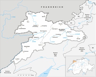
The Republic and Canton of Jura, less formally the Canton of Jura or Canton Jura, is the newest of the 26 Swiss cantons, located in the northwestern part of Switzerland. The capital is Delémont. It shares borders with the canton of Basel-Landschaft, the canton of Bern, the canton of Neuchatel, the canton of Solothurn, and the French régions of Bourgogne-Franche-Comté and Grand Est.

The canton of Solothurn or canton of Soleure is a canton of Switzerland. It is located in the northwest of Switzerland. The capital is Solothurn.
The Belchen Tunnel is a motorway tunnel in Switzerland, and forms part of the A2 motorway from Basel to Chiasso. It links Eptingen in the canton of Basel-Country with Hägendorf in the Canton of Solothurn. The tunnel was opened in 1966, and is 3,180 metres (10,430 ft) long.

The Rauracian Republic was a short-lived French occupation zone that included parts of modern Switzerland around the Jura mountains. It was created from the northern portion of the Prince-Bishopric of Basel, which was part of the Holy Roman Empire.
The Grand Ballon or Great Belchen is the highest mountain of the Vosges, located 25 kilometres (16 mi) northwest of Mulhouse, France. It is also the highest point of the Grand-Est French region.
Belchenflue Pass is a mountain pass to use only by hikers in the Jura Mountains between the cantons of Basel-Country and Solothurn. Nearestby access by car is on the Chilchzimmersattel. Actually the pass does not have a distinct name. It is the signpost just nearby the dead-end hiking trail that has Belchenflue written on.
Passwang Pass is a high mountain pass in the Jura Mountains in the canton of Solothurn in Switzerland.
Hégenheim is a commune in the Haut-Rhin department in Alsace in north-eastern France. It is adjacent to the Swiss town of Allschwil, and is part of the Basel urban area.
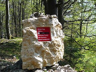
The Hinteri Egg is a mountain of the Jura, located south of Reigoldswil in the Swiss canton of Basel-Landschaft, close to the border with the canton of Solothurn.

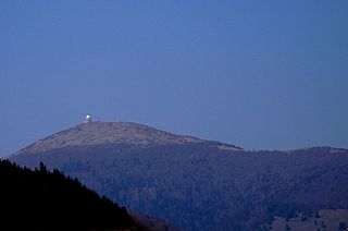
The Belchen, 1,414 metres (4,639 ft), or Black Forest Belchen is the fourth-highest summit of the Black Forest after Feldberg, Seebuck and Herzogenhorn. The municipalities of Münstertal, Schönenberg and Kleines Wiesental meet on the summit dome of Belchen which is located in the southwest German state of Baden-Württemberg.

The German-speaking part of Switzerland comprises about 65 percent of Switzerland.
The Ruchen is a mountain of the Jura, located on the border between the Swiss cantons of Basel-Landschaft and Solothurn. It lies between Langenbruck and Eptingen. The Ruchen is the easternmost summit above 1,100 metres in the Jura Mountains. East of the Ruchen is the Belchenflue.

The Petit Ballon or Little Belchen, is, at 1272m, one of the highest peaks of the Vosges Mountains in the department of Haut-Rhin, Alsace in France, about 5 km away from the village of Wasserbourg. The Rothenbrunnen mountain hut is 500m below. A car park is a further 500m away.

The border between the modern states of Germany and Switzerland extends to 362 kilometres (225 mi), mostly following the High Rhine between Lake Constance and Basel.

The Belchen System refers to five mountains with the name Belchen around the tripoint of Germany, France and Switzerland that may have been used by the Celts as a solar calendar. The term is an extension of the Belchen Triangle. The mountains are:


