Belchenflue Pass (el. 1055 m.) is a mountain pass to use only by hikers in the Jura Mountains between the cantons of Basel-Country and Solothurn. Nearestby access by car is on the Chilchzimmersattel. Actually the pass does not have a distinct name. It is the signpost just nearby the dead-end hiking trail that has Belchenflue written on.
The mountain is also called Bölchen by locals. The name came originally from Celtic from the sun god Belenus. The namegiving nearby peak (el. 1099 m.) was an important marker for the tribal calendar establishing the seasons. Along with the peak of the same name in Alsace (Alsatian Belchen) and Black Forest (Black Forest Belchen), it allowed the establishment of the winter and summer solstice.
As is the case with much of the Jura range, the cliffs are formed of hard oolithic limestone, which has been exposed as the softer stone above it has eroded.
The pass forms the divide between the watershed of the Aare in the south and the Ergolz in the north. Both flow into the Rhine. To the east are the Challhöchi and Unterer Hauenstein passes.
Mount Whitney is the highest mountain in the contiguous United States and the Sierra Nevada, with an elevation of 14,505 feet (4,421 m). It is in East–Central California, on the boundary between California's Inyo and Tulare counties, 84.6 miles (136.2 km) west-northwest of North America's lowest point, Badwater Basin in Death Valley National Park, at 282 ft (86 m) below sea level. The mountain's west slope is in Sequoia National Park and the summit is the southern terminus of the John Muir Trail, which runs 211.9 mi (341.0 km) from Happy Isles in Yosemite Valley. The eastern slopes are in Inyo National Forest in Inyo County.
At 1,493 metres (4,898 ft) the Feldberg in the Black Forest is the highest mountain in Baden-Württemberg, and the highest in Germany outside of the Alps and Bavaria. The local municipality of Feldberg was named after the mountain.
The Ballon d'Alsace German: Elsässer Belchen, sometimes also called the Alsatian Belchen to distinguish it from other mountains named "Belchen" is a mountain at the border of Alsace, Lorraine, and Franche-Comté. From its top, views include the Vosges, the Rhine valley, the Black Forest, and the Alps.
Slide Mountain is the highest peak in the Catskill Mountains of the U.S. state of New York. It is located in the town of Shandaken in Ulster County. While the 4,180-foot (1,270 m) contour line on topographic maps is generally accepted as its height, the exact elevation of the summit has never been officially determined by the U.S. Coast and Geodetic Survey, and many informal surveys suggest the mountain may actually top 4,200 feet (1,300 m) above sea level.
The Alps form a large mountain range dominating Central Europe, including parts of Italy, France, Switzerland, Liechtenstein, Austria, Slovenia, Germany and Hungary.
The North Shore Mountains are a mountain range overlooking Vancouver in British Columbia, Canada. Their southernmost peaks are visible from most areas in Vancouver and form a distinctive backdrop for the city.
Kaaterskill High Peak is one of the Catskill Mountains, located in the Town of Hunter in Greene County, New York, United States. It was once believed to be the highest peak in the entire range, but its summit, at 3,655 feet (1,114 m) in elevation, places it only 23rd among the Catskill High Peaks. It is, however, the fourth most prominent peak in the range. Due to its situation as the easternmost High Peak, its summit is just outside the watersheds of New York City's reservoirs in the region.
The Grand Ballon or Great Belchen is the highest mountain of the Vosges, located 25 kilometres (16 mi) northwest of Mulhouse, France. It is also the highest point of the Grand-Est French region.
Schelten Pass is a high mountain pass in the Jura Mountains between the cantons of Jura and Solothurn in Switzerland.
Sonora Peak is a mountain in the Central Sierra Nevada of California north of Sonora Pass. Located on the boundary between Alpine and Mono counties, it is the highest point in Alpine County. Due to the high elevation, most of the precipitation this mountain receives consists of snow.
Graham Mountain is the seventh highest of the Catskill High Peaks and the highest privately owned mountain in the range. It is located in the town of Hardenburgh, New York, United States.
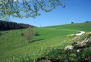
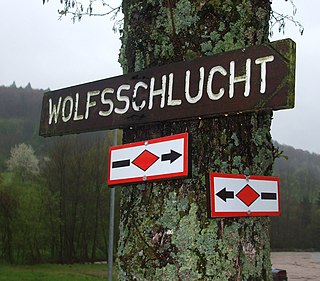
The Westweg is a long-distance hiking trail in Germany, running north–south through the Black Forest from Pforzheim to Basel. The trail is around 285 km long, and was founded in 1900. It is currently maintained under the auspices of the Black Forest Club. The trail symbol is a red lozenge on a white background. The Westweg is a part of the European Long-distance Trail E1 The route passes through or near numerous villages or small towns, so there is no difficulty in finding overnight accommodation and meals along the route. It would actually require more planning to walk it while staying in youth hostel-type accommodation, or camping. There are a number of services that will transport your luggage to the next accommodation by vehicle, leaving the hikers with only their daypacks for the hike. The route can be accessed at several places along its length by road or public transport, so it is easy to walk part of it or to do day walks along its route.
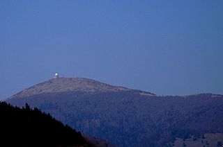
The Belchen, 1,414 metres (4,639 ft), or Black Forest Belchen is the fourth-highest summit of the Black Forest after Feldberg, Seebuck and Herzogenhorn. The municipalities of Münstertal, Schönenberg and Kleines Wiesental meet on the summit dome of Belchen which is located in the southwest German state of Baden-Württemberg.
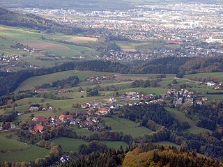
The Brandenkopf is 945.2 m above sea level (NHN) and one of the highest mountains in the Central Black Forest in southern Germany. The mountain lies in the county of Ortenaukreis in the state of Baden-Württemberg within the municipalities of Oberharmersbach, Fischerbach and Hausach, its summit is part of Oberharmersbach. The mountain forms the prominent centrepiece between the valleys of the Kinzig, the Wolf and the Harmersbach.
The Herzogenhorn is a mountain, 1,415.2 m above sea level (NHN), in the southwest German state of Baden-Württemberg. It lies within a nature reserve in the municipality of Bernau im Schwarzwald.
The Hochkopf is a wooded ridge north of the village of Todtmoos in the southern part of the High Black Forest. At 1,263.4 m above sea level (NHN) its summit is one of the 20 highest points in the German state of Baden-Württemberg.
The Belchenflue is a mountain of the Jura, located on the border between the Swiss cantons of Basel-Landschaft and Solothurn, south of Eptingen. The nearby Belchenflue Pass links the two cantons.
The Petit Ballon or Little Belchen, is, at 1272m, one of the highest peaks of the Vosges Mountains in the department of Haut-Rhin, Alsace in France, about 5 km away from the village of Wasserbourg. The Rothenbrunnen mountain hut is 500m below. A car park is a further 500m away.
The Southern Black Forest is the highest part of the Black Forest, an area heavily transformed by ice age glaciation south of a line roughly from Freiburg im Breisgau to Donaueschingen. The term High Black Forest is not quite identical; that usually includes the highest part of the Central Black Forest, southeast of the Elz valley, as well. The Southern Black Forest Nature Park also takes in this area, extending across the whole of the High Black Forest as well as several peripheral areas.
The Belchen System refers to five mountains with the name Belchen around the tripoint of Germany, France and Switzerland that may have been used by the Celts as a solar calendar. The term is an extension of the Belchen Triangle. The mountains are:
This page is based on this Wikipedia article Text is available under the CC BY-SA 4.0 license; additional terms may apply. Images, videos and audio are available under their respective licenses.