
Bulgaria is a country situated in Southeast Europe that occupies the eastern quarter of the Balkan peninsula, being the largest country within its geographic boundaries. It borders Romania to the north, Serbia and North Macedonia to the west, Greece and Turkey to the south, and the Black Sea to the east. The northern border with Romania follows the river Danube until the city of Silistra. The land area of Bulgaria is 110,994 square kilometres (42,855 sq mi), slightly larger than that of Cuba, Iceland or the U.S. state of Tennessee. Considering its relatively compact territorial size and shape, Bulgaria has a great variety of topographical features. Even within small parts of the country, the land may be divided into plains, plateaus, hills, mountains, basins, gorges, and deep river valleys. The geographic center of Bulgaria is located in Uzana.

With an area of 238,397 km2 (92,046 sq mi), Romania is the twelfth-largest country in Europe. It is a Balkan country located at the crossroads of Eastern and Southeast Europe. It's bordered on the Black Sea, the country is halfway between the equator and the North Pole and equidistant from the westernmost part of Europe—the Atlantic Coast—and the most easterly—the Ural Mountains. Romania has 3,195 kilometres (1,985 mi) of border. Moldova and Ukraine lie to the east, Bulgaria to the south, and Serbia and Hungary to the west by the Pannonian Plain. In the southeast, 245 kilometres (152 mi) of sea coastline provide an important outlet to the Black Sea and the Atlantic Ocean.

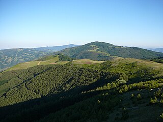
The Rhodopes are a mountain range in Southeastern Europe, and the largest by area in Bulgaria, with over 83% of its area in the southern part of the country and the remainder in Greece. Golyam Perelik is its highest peak at 2,191 meters (7,188 ft). The mountain range gives its name to the terrestrial ecoregion Rodope montane mixed forests that belongs in the temperate broadleaf and mixed forests biome and the Palearctic realm. The region is particularly notable for its karst areas with their deep river gorges, large caves and specific sculptured forms, such as the Trigrad Gorge.
Zlatograd is a town in Smolyan Province, southern-central Bulgaria. It is the administrative centre of the homonymous Zlatograd Municipality. In December 2009, the town had a population of 7,110.

Felsőzsolca is a small town in Borsod-Abaúj-Zemplén county, in northern Hungary, in the Miskolc agglomeration. It is the city with the tenth highest population in Borsod-Abaúj-Zemplén county and the second biggest in the Miskolc agglomeration.

Boboshevo is a town in Western Bulgaria. It is located in Kyustendil Province and is close to the towns of Kocherinovo and Rila.

Elhovo is a Bulgarian town in Yambol Province, located on the left bank of the Tundzha river, between Strandzha and Sakar mountains. Second largest city in the region after Jambol, the city is located at 36 km from border checkpoint Lesovo – Hamzabeyli on the Bulgarian – Turkish border. Elhovo is the administrative center of Elhovo municipality, which includes 21 villages (municipalities). The city's population as of 15 March 2023, was 9422 inhabitants.

Strandzha is a mountain massif in southeastern Bulgaria and East Thrace, the European part of Turkey. It is in the southeastern part of the Balkans between the plains of Thrace to the west, the lowlands near Burgas to the north, and the Black Sea to the east. Its highest peak is Mahya Dağı in Turkey, while the highest point on Bulgarian territory is Golyamo Gradishte. The total area is approximately 10,000 km2 (3,861 sq mi).
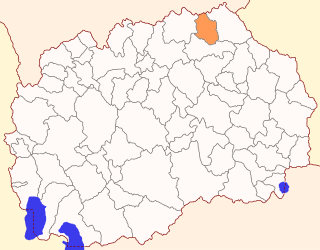
Rankovce is a municipality in the northeastern region of the Republic of North Macedonia. Rankovce is also the name of the town where the municipal seat is found. Rankovce Municipality is part of the Northeastern statistical region.

The Jerma or Erma is a river in southeastern Serbia and western Bulgaria. It is notable for passing the Bulgarian-Serbian border twice.

The Dospat is a river in the Western Rhodope Mountains, the most important tributary of the Mesta.
Ograzhden is a mountain range shared by southwestern Bulgaria and southeastern North Macedonia. The highest peak of the mountain is located in North Macedonia, Ograzhdenets (Огражденец) at 1,744 m, while the highest in Bulgaria is Bilska Chuka at 1,644 m.

Midžor or Midzhur is a peak in the Balkan Mountains, situated on the border between Bulgaria and Serbia. At 2,169 metres (7,116 ft), it is the highest peak of the Western Balkan Mountains, as well as the highest in Serbia.
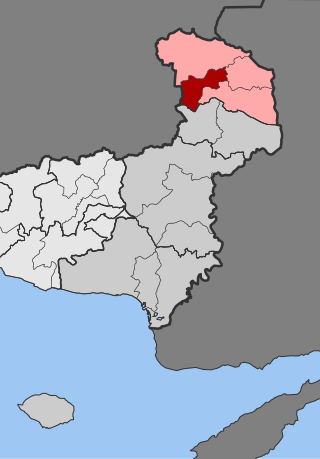
Kyprinos is a town and a former municipality in the Evros regional unit, East Macedonia and Thrace, Greece. Since the 2011 local government reform it is part of the municipality Orestiada, of which it is a municipal unit. The municipal unit has an area of 135.976 km2. In 2021 its population was 571 for the community and 1,732 for the municipal unit. Kyprinos is located southwest of Edirne, Turkey, west-northwest of Orestiada, north of Alexandroupoli and about 5 to 6 km east of Kurdzhali and the Bulgarian frontier, where there is a border crossing. Athens is approximately 1,050 km to the southwest. Komara is on the other side of the river Ardas.

Slivnitsa is a town in western Bulgaria, 22 km away from Sofia, lying on the main road connecting the capital with the Bulgarian-Serbian border. Slivnitsa is part of Sofia Province and is close to the towns of Kostinbrod and Dragoman.

The Rezovo is a river in the extreme southeast of Bulgaria and northernmost part of European Turkey. The river is situated in Bulgaria's Strandzha Nature Park.
Brodilovo is a remote village in the Strandzha (Strandja) mountains of southeastern Bulgaria, within the range of the national park preserve, and part of Tsarevo Municipality, Burgas Province. Lying on the left bank of the Veleka, as of 2005 it has a population of 363 and the mayor is Dimitar Dimitrov. Brodilovo is in a fertile valley ringed by mountains, located at 42°5′N27°51′E, 56 metres above sea level, close to the sea, but 12 km south of the port of Tsarevo. The name of the village is derived from its location near a convenient river ford. Historically a centre of Thracian folklore and artisans, there are many unexcavated sites close by, though there is no mapping of the numerous trails and watercourses, partly because of it being in a sensitive border area with Turkey.

The Drina is a 346 km (215 mi) long river in the Balkans, which forms a large portion of the border between Bosnia and Herzegovina and Serbia. It is the longest tributary of the Sava River and the longest karst river in the Dinaric Alps which belongs to the Danube River drainage basin. Its name is derived from the Roman name of the river which in turn is derived from Greek.
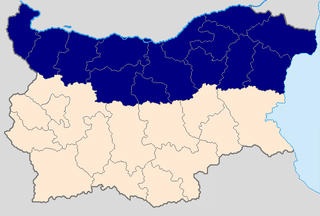
Northern Bulgaria, also called Moesia is the northern half of Bulgaria, located to the north of the main ridge of the Balkan Mountains which conventionally separates the country into a northern and a southern part. Besides the Balkan Mountains, Northern Bulgaria borders the Timok River and Serbia to the west, the Danube River and Romania to the north, and the Bulgarian Black Sea Coast to the east.

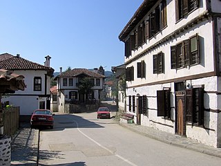
Brashlyan is a village in Malko Tarnovo Municipality, in Burgas Province, in southeastern Bulgaria.. Known as Sarmashik until 1934, today the entire village is an architectural reserve displaying characteristic Strandzha wooden architecture from the mid-17th to the 19th century.


