
Burgas, sometimes transliterated as Bourgas, is the second largest city on the Bulgarian Black Sea Coast in the region of Northern Thrace and the fourth-largest city in Bulgaria after Sofia, Plovdiv, and Varna, with a population of 203,000 inhabitants, while 277,922 live in its urban area. It is the capital of Burgas Province and an important industrial, transport, cultural and tourist centre.

Pomaks are Bulgarian-speaking Muslims inhabiting Bulgaria, northwestern Turkey, and northeastern Greece. The c. 220,000 strong ethno-confessional minority in Bulgaria is recognized officially as Bulgarian Muslims by the government. The term has also been used as a wider designation, including also the Slavic Muslim populations of North Macedonia and Albania.

Dobruja or Dobrudja is a geographical and historical region in Southeastern Europe that has been divided since the 19th century between the territories of Bulgaria and Romania. It is situated between the lower Danube River and the Black Sea, and includes the Danube Delta, the Romanian coast, and the northernmost part of the Bulgarian coast. The territory of Dobruja is made up of Northern Dobruja, which is a part of Romania, and Southern Dobruja, which is a part of Bulgaria.

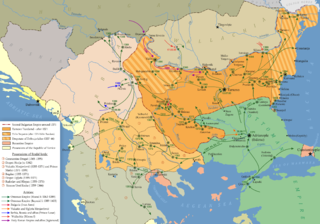
Eastern Rumelia was an autonomous province of the Ottoman Empire with a total area of 32,978 km2, which was created in 1878 by virtue of the Treaty of Berlin and de facto ceased to exist in 1885, when it was united with the Principality of Bulgaria, also under nominal Ottoman suzerainty. It continued to be an Ottoman province de jure until 1908, when Bulgaria declared independence. Ethnic Bulgarians formed a majority of the population in Eastern Rumelia, but there were significant Turkish and Greek minorities. Its capital was Plovdiv. The official languages of Eastern Rumelia were Bulgarian, Greek and Ottoman Turkish.
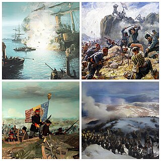
The Russo-Turkish War was a conflict between the Ottoman Empire and a coalition led by the Russian Empire which included Bulgaria, Romania, Serbia, and Montenegro. Fought in the Balkans and in the Caucasus, it originated in emerging 19th-century Balkan nationalism. Additional factors included the Russian goals of recovering territorial losses endured during the Crimean War of 1853–1856, re-establishing itself in the Black Sea and supporting the political movement attempting to free Balkan nations from the Ottoman Empire.

The 1878 Preliminary Treaty of San Stefano was a treaty between the Russian and Ottoman empires at the conclusion of the Russo-Turkish War of 1877–1878. It was signed at San Stefano, then a village west of Constantinople, on 3 March [O.S. 19 February] 1878 by Count Nicholas Pavlovich Ignatiev and Aleksandr Nelidov on behalf of the Russian Empire and by Foreign Minister Saffet Pasha and Ambassador to Germany Sadullah Bey on behalf of the Ottoman Empire.

Belitsa is a town in southwestern Bulgaria, located in the Belitsa Municipality of the province of Blagoevgrad.
Kiliia or Kilia is a city in Izmail Raion, Odesa Oblast, southwestern Ukraine. It hosts the administration of Kiliia urban hromada, one of the hromadas of Ukraine. Kiliia is located in the Danube Delta, in the historic Bessarabian district of Budjak; across the river lies the town of Chilia Veche in Romania. The Chilia branch of the Danube river, which separates Ukraine from Romania, is named after it. Population: 18,745.
The history of Ottoman Bulgaria spans nearly 500 years, beginning in the late 14th century, with the Ottoman conquest of smaller kingdoms from the disintegrating Second Bulgarian Empire. In the late 19th century, Bulgaria was liberated from the Ottoman Empire, and by the early 20th century it was declared independent.

Bulgarian Turks are ethnic Turks from Bulgaria. According to the 2021 census, there were 508,375 Bulgarians of Turkish descent, roughly 8.4% of the population, making them the country's largest ethnic minority. Bulgarian Turks also comprise the largest single population of Turks in the Balkans. They primarily live in the southern province of Kardzhali and the northeastern provinces of Shumen, Silistra, Razgrad and Targovishte. There is also a diaspora outside Bulgaria in countries such as Turkey, Austria, the Netherlands, Sweden, Norway and Romania, the most significant of which are the Bulgarian Turks in Turkey.

Muhacir are the estimated millions of Ottoman Muslim citizens, and their descendants born after the onset of the dissolution of the Ottoman Empire, mostly Turks but also Albanians, Bosniaks, Greek Muslims, Circassians, Crimean Tatars, Pomaks, Serb Muslims, Georgian Muslims, and Muslim Roma who emigrated to East Thrace and Anatolia from the late 18th century until the end of the 20th century, mainly to escape ongoing persecution in their homelands. Up to a third of modern-day population in Turkey may have ancestry from these Turkish and other Muslim migrants.
Mega Dereio is a village in the central part of the Evros regional unit in Greece. It is part of the municipal unit of Orfeas within the municipality of Soufli. Together with 6 other villages, it forms the community of Mikro Dereio. It is situated near the upper course of the river Erythropotamos, in the Eastern Rhodope Mountains. The Greek National Road 53 passes through the village.

The Circassians in Kosovo were a group of the Circassian people who lived in Kosovo beginning in the mid-19th century, when they were exiled during the Circassian genocide to the Ottoman Empire after the Russo-Circassian War. During this time, the Circassians in Kosovo were from three of the twelve Adyghe tribes: the Abzakh, Shapsug and Ubykh. In 1998 they numbered 200.
The demographics of the Ottoman Empire include population density, ethnicity, education level, religious affiliations and other aspects of the population.
Mavrochori, until 1927 known as Tisova, is an abandoned village in the Drama regional unit, Greece. The settlement, which became part of the community of Mylopetra in 1931, was dissolved in 1940.

Veselie is a village in Primorsko Municipality, Burgas Province, in southeastern Bulgaria. As of 2013 it has 539 inhabitants.

The Circassians in Bulgaria were a large ethnic minority in the territory that constitutes modern Bulgaria. In the late 19th century, they numbered around 150,000. In 1992, 573 people in the country identified themselves as Circassian.

The Stara Zagora massacre was the mass murder of approx. 14,000 civilian Bulgarians, accompanied by the burning and complete destruction of the City of Stara Zagora on 31 July–2 August [O.S. 19–21 July] 1877, committed by regular Ottoman troops commanded by Süleyman Hüsnü Pasha, during the eponymous battle of the Russo-Turkish War (1877-1878).

The Orthodox church of St. Athanasius is a church in Poroishte, Bulgaria, near Razgrad. It was built in the 17th century, and was built with a single nave dug into the ground. Nowadays, it is the only dug-in church left from the Ottoman rule in Northeastern Bulgaria.
The Terror is the name given to the five-month reign of terror that the Bulgarian population of the town of Karlovo suffered at the hands of the Ottoman authorities from 22 July 1877 to 28 December 1877, during the Russo-Turkish War (1877-1878).

