Montana is a state in the Mountain West division of the Western United States. It is bordered by Idaho to the west, North Dakota and South Dakota to the east, Wyoming to the south, and the Canadian provinces of Alberta, British Columbia, and Saskatchewan to the north. It is the fourth-largest state by area, the eighth-least populous state, and the third-least densely populated state. Its state capital is Helena, while the largest city is Billings. The western half of Montana contains numerous mountain ranges, while the eastern half is characterized by western prairie terrain and badlands, with smaller mountain ranges found throughout the state. The state has a reputation for a libertarian bent in popular opinion and policy.

Belknap County is a county in the U.S. state of New Hampshire. As of the 2020 census, the population was 63,705. The county seat is Laconia. It is located in New Hampshire's Lakes Region, slightly southeast of the state's geographic center. Belknap County comprises the Laconia, NH Micropolitan Statistical Area, which in turn constitutes a portion of the Boston-Worcester-Providence, MA-RI-NH-CT Combined Statistical Area.

Treasure County is a county in the U.S. state of Montana. As of the 2020 census, the population was 762, making it the second-least populous county in Montana. Its county seat is Hysham. The county was founded in 1919.

Powell County is a county in the U.S. state of Montana. As of the 2020 census, the population was 6,946. Its county seat is Deer Lodge.

Meagher County is a county located in the U.S. state of Montana. As of the 2020 census, the population was 1,927. Its county seat is White Sulphur Springs.

Madison County is a county in the U.S. state of Montana. As of the 2020 census, the population was 8,623. Its county seat is Virginia City. The county was founded in 1865; at the time it was part of the Montana Territory.
Granite County is a county located in the U.S. state of Montana. As of the 2020 census, the population was 3,309. Its county seat is Philipsburg. The county was founded in 1893, and was named for a mountain which contains the Granite Mountain silver mine.

Custer County is a county located in the U.S. state of Montana. As of the 2020 census, the population was 11,867. Its county seat is Miles City. The county was established on June 2, 1865, as one of the nine original counties of the Territory of Montana named Big Horn County, and was renamed on February 16, 1877, in honor of Lieutenant Colonel George Armstrong Custer.

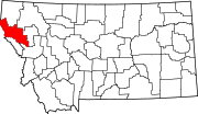
Blaine County is a county in the U.S. state of Montana. As of the 2020 census, the population was 7,044. Its county seat is Chinook. The county was named for James G. Blaine, former United States Secretary of State. It is on the north line of the state, and thus shares the southern border of Canada opposite Saskatchewan.

Belknap is a village in Johnson County, Illinois, United States. The population was 104 at the 2010 census.

Fort Belknap Agency is a census-designated place (CDP) in Blaine County, Montana, United States. As of the 2010 census, its population was 1,293.

Harlem is a city in Blaine County, Montana, United States. The population was 769 at the 2020 census.

Hays is a census-designated place (CDP) in Blaine County, Montana, United States. The population was 843 at the 2010 census. The community lies within the Fort Belknap Indian Reservation, near the reservation's southern end. The nearby community of Lodge Pole lies to the east.

Lodge Pole is a census-designated place (CDP) in Blaine County, Montana, United States. The population was 265 at the 2010 census. It lies within the Fort Belknap Indian Reservation, near the reservation's southern end.

Havre is the county seat and largest city in Hill County, Montana, United States. Havre is nicknamed the crown jewel of the Hi-Line. It is said to be named after the city of Le Havre in France. As of the 2020 census the population was 9,362.

Gilford is a town in Belknap County, New Hampshire, United States. The population was 7,699 at the 2020 census, up from 7,126 at the 2010 census. Situated on Lake Winnipesaukee, Gilford is home to Governors Island, Ellacoya State Beach, Belknap Mountain State Forest, Gunstock Mountain Resort, and the Bank of New Hampshire Pavilion, a seasonal outdoor concert venue. The lakeside village of Glendale lies within Gilford's borders.

Meredith is a town in Belknap County, New Hampshire, United States. The population was 6,662 at the 2020 census. Meredith is situated in the state's Lakes Region and serves as a major resort town. Meredith Village, the commercial center of the town, lies long the shores of Lake Winnipesaukee, and several other large lakes lie partially or completely within the town borders. It is home to the Stonedam Island Natural Area and the Winnipesaukee Scenic Railroad, and it serves as one of the ports of call for the MS Mount Washington.
Zortman is a census-designated place and unincorporated community in Phillips County, Montana, United States. Its population was 69 as of the 2010 census. Zortman has a post office with ZIP code 59546.