Yellowstone County is the most populous county in the U.S. state of Montana. As of the 2020 census, the population was 164,731. Its county seat is Billings, the state's most populous city. Like the nearby park, Yellowstone County is named after the Yellowstone River which roughly bisects the county, flowing southwest to northeast. The river, in turn, was named for the yellow sandstone cliffs in what is now Yellowstone County.

Wibaux County is a county in the U.S. state of Montana. As of the 2020 census, the population was 937, making it the fourth-least populous county in Montana. Its county seat is Wibaux.

Treasure County is a county in the U.S. state of Montana. As of the 2020 census, the population was 762, making it the second-least populous county in Montana. Its county seat is Hysham. The county was founded in 1919.

Sheridan County is a county in the U.S. state of Montana. As of the 2020 census, the population was 3,539. Its county seat is Plentywood. Its northern boundary is the Canada–United States border south of Saskatchewan.

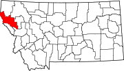
Sanders County is a county in the U.S. state of Montana. As of the 2020 census, the population was 12,400. Its county seat is Thompson Falls. The county was founded in 1905.

Powell County is a county in the U.S. state of Montana. As of the 2020 census, the population was 6,946. Its county seat is Deer Lodge.

Madison County is a county in the U.S. state of Montana. As of the 2020 census, the population was 8,623. Its county seat is Virginia City. The county was founded in 1865; at the time it was part of the Montana Territory.

Jefferson County is a county in Montana, United States. As of the 2020 census, the population was 12,085. Its county seat is Boulder. The county was created in 1865 and named for President Thomas Jefferson.
Granite County is a county located in the U.S. state of Montana. As of the 2020 census, the population was 3,309. Its county seat is Philipsburg. The county was founded in 1893, and was named for a mountain which contains the Granite Mountain silver mine.

Fallon County is a county located in the U.S. state of Montana. As of the 2020 census, the population was 3,049. Its county seat is Baker. The county was created in 1913 from a portion of Custer County. It is named for Benjamin O'Fallon, a nephew of Captain William Clark and an Indian agent for the upper Missouri region from 1823 to 1827.

Custer County is a county located in the U.S. state of Montana. As of the 2020 census, the population was 11,867. Its county seat is Miles City. The county was established on June 2, 1865, as one of the nine original counties of the Territory of Montana named Big Horn County, and was renamed on February 16, 1877, in honor of Lieutenant Colonel George Armstrong Custer.

Jefferson County is a county located in the U.S. state of Idaho. As of the 2020 Census, the county's population was 30,891. The county seat and largest city is Rigby. The county was established in 1913 and named after Thomas Jefferson, the third U.S. President. Jefferson County is part of the Idaho Falls, ID Metropolitan Statistical Area.

Clark County is a rural county in the U.S. state of Idaho; its county seat and largest city is Dubois. As of the 2020 census, the population was 790, making it the least populous county in the state.

Camas County is a county in the southern portion of the U.S. state of Idaho. The county seat and largest city is Fairfield. The county was established 107 years ago in 1917 by the Idaho Legislature with a partition of Blaine County on February 6. It is named for the camas root, or Camassia, a lily-like plant with an edible bulb found in the region, that Native Americans and settlers used as a food source. As of the 2020 census, the population was 1,077, making it the second-least populous county in the state, after Clark County.
Ferdinand is a city in Idaho County, Idaho, United States. The population was 159 at the 2010 census, up from 145 in 2000. At the southern end of the Nez Perce Indian Reservation, it was founded by F.M. Bieker shortly after the reservation was opened for settlement in 1895. It was named after Ferdinand, Indiana, where his mother's family had lived.

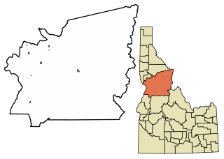
Grangeville is the largest city in and the county seat of Idaho County, Idaho, United States, in the north central part of the state. Its population was 3,141 at the 2010 census, down from 3,228 in 2000.

Hot Springs is a town on the Flathead Indian Reservation in Sanders County, Montana, United States. The population was 557 at the 2020 census.

Camas is a city in Clark County, Washington, with a population of 26,065 at the 2020 census. The east side of town borders the city of Washougal, Washington, and the west side of town borders Vancouver, Washington. Camas lies along the Washington side of the Columbia River, across from Troutdale, Oregon, and is part of the Portland metropolitan area.
Potomac is an unincorporated community and census-designated place (CDP) in Missoula County, Montana, United States. It is in the southeastern part of the county, in the valley of Camas Creek and Union Creek, which flows northwest to the Blackfoot River, part of the Clark Fork watershed.