
The South Tynedale Railway is a preserved, 2 ft narrow gauge heritage railway in Northern England and at 875ft is England's second highest narrow gauge railway after the Lynton & Barnstaple Railway. The line runs from Alston in Cumbria, down the South Tyne Valley, via Gilderdale, Kirkhaugh and Lintley, then across the South Tyne, Gilderdale and Whitley Viaducts to Slaggyford in Northumberland.

The River Tyne is a river in North East England and its length is 73 miles (118 km). It is formed by the confluence of two rivers: the North Tyne and the South Tyne. These two rivers converge at Warden Rock near Hexham in Northumberland at a place dubbed 'The Meeting of the Waters'.
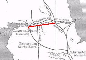
The Stanegate, was an important Roman road built in what is now northern England. It linked two forts that guarded important river crossings: Corstopitum (Corbridge) on the River Tyne in the east, and situated on Dere Street, and Luguvalium (Carlisle) on the River Eden in the west. The Stanegate ran through the natural gap formed by the valleys of the River Tyne in Northumberland and the River Irthing in Cumbria. It predated Hadrian's Wall by several decades; the Wall would later follow a similar route, slightly to the north.

The A69 is a major northern trunk road in England, running east–west across the Pennines, through the counties of Tyne and Wear, Northumberland and Cumbria. Originally, the road started in the centre of Newcastle upon Tyne then later near Birtley, but since the creation of the A1 Western Bypass around Newcastle upon Tyne, it now starts at Denton Burn, a suburb of Newcastle upon Tyne.

Haltwhistle is a market town and civil parish in Northumberland, England, 10 miles (16 km) east of Brampton. It had a population of 3,811 at the 2011 Census.

Wark on Tyne is a small village and civil parish in Northumberland, England, 12 miles (19 km) north of Hexham. The name is derived from the Anglo-Saxon word for earthworks, and refers to the mound at the south of the village. Wark was once the capital town of Tynedale. A Bronze Age stone circle known as The Goatstones is near Ravensheugh crags in the parish.

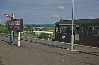
Haltwhistle is a railway station on the Tyne Valley Line, which runs between Newcastle and Carlisle via Hexham. The station, situated 22+3⁄4 miles (37 km) east of Carlisle, serves the market town of Haltwhistle in Northumberland, England. It is owned by Network Rail and managed by Northern Trains.

Greenhead is a village in Northumberland, England. The village is on the Military Road (B6318), about 17 miles (27 km) from Chollerford, 3 miles (5 km) from Haltwhistle and 9 miles (14 km) from Brampton, Cumbria along the A69 road. The A69 road bypasses the village, but until the 1980s all vehicular traffic passed through the village. The village lies just outside the Northumberland National Park, close to Hadrian's Wall. Just to the north of the village is the 12th-century Thirlwall Castle, recently restored and opened to the public. Nearby villages include Upper Denton and Haltwhistle.
The Alston Line was a 13-mile (21 km) single-track branch line, which linked Haltwhistle in Northumberland with Alston in Cumbria.

Bellister Castle is a National Trust owned castellated 19th-century mansion house attached to the ruinous remains of a 14th-century tower house, near Haltwhistle, Northumberland, England. It is a Scheduled Ancient Monument and a Grade I listed building.

Henshaw is a small village and civil parish in Northumberland, within the vicinity of the ancient Hadrian's Wall. It is located around 11.5 miles (19 km) from Hexham, 25.5 miles (41 km) from Carlisle, and 33 miles (53 km) from Newcastle upon Tyne.

The Haltwhistle Burn is a river which lies to the east of the Northumbrian town of Haltwhistle. Rising in the peaty uplands below the ridge of the Whin Sill, the burn passes through the Roman Military Zone south of Hadrian's Wall and through a dramatic sandstone gorge before descending between wooded banks to the South Tyne Valley. The Haltwhistle Burn drains an area of approximately 42 km2. Today the Burn is a haven for wildlife and a popular walk for residents and tourists but from Roman times until the 1930s the combination of valuable minerals and water power attracted a succession of industries which provided goods and employment to the town.

Lambley, formerly known as Harper Town, is a village in Northumberland, England about four miles (6 km) southwest of Haltwhistle.The village lies adjacent to the River South Tyne. The place name Lambley refers to the "pasture of lambs". Lambley used to be the site of a small convent of Benedictine Nuns, founded by Adam de Tindale and Heloise, his wife, in the 12th century. The Scots led by William Wallace devastated it in 1296 [Rowland gives 1297]. However it was restored and one William Tynedale was ordained priest to the nunnery in about 1508 – most likely not William Tyndale, the reformer, as once believed but another man of the same name. At the time of the suppression of religious houses by Henry VIII, the nunnery contained six inmates. Nothing now remains but the bell from the nunnery, which hangs in the church, and a few carved stones. The village lies in the Midgeholme Coalfield and there are reserves of good-quality coal remaining.

The Tyne Valley Line is a 58-mile (93 km) route, linking Newcastle upon Tyne with Hexham and Carlisle. The line follows the course of the River Tyne through Tyne and Wear and Northumberland. Five stations and two viaducts on the route are listed structures.

The Newcastle & Carlisle Railway (N&CR) was an English railway company formed in 1825 that built a line from Newcastle upon Tyne on Britain's east coast, to Carlisle, on the west coast. The railway began operating mineral trains in 1834 between Blaydon and Hexham, and passengers were carried for the first time the following year. The rest of the line opened in stages, completing a through route between Carlisle and Gateshead, south of the River Tyne in 1837. The directors repeatedly changed their intentions for the route at the eastern end of the line, but finally a line was opened from Scotswood to a Newcastle terminal in 1839. That line was extended twice, reaching Newcastle Central station in 1851.

Haltwhistle A69 Bridge, East is a concrete bridge across the River South Tyne at Haltwhistle in Northumberland, England.

Alston Arches Viaduct, also known as Haltwhistle Viaduct, is a stone bridge across the River South Tyne at Haltwhistle in Northumberland, England.

The Blue Bridge is an iron bridge across the River South Tyne at Haltwhistle in Northumberland, England.

Haltwhistle A69 Bridge, West is a concrete bridge across the River South Tyne at Haltwhistle in Northumberland, England.

