
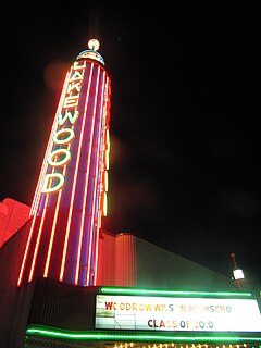
Deep Ellum is an American neighborhood composed largely of arts and entertainment venues near downtown in East Dallas, Texas. The name is based on a corruption of the area's principal thoroughfare, Elm Street. Older alternative uses include Deep Elm and Deep Elem.

Capitol Hill is a densely populated residential district in Seattle, Washington, United States. One of the city's most popular nightlife and entertainment districts, it is home to a historic gay village and vibrant counterculture community.

Downtown Newark is the Central Business District of Newark in Essex County, New Jersey, United States.
Lakewood is a neighborhood in East Dallas, Texas (USA). It is adjacent to White Rock Lake and Northeast of Downtown Dallas. Lakewood is bound by Mockingbird Lane to the north, Abrams Road to the west, Gaston Avenue to the south, and White Rock Lake to the east.
The Main Street District of downtown Dallas, Texas runs along Main Street and is bounded by Elm Street one block north, Commerce St. one block south, N. Lamar St. to the west, and US 75/I-45 (I-345) elevated highway to the east. The district is the spine of downtown Dallas, and connects many of the adjoining business and entertainment districts. It does not include Dealey Plaza or the John Fitzgerald Kennedy Memorial which are a few blocks west in the West End Historic District.

The Cedars is a district in south Dallas, Texas (U.S.). It is adjacent to and south of downtown and Interstate 30, east of Austin Street, north of Corinth Street, and west of the 75 & 345 Overpasses just east of South Good Latimer Expy.

Near Northeast is a Syracuse, New York neighborhood, located northeast of the city's downtown. It corresponds to Onondaga County Census Tract 15, 16, 23, and 24.
Vickery Place is a historic neighborhood in East Dallas, Texas, bounded on the north by Goodwin Avenue, on the west by North Central Expressway and Henderson, on the south by Belmont, and on the east by Greenville Avenue. Although Vickery Place is considered by some to be part of the M Streets area, it is strictly speaking not as it is south of the Greenland Hills subdivision. Vickery Place has seen much improvement and property value growth over the past several years due to its close proximity to Downtown Dallas and Uptown, and its location bordering the vibrant Lower Greenville Avenue and Knox-Henderson entertainment and shopping districts.
Casa Linda Estates, or simply Casa Linda is a neighborhood in east Dallas, Texas (USA). It is situated to the south and east of White Rock Lake and to the south of Garland Road. It is in Dallas Council District 9.
Phoenix Hill is a neighborhood of Louisville, Kentucky just east of Downtown. Its boundaries are Market Street to the North, Preston Street to the West, Broadway to the South, and Baxter Avenue to the East. The Phoenix Hill neighborhood, settled before 1850 by German immigrants, is now a rich tapestry of people and a diverse mix of business, industry and residences.
Bryan Place is a neighborhood in Old East Dallas, Texas (USA). It is east of the Arts District of downtown and the State Thomas neighborhood, north of Deep Ellum, south of Cityplace and west of Munger Place. Its boundaries are generally considered to be US-75 North Central Expressway on the west, Ross Avenue on the (north)west, N. Washington Street on the (north)east, and Live Oak Avenue on the (south)east.
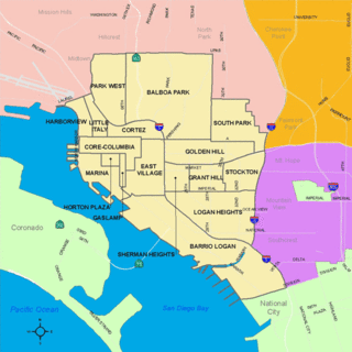
South Park is a neighborhood in San Diego, California adjacent to the southeast corner of Balboa Park. It stands out in San Diego for its tree-lined streets and walkable business district.
The City of Oklahoma City uses Special Zoning Districts as a tool to maintain the character of many neighborhood communities.
Lower Greenville is a neighborhood in east Dallas, Texas (USA), west of Lakewood. Specifically, the neighborhood is the area adjacent to Greenville Avenue south of Mercedes Avenue and north of Belmont Avenue. The area south of Belmont Avenue is often, and more specifically, called "Lowest Greenville," and the area north of Mockingbird Lane is called "Upper Greenville." "Lower Greenville" is also used to refer to the neighborhoods surrounding Greenville Avenue, including Vickery Place, the Belmont Addition, Glencoe, Greenland Hills, and Stonewall Terrace. It straddles Dallas Council Districts 14 and 2.
Love Field is a neighborhood located in northwest Dallas, Texas (USA). It lies southwest of and is adjacent to Dallas Love Field Airport and is bounded by Denton Drive, Inwood Road, Harry Hines Boulevard, and Webb Chapel Extension. The neighborhood takes its name from Love Field Airport.
Wynnewood is one of the main neighborhoods of Oak Cliff, the southwestern part of Dallas, Texas, United States. Wynnewood covers 820 acres (3.3 km2). The village was once known for buildings having old decorative wood flooring.

Old Gold Coast is the name of a historic district in south Omaha, Nebraska. With South 10th Street as the central artery, the area was home to neighborhoods such as Little Italy and Forest Hill. The area is referred to as "old" because it was replaced in prominence in the late 19th century when a new district usurped its importance. This area south of downtown was generally bounded by Leavenworth Street on the north, Bancroft Street on the south, the Missouri River on the east, and South 16th Street on the west.

Uptown is a PID and a dense upscale neighborhood in Dallas, Texas. Uptown is north of and adjacent to downtown Dallas, and is bordered by US 75 on the east, N Haskell Avenue on the northeast, the Katy Trail on the northwest, Bookhout Street and Cedar Springs Road on the west, N Akard Street on the southwest and Spur 366 on the south.

Lincoln, Nebraska has many neighborhoods, including 45 recognized by Urban Development, City of Lincoln. A list and description of neighborhoods within Lincoln city limits follows.
Trinity Groves is a restaurant and retail development in West Dallas, at the western end of the Margaret Hunt Hill Bridge. The development is owned and managed by Stuart Fitts, Larry McGregor, and Phil Romano.
