
Sutter's Fort was a 19th-century agricultural and trade colony in the Mexican Alta California province. Established in 1839, the site of the fort was originally part of a utopian colonial project called New Helvetia by its builder John Sutter, though construction of the fort proper would not begin until 1841. The fort was the first non-Indigenous community in the California Central Valley, and saw grave mistreatment of Indigenous laborers in plantation or feudal style conditions. The fort is famous for its association with the Donner Party, the California Gold Rush, and the formation of the city of Sacramento, surrounding the fort. It is notable for its proximity to the end of the California and Siskiyou Trails, which it served as a waystation.

Arden-Arcade is a census-designated place (CDP) in Sacramento County, California, United States. The population was 94,659 at the 2020 census, making it the second most populous census-designated place in California. It is east of the city of Sacramento and west of the community of Carmichael.
Albany Park is one of 77 well-defined community areas of Chicago, Illinois, United States. Located on the Northwest Side of the City of Chicago with the North Branch of the Chicago River forming its east and north boundaries, it includes the ethnically diverse Albany Park neighborhood, with one of the highest percentages of foreign-born residents of any Chicago neighborhood.

The Los Rios Community College District is a special-purpose district providing administrative services and governance for the community colleges serving the greater Sacramento area and points east all the way to Lake Tahoe.
The Sacramento Convention Center Complex is a complex of entertainment venues and a convention center located in downtown Sacramento, California. The complex consists of the SAFE Credit Union Performing Arts Center, the Sacramento Memorial Auditorium, and the Jean Runyon Little Theater.
The Alhambra Theatre opened in 1927 and was the preeminent movie house in the greater Sacramento area for many years. It was designed in the Moorish style of the great Spanish cities and included a large courtyard and fountain. The interior was lavishly appointed with red carpet, gold trim, and large pillars. It was located directly beyond the eastern terminus of K Street at 1025 Thirty-First Street, now Alhambra Boulevard, Sacramento, California 95816, in the East Sacramento neighborhood.
Elmhurst is a historic residential neighborhood located in the eastern part of Sacramento, California. Elmhurst is known for its large elm, ash, and oak trees that provide shady canopy for the neighborhood.
Collinsville is a rural unincorporated community in Solano County, California, United States. It is located at the mouth of the Sacramento River, on the north side of the river where it debouches into the Suisun Bay. Collinsville is effectively separated from the more intense urban development in Contra Costa County immediately across the river, as no bridge exists connecting the two areas. The area was once proposed for a major chemical plant of the Dow Chemical Company in the 1980s. The community is in ZIP code 94585 and area code 707.
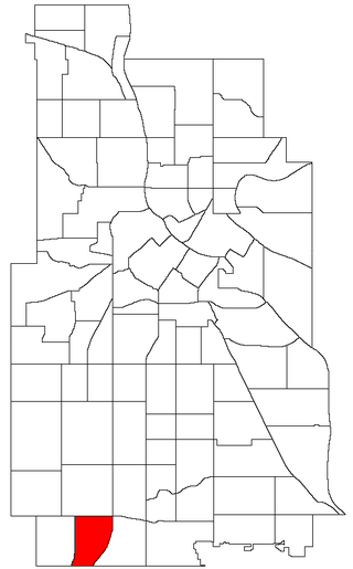
Kenny is a neighborhood in the Southwest community in Minneapolis. Its boundaries are West 54th Street to the north, Lyndale Avenue South and Highway 121 to the east, West 62nd Street to the south, and Logan Avenue South to the west. Kenny is a part of Ward 13, currently represented by Minneapolis City Council member Linea Palmisano.
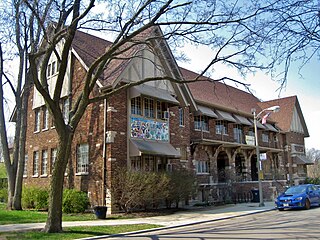
East Sacramento is a neighborhood in Sacramento, California, United States, that is east of downtown and midtown. East Sacramento is bounded by U.S. Route 50 to the south, Business Loop 80 to the west and north, Elvas Avenue to the northeast and east, and California State University, Sacramento and the American River to the southeast. East Sacramento residential development began in the 1890s, and the area was annexed into Sacramento in 1911. East Sacramento was also home to the Alhambra Theatre. East Sacramento also includes McKinley Park and the "Fabulous Forties" neighborhood.
Del Paso Heights is a neighborhood within the city of Sacramento in Sacramento County, California, United States. The generally recognized borders of Del Paso Heights consist of the Beltline Freeway Interstate 80 on the north, Norwood Avenue on the west, Arcade Creek on the south, and Roseville Road on the east. Del Paso Heights is located in Area 4 of Sacramento which is defined as the city north of the American River.
Robla is a neighborhood located within the city of Sacramento, California, United States. The borders of Robla are generally considered to be city limits on the north adjacent to Rio Linda, McClellan Park on the east, the Beltline Freeway Interstate 80 on the south, and Northgate Boulevard on the west. Robla was part of the "Unincorporated place" of Robla, which recorded a population of 11,495 in 1960.
Valley View Acres is a neighborhood located within the city of Sacramento, California. The neighborhood is located south of East Levee Road, north of Sotnip Road/Del Paso Road, west of Steelhead Creek and UEDA Parkway, and east of Sorento Road.
Midtown Sacramento is a historical district and neighborhood just east of Downtown Sacramento. Officially, Midtown's borders are R Street on the South, J Street on the North, 16th Street on the West and 30th Street on the East. However, the streets in Sacramento's original "grid" that are east of 16th Street cover the area commonly called "Midtown". This more general definition covers an area bounded by Broadway on the South, C street and the Southern Pacific rail lines on the North, 16th Street on the West and Alhambra Boulevard on the East.
Gardenland is a neighborhood in the city of Sacramento, California, around the Natomas Basin. It borders Northgate Boulevard to the west, Indiana Avenue to the north, Steelhead Creek to the east, and the Arden-Garden Connector to the south. It is the richest agricultural area within city limits.
North Sacramento is a community that is part of the city of Sacramento, California, United States. It was a city from its incorporation in 1924 until it was merged in 1964 into the City of Sacramento. Incorporation was led by the North Sacramento Chamber of Commerce, incorporated the year before, in 1923.
Arden Way is a major east-west arterial in Sacramento County, California, United States. It is approximately 8 miles (13 km) long and runs through Sacramento and the unincorporated suburbs of Arden-Arcade and Carmichael.
Upper Land Park is a neighborhood in the more general Land Park area of Sacramento, California which is referred to by the city as Area 2. It is located near the junction of U.S. Route 50 and Interstate 5. Its boundaries are officially Broadway to the north, Swanston Drive to the south, Riverside Boulevard to the east, and I-5 to the west.
Swanston Estates is a neighborhood situated in North Sacramento, California. It is bordered by Arden Way on the south, Ethan Way on the East, Business 80 on the west, and El Camino Avenue on the north. This area lies behind the Arden Fair Mall. The zip code for the neighborhood is 95815.

Brannan Island is a small island in the Sacramento–San Joaquin River Delta. It is part of Sacramento County, California, and is managed by Reclamation District 2067. Its coordinates are 38°07′19″N121°38′37″W, and the United States Geological Survey measured its elevation as −13 ft (−4.0 m) in 1981. A "Brannan Island", with the same location but a slightly different shape, is labeled on an 1850 survey map of the San Francisco Bay area made by Cadwalader Ringgold as well as an 1854 map of the area by Henry Lange.
