Sacramento is the capital city of the U.S. state of California and the county seat of Sacramento County. Located at the confluence of the Sacramento and American Rivers in Northern California's Sacramento Valley, Sacramento's 2020 population of 524,943 makes it the fourth-most populous city in Northern California, sixth-most populous city in the state, and the ninth-most populous state capital in the United States. Sacramento is the seat of the California Legislature and the Governor of California.
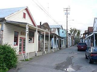
Locke, also known as Locke Historic District, is an unincorporated community in the Sacramento–San Joaquin River Delta of California, United States. The 14-acre town (5.7 ha) was first developed between 1893 and 1915 approximately one mile north of the town of Walnut Grove in Sacramento County.

Pico-Union is a neighborhood in Central Los Angeles, California. The name "Pico-Union" refers to the neighborhood that surrounds the intersection of Pico Boulevard and Union Avenue. Located immediately west of Downtown Los Angeles, it is home to over 40,000 residents.

The Dundee–Happy Hollow Historic District is located west of Midtown Omaha, Nebraska. It covers the area between Harney Street on the south, Hamilton Street on the north, Happy Hollow Boulevard on the west, and 46th Street on the east. The "heart" of Dundee is located at 50th and Underwood Avenue in Omaha, Nebraska, United States. It was founded in 1880 and annexed into the city in 1915. Dundee is home to Warren Buffett and nationally syndicated editorial cartoonist Jeff Koterba and was the hometown of filmmaker Alexander Payne. Actor Henry Fonda additionally lived in the Dundee neighborhood.

Boulevard Oaks is a neighborhood in Houston, Texas, United States, containing 21 subdivisions north of Rice University and south of U.S. Highway 59. Developed primarily during the 1920s and 1930s, Boulevard Oaks contains two National Register historic districts, Broadacres and Boulevard Oaks. The Boulevard Oaks Civic Association (BOCA) is the common civic association for all 21 subdivisions.
Elmhurst is a historic residential neighborhood located in the eastern part of Sacramento, California. Elmhurst is known for its large elm, ash, and oak trees that provide shady canopy for the neighborhood.

Neighborhoods in Spokane, Washington are officially grouped by the Spokane City Council into three main city council districts: 1, 2, and 3. Each city council district contains multiple, official neighborhoods that are recognized with a neighborhood council. Informally, neighborhoods are colloquially grouped by local geographical, geological, cultural, or historical features The list of neighborhoods below is organized based on the official designations by the City of Spokane. Unofficial neighborhoods and districts are listed within the official neighborhood in which they are located.
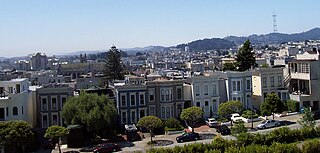
East Sacramento is a neighborhood in Sacramento, California, United States, that is east of downtown and midtown. East Sacramento is bounded by U.S. Route 50 to the south, Business Loop 80 to the west and north, Elvas Avenue to the northeast and east, and California State University, Sacramento and the American River to the southeast. East Sacramento residential development began in the 1890s, and the area was annexed into Sacramento in 1911. East Sacramento was also home to the Alhambra Theatre. East Sacramento also includes McKinley Park and the "Fabulous Forties" neighborhood.
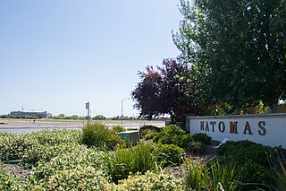
Natomas is a community in the northwestern section of the city of Sacramento, in the U.S. state of California.

The Upper Eastside is a neighborhood in Miami, Florida. It is north of Edgewater, east of Little Haiti, south of the village of Miami Shores, and sits on Biscayne Bay. In geographical order from south to north and east to west, it contains the subdivisions of Magnolia Park, Bay Point, Morningside, Bayside, Belle Meade, Shorecrest, and Palm Grove. The MiMo District along Biscayne Boulevard in the area is host to many art galleries, shops and restaurants.

Oak Park is a neighborhood in Sacramento, California. The McGeorge School of Law, University of the Pacific Sacramento Campus, Sacramento High School, and Christian Brothers High School are located in this neighborhood.

The Arden Park–East Boston Historic District is a neighborhood located in Detroit, Michigan, bounded on the west by Woodward Avenue, on the north by East Boston Boulevard, on the east by Oakland Avenue, and on the south by Arden Park Boulevard. The area is immediately adjacent to the much larger and better-known Boston-Edison Historic District, which is on the west side of Woodward Avenue, and also close to the Atkinson Avenue which is just south of Boston-Edison. There are 92 homes in the district, all on East Boston or Arden Park Boulevards. Arden Park Boulevard and East Boston Boulevard feature prominent grassy medians with richly planted trees and flowers. The setbacks of the homes are deep, with oversized lots. The district was listed on the National Register of Historic Places in 1982.

The Boston–Edison Historic District is a neighborhood located in Detroit, Michigan. It consists of over 900 homes built on four east-west streets: West Boston Boulevard, Chicago Boulevard, Longfellow Avenue and Edison Avenue, stretching from Woodward Avenue in the east to Linwood Avenue in the west. It is one of the largest residential historic districts in the nation. It is surrounded by Sacred Heart Major Seminary to the west, the Arden Park-East Boston Historic District and the Cathedral of the Most Blessed Sacrament to the east, and the Atkinson Avenue Historic District to the south. The district was designated a Michigan State Historic Site in 1973 and listed on the National Register of Historic Places in 1975.

Broadway–Flushing is a historic district and residential subsection of Flushing, Queens, New York City. The neighborhood comprises approximately 2,300 homes. It is located between 155th and 170th Streets to the west and east respectively, and is bounded on the north by Bayside and 29th Avenues, and on the south by Northern Boulevard and Crocheron Avenue. Broadway–Flushing is listed on the National Register of Historic Places.

Tahoe Park is a neighborhood located within the city of Sacramento, California.
Southeast Village is a neighborhood located in Southeast Sacramento. Its boundaries are Lemon Hill Ave to the north, 65th St. Expy to the west, 53rd Ave to the south, along with Logan St and 75th St to the east.
Colonial Heights is a neighborhood in the southeast part of the City of Sacramento, California. An older neighborhood, established in 1910, it makes a fairly typical example of a turn of the century "Streetcar Suburb". Before cars and buses took over for transportation needs, it was built around the convenient and efficient electric streetcar service provided by the Central California Traction Company.

The Cranston–Geary House also known locally as the Bramson Home is a historic home listed on the National Register of Historic Places. The house is a Craftsman-style home designed by George Sellon, California's first state architect.

Rockwood is a neighborhood in Spokane, Washington. It is located on the south side of the city to the southeast of Downtown Spokane and expanding southeasterly from close to the city center. Its proximity to downtown makes it one of Spokane's older neighborhoods, with mature trees lining most of its streets. Due to its location on the hill leading up from the Spokane River Valley, the street grid breaks down in many places around Rockwood. The most notable of these is along the winding Rockwood Boulevard, which bends its way from the northwesternmost corner of the neighborhood through the center and across to the eastern border.
 Agricultural Park racetrack (1890s)