
Sacramento is the capital city of the U.S. state of California and the county seat of Sacramento County. Located at the confluence of the Sacramento and American Rivers in Northern California's Sacramento Valley, Sacramento's 2020 population of 524,943 makes it the fourth-most populous city in Northern California, sixth-most populous city in the state, and the ninth-most populous state capital in the United States. Sacramento is the seat of the California Legislature and the Governor of California.
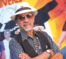
José Montoya was a poet and an artist from Sacramento, California. He was one of the most influential Chicano bilingual poets. He has published many well-known poems in anthologies and magazines, and served as Sacramento's poet laureate.
The Mission District, commonly known as the Mission, is a neighborhood in San Francisco, California. One of the oldest neighborhoods in San Francisco, the Mission District's name is derived from Mission San Francisco de Asís, built in 1776 by the Spanish. The Mission is historically one of the most notable centers of the city's Chicano/Mexican-American community.

The King & Story, also known as Story & King, neighborhood of San Jose, California is located in the Alum Rock district of East San Jose, centered on the intersection of King and Story roads. King & Story is one of San Jose's most notable and historic Chicano/Mexican-American neighborhoods.

Bernal Heights is a residential neighborhood in southeastern San Francisco, California. The prominent Bernal Heights hill overlooks the San Francisco skyline and features a microwave transmission tower. The nearby Sutro Tower can be seen from the Bernal Heights neighborhood.

Colegio Cesar Chavez was an American college-without-walls in Mount Angel, Oregon. The college was named after Mexican American civil rights activist César Chávez. Colegio was established in 1973 and closed in 1983. Colegio was the first accredited, independent four-year Chicano/Latino college in the United States. In 1975 it was granted candidacy status from the Northwest Association of Schools and Colleges. In 1977, Colegio granted degrees to 22 graduates, a number exceeding the combined number of Chicanos who graduated that same year from University of Oregon and Oregon State University. In his book Colegio Cesar Chavez, 1973–1983: A Chicano Struggle for Educational Self-Determination, author Carlos Maldonado writes that Colegio Cesar Chavez was one of the few institutions that was named after Cesar Chavez during his lifetime.
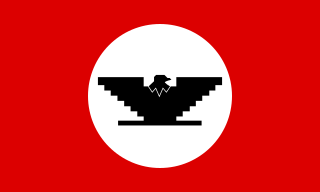
The Royal Chicano Air Force (RCAF) is a Sacramento, California-based art collective, founded in 1970 by Ricardo Favela, José Montoya and Esteban Villa. It was one of the "most important collective artist groups" in the Chicano art movement in California during the 1970s and the 1980s and continues to be influential into the 21st century.
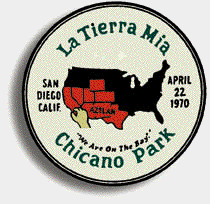
Chicano Park is a 32,000 square meter park located beneath the San Diego–Coronado Bridge in Barrio Logan, a predominantly Chicano or Mexican American and Mexican-migrant community in central San Diego, California. The park is home to the country's largest collection of outdoor murals, as well as various sculptures, earthworks, and an architectural piece dedicated to the cultural heritage of the community. Because of the magnitude and historical significance of the murals, the park was designated an official historic site by the San Diego Historical Site Board in 1980, and its murals were officially recognized as public art by the San Diego Public Advisory Board in 1987. The park was listed on the National Register of Historic Places in 2013 owing to its association with the Chicano Movement, and was designated a National Historic Landmark in 2016. Chicano Park, like Berkeley's People's Park, was the result of a militant people's land takeover. Every year on April 22, the community celebrates the anniversary of the park's takeover with a celebration called Chicano Park Day.

Barrio Logan is a neighborhood in south central San Diego, California. It is bordered by the neighborhoods of East Village and Logan Heights to the north, Shelltown and Southcrest to the east, San Diego Bay to the southwest, and National City to the southeast. Interstate 5 forms the northeastern boundary. The Barrio Logan Community Plan Area comprises approximately 1,000 acres, of which slightly more than half is under the jurisdiction of the Port of San Diego or the United States Navy rather than the city of San Diego. The community is subject to the California Coastal Act. Though located near the City's Central core, it has long been considered part of Southeast San Diego by many locals, being directly Southeast of Downtown, and with previous historical records labeling it as part of "Western Southeast San Diego."
Central Expressway is a north–south highway in the Dallas-Fort Worth Metroplex in Texas (USA) and surrounding areas. The best-known section is the North Central Expressway, a name for a freeway section of U.S. Highway 75 between downtown Dallas and Van Alstyne, Texas. The southern terminus is south of the Woodall Rodgers Freeway at exit 284C of "hidden" Interstate 345. From there, Central Expressway becomes the South Central Expressway, the northernmost portion of which was renamed César Chávez Boulevard on April 9, 2010.
Los Four was a Chicano artist collective active based in Los Angeles, California. The group was instrumental in bringing the Chicano art movement to the attention of the mainstream art world.
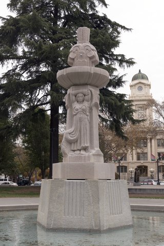
Cesar Chavez Plaza, or Cesar Chavez Park, is a city park in Sacramento, California, named after César Chávez. For more than a century the downtown square has been a focal point for community activities, including the Farmers' Market, music concerts, and community rallies.

The Chicano Art Movement represents groundbreaking movements by Mexican-American artists to establish a unique artistic identity in the United States. Much of the art and the artists creating Chicano Art were heavily influenced by Chicano Movement which began in the 1960s.
Josephine "Josie" Talamantez is a historian from San Diego, California. She co-founded Chicano Park in 1970 and helped develop it into a cultural National Historic Landmark containing the largest collection of artistic murals in the United States. Talamantez was also the Chief of Programs for the California Arts Council, served as the director of the Centro Cultural de la Raza, and was on the board of the National Association of Latino Arts and Culture.
Lorraine Garcia-Nakata is an American artist who works with various mediums including pastel, charcoal, ceramics, printmaking, installation, sculpture, and paint. Her work surrounds themes of the daily life, portraiture, and realism and is known for her large scale artworks. She is a member of the Royal Chicano Air Force (RCAF) artist collective since 1974.
Juanishi Orosco (1945-2023) is an American artist. He is known for his prints and murals associated with the Chicano Movement. He is a member and co-founder of the Royal Chicano Air Force art collective. Major American art museums hold Orosco's work in their collections, such as the Smithsonian American Art Museum, and murals by Orosco may be found across California.

Santa Rita Center, or Santa Rita Hall, is an unoccupied church hall at 10th Street and Hadley Roads, which was placed on the Phoenix Historic Property Register in October 2007, which has the same eligibility criteria as the National Register of Historic Places. It is one of three church halls stemming from the three chapels of the Historic Sacred Heart Church. It was purchased by the Chicanos Por La Causa, non-profit organisation, in 2004 for $71,000.

Mayfair is a neighborhood of San Jose, California, located in the Alum Rock district of East San Jose. It is one of San Jose's most historic Chicano/Mexican-American districts and noted for being a center of the Chicano Movement and grassroots activists like Californian civil rights leader César Chávez.

A Chicano mural is an artistic expression done, most commonly, on walls or ceilings by Chicanos or Mexican-American artists. Chicano murals rose during the Chicano art movement, that began in the 1960, with the influence of Mexican muralism and the Mexican Revolution. The murals are an illustration of Chicano’s ethnic pride or a form of activism against police brutality, social issues, political issues, and civil rights issues. It started being done by young Chicano artists in commonly marginalized neighborhoods, schools, and churches, demonstrating cultural art and ideas. The murals are characterized by their art style of bright color, religious symbols, and cultural references to Mexican and Mexican American history. Chicano murals have been and are historically found in the Southwest states like Texas, Colorado, and most famously, California, where the national landmark Chicano Park is located. The popularity of the Chicano Murals has allowed a sense of community, culture, activism, and storytelling about elements of being Chicano. Various states are currently looking to preserve and restore some murals as they carry historical meaning for the geographical community and the Mexican-American community.
