
Arden-Arcade is a census-designated place (CDP) in Sacramento County, California, United States. The population was 94,659 at the 2020 census, making it the second most populous census-designated place in California. It is east of the city of Sacramento and west of the community of Carmichael.

Carmichael is a census-designated place (CDP) in Sacramento County, California, United States. It is an unincorporated suburb in the Greater Sacramento metropolitan area. The population was 79,793 at the 2020 census.
Fair Oaks is a census-designated place (CDP) in Sacramento County, California, United States. It is part of the Sacramento–Arden-Arcade–Roseville Metropolitan Statistical Area. The population was 32,514 at the 2020 census, up from 30,912 at the 2010 census. The Fair Oaks zip code is 95628 and its area codes are 916 and 279. It is bordered to the west by Carmichael, north by the city of Citrus Heights, to the east by Orangevale, and to the south by the American River.

Rio Linda is a census-designated place (CDP) in Sacramento County, California, United States. It is part of the Sacramento metropolitan area. As of the 2010 census, the CDP population was 15,106, up from 10,466 at the time of the 2000 census.

The Richmond District is a neighborhood in the northwest corner of San Francisco, California, developed initially in the late 19th century. It is sometimes confused with the city of Richmond, which is 20 miles (32 km) northeast of San Francisco; accordingly, the neighborhood usually is referred to as "the Richmond."

Pocket-Greenhaven is a suburban community within the city of Sacramento, California, 5 miles south of downtown Sacramento. It is bordered by Interstate 5 on the east and a semi-circular "pocket" bend in the Sacramento River on the south, west, and north. The three exits into the Pocket-Greenhaven community off Interstate 5 are 43rd Avenue, Florin Road, and Pocket/Meadowview Road. Entering the area from the South on Interstate 5, travelers pass a landmark water tower with the words "Welcome to SACRAMENTO AMERICA'S FARM-TO-FORK CAPITAL" painted on it, marking the southern boundary of the city of Sacramento. The water tower was originally blank and looked very much like a spaceship alongside wheat and barley fields. Pocket-Greenhaven is located in the 95831 ZIP code.
California's 9th congressional district is a congressional district in the U.S. state of California. Josh Harder, a Democrat, has represented the district since January 2023.
California's 6th congressional district is a congressional district in the U.S. state of California. It is represented by Democrat Ami Bera.
Elmhurst is a historic residential neighborhood located in the eastern part of Sacramento, California. Elmhurst is known for its large elm, ash, and oak trees that provide shady canopy for the neighborhood.
California's 7th congressional district is a United States congressional district in California. Doris Matsui, a Democrat, has represented the district since January 2023.
Sacramento City Unified School District (SCUSD) is a public school system in Sacramento, California. With 47,900 students in 81 schools, it is the eleventh largest school district in California.

California's 45th congressional district is a congressional district in the U.S. state of California currently represented by Democrat Derek Tran.

Illinois's 6th congressional district covers parts of Cook and DuPage counties. It has been represented by Democrat Sean Casten since 2019.
East Sacramento is a neighborhood in Sacramento, California, United States, that is east of downtown and midtown. East Sacramento is bounded by U.S. Route 50 to the south, Business Loop 80 to the west and north, Elvas Avenue to the northeast and east, and California State University, Sacramento and the American River to the southeast. East Sacramento residential development began in the 1890s, and the area was annexed into Sacramento in 1911. East Sacramento was also home to the Alhambra Theatre. East Sacramento also includes McKinley Park and the "Fabulous Forties" neighborhood.
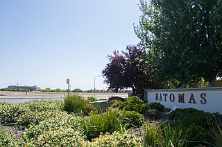
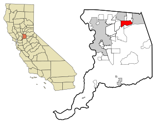
Natomas is a community in the northwestern section of the city of Sacramento, in the U.S. state of California.
Thompson is a primarily residential community in San Antonio, Texas. The neighborhood is 6 miles (9.7 km) west of Downtown San Antonio located between U.S. Highway 90 and Port San Antonio, with the Union Pacific railroad tracks and Lackland AFB servings as its east and west boundaries, respectively. Thompson is a collection of individual residential areas that were developed independently over a wide span of time. The area is the gateway to Port San Antonio and saw heaviest development during the 1940s, 50s and 60s. Many residents and families in the community were once stationed at or otherwise employed at the former Kelly AFB which gives the area its strong working-class and military tradition.
Land Park is a neighborhood in the city of Sacramento. Land Park consists of mainly single-family dwellings in the area between Interstate 5 to the west, Broadway to the north, Sutterville Road to the south and Freeport Blvd to the east. William Land Park is its namesake, a major city park south of Highway 50 and east of Interstate 5 in South Sacramento. It also contains the Sacramento Zoo along with the popular children's theme parks Funderland and Fairy Tale Town. In addition, Land Park is the home to the popular Vic's Ice Cream, Masullo Pizza, Tower Cafe, and Tower Theater. Katie Valenzuela is the city councilmember for District 4, which includes the entire Land Park area.
North Sacramento is a community that is part of the city of Sacramento, California, United States. It was a city from its incorporation in 1924 until it was merged in 1964 into the City of Sacramento. Incorporation was led by the North Sacramento Chamber of Commerce, incorporated the year before, in 1923.
Boulevard Park is a historic residential neighborhood in Sacramento, California. It is also the Boulevard Park Historic District, listed on the National Register of Historic Places.
Southside Park is a neighborhood in Sacramento, California, located immediately south of Downtown Sacramento. Its official borders are R Street to the north, W-X Freeway to the south, I-5 to the west, and 12th Street to the east.
