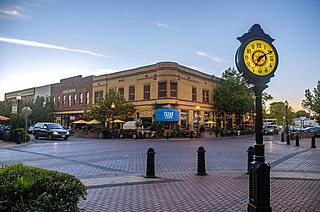
Winters is a city in rural Yolo County, and the western Sacramento Valley, in northern California.
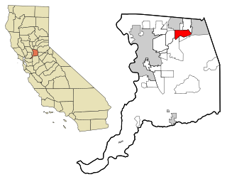
Fair Oaks is a census-designated place (CDP) in Sacramento County, California, United States. It is part of the Sacramento–Arden-Arcade–Roseville Metropolitan Statistical Area. The population was 32,514 at the 2020 census, up from 30,912 at the 2010 census. The Fair Oaks zip code is 95628 and its area codes are 916 and 279. It is bordered to the west by Carmichael, north by the city of Citrus Heights, to the east by Orangevale, and to the south by the American River.

The climate of Chicago is classified as hot-summer humid continental with hot humid summers and cold, occasionally snowy winters. All four seasons are distinctly represented: Winters are cold and often see snow with below 0 Celsius temperatures and windchills, while summers are warm and humid with temperatures being hotter inland, spring and fall bring bouts of both cool and warm weather and fairly sunny skies. Annual precipitation in Chicago is moderate and relatively evenly distributed, the driest months being January and February and the wettest July and August. Chicago's weather is influenced during all four seasons by the nearby presence of Lake Michigan.
The climate of Salt Lake City, Utah features cold and snowy winters, hot and dry summers, and modest to light seasonal rainfall. Lying in the Salt Lake Valley, the city is surrounded by mountains and the Great Salt Lake. Under the Köppen climate classification, Salt Lake City has either a Mediterranean climate (Csa) or dry-summer continental climate (Dsa) depending on which variant of the system is used, though it borders on a cold semi-arid climate (BSk) due to the city's relatively low precipitation.

Louisville is a city in Jefferson County, in the U.S. state of Kentucky. It is located at the Falls of the Ohio River.

The climate of Minneapolis–Saint Paul is the long term weather trends and historical events of the Minneapolis–Saint Paul metropolitan area in east central Minnesota. Minneapolis and St. Paul, together known as the Twin Cities, are the core of the 15th largest metropolitan area in the United States. With a population of 3.6 million people, the region contains approximately 60% of the population of Minnesota. Due to its location in the northern and central portion of the U.S., the Twin Cities has the coldest average temperature of any major metropolitan area in the nation. Winters are very cold, summer is warm and humid, snowfall is common in the winter and thunderstorms with heavy rainfall occur during the spring, summer and autumn. Though winter can be cold, the area receives more sunlight hours in mid-winter than many other warmer parts of the country, including all of the Great Lakes states, the Pacific Northwest, parts of the South, and almost all of the Northeast. Unless otherwise indicated, all normals data presented below are based on data at Minneapolis/St. Paul International Airport, the official Twin Cities climatology station, from the 1981−2010 normals period.
The climate of Bismarck in the U.S. state of North Dakota is humid continental, caused primarily by the combination of its mid-level latitude and location not far from the geographic centre of the U.S. Its summers are hot enough for it to border on having a Köppen Dwa classification, and precipitation is high enough for it to barely avoid being classified as semi-arid. The city's climate displays four very distinct seasons and great variation in temperatures over very short periods of time. Like other cities in the northern Great Plains, its climate is also fairly dry.
Milwaukee has a humid continental climate, with four distinct seasons and wide variations in temperature and precipitation in short periods of time. The city's climate is also strongly influenced by nearby Lake Michigan, which creates two varying climates within the Milwaukee area. The Urban heat island effect also plays a role in the city's climate, insulating it from winter cold, but keeping it cooler in spring and summer.

The City and County of Denver, Colorado, is located at 39°43'35" North, 104°57'56" West in the Colorado Front Range region. The Southern Rocky Mountains lie to the west of Denver and the High Plains lie to the east.

The climate of California varies widely from hot desert to alpine tundra, depending on latitude, elevation, and proximity to the Pacific Coast. California's coastal regions, the Sierra Nevada foothills, and much of the Central Valley have a Mediterranean climate, with warmer, drier weather in summer and cooler, wetter weather in winter. The influence of the ocean generally moderates temperature extremes, creating warmer winters and substantially cooler summers in coastal areas.
The climate of San Diego, California is classified as a temperate semi arid. The basic climate features hot, sunny, and dry summers, and cooler, wetter winters. However, San Diego is much more arid than typical Mediterranean climates, and winters are still dry compared with most other zones with this type of climate. The climate at San Diego International Airport, the location for official weather reports for San Diego, as well as the climate at most beach areas, straddles the border between BSh and BSk due to the mild winters and cool summers in these locations.
The climate of Houston is classified as a humid subtropical climate, with tropical influences. August normally ranks as the warmest month at 84.6 °F (29.2 °C) and January the coldest month at 53.1 °F (11.7 °C).

North Dakota's climate is typical of a continental climate with cold winters and warm-hot summers. The state's location in the Upper Midwest allows it to experience some of the widest variety of weather in the United States, and each of the four seasons has its own distinct characteristics. The eastern half of the state has a humid continental climate with warm to hot, somewhat humid summers and cold, windy winters, while the western half has a semi-arid climate with less precipitation and less humidity but similar temperature profiles. The areas east of the Missouri River get slightly colder winters, while those west of the stream get higher summer daytime temperatures. In general, the diurnal temperature difference is prone to be more significant in the west due to higher elevation and less humidity.
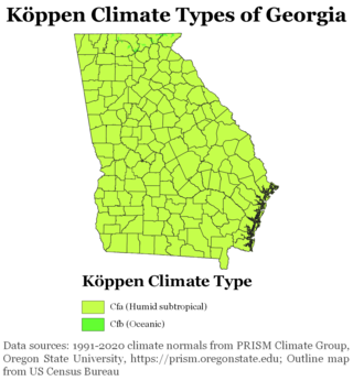
The climate of Georgia is a humid subtropical climate, with most of the state having short, mild winters and long, hot summers. The Atlantic Ocean on the east coast of Georgia and the hill country in the north impact the state's climate. Also, the Chattahoochee River divides Georgia into separate climatic regions with the mountain region to the northwest being cooler than the rest of the state; the average temperatures for the mountain region in January and July are 39 °F (4 °C) and 78 °F (26 °C) respectively. Winter in Georgia is characterized by mild temperatures and little snowfall around the state, with the potential for snow and ice increasing in the northern parts of the state. Summer daytime temperatures in Georgia often exceed 95 °F (35 °C). The state experiences widespread precipitation. Tornadoes and tropical cyclones are common.

The Climate of Illinois describes the weather conditions, and extremes, noted within the state of Illinois, United States, over time.

The climate of Los Angeles is mild to hot year-round, and mostly dry. It is classified as a Mediterranean climate, which is a type of dry subtropical climate. It is characterized by seasonal changes in rainfall—with a dry summer and a winter rainy season. Under the modified Köppen climate classification, the coastal areas are classified as Csb, and the inland areas as Csa.
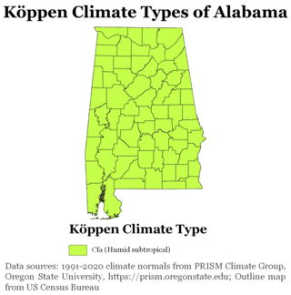
The state of Alabama is classified as humid subtropical (Cfa) under the Köppen climate classification. The state's average annual temperature is 64 °F (18 °C). Temperatures tend to be warmer in the state's southern portion with its proximity to the Gulf of Mexico, while its northern portions, especially in the Appalachian Mountains in the northeast, tend to be slightly cooler. Alabama generally has hot, humid summers and mild winters with copious precipitation throughout the year. The state receives an average of 56 inches (1,400 mm) of rainfall each year and experiences a lengthy growing season of up to 300 days in its southern portion. Hailstorms occur occasionally during the spring and summer here, but they are seldom destructive. Heavy fogs are rare, and they are confined chiefly to the coast. Thunderstorms also occur year-around. They are most common in the summer, but they are most commonly severe during the spring and late autumn. That is when destructive winds and tornadoes occur frequently, especially in the northern and central parts of the state. Central and northern Alabama are squarely within Dixie Alley, the primary area in the U.S. outside the Southern Plains with relatively high tornado risk. Alabama is ranked second in the U.S for the deadliest tornadoes. Hurricanes are quite common in the state, especially in the southern part. Major hurricanes occasionally strike the coast, such as Hurricane Frederic in September 1979 and Hurricane Ivan in September 2004; both storms resulted in significant to devastating damage in the Mobile area.

According to the Köppen climate classification, most of Western Oregon has a warm-summer Mediterranean climate, which features warm, dry summers, and wet winters with frequent overcast and cloudy skies. Eastern Oregon falls into the cold semi-arid climate, which features drier weather.
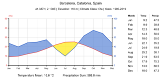
Barcelona has a maritime Mediterranean climate Csa according to Köppen-Geiger classification, a warm-temperate subtropical climate according to Troll-Paffen climate classification, and a subtropical climate according to Siegmund/Frankenberg climate classification.

The climate of Seattle is temperate, classified in the Warm-Summer (in contrast to Hot-Summer) subtype of the Mediterranean zone by the most common climate classification although some sources put the city in the oceanic zone. It has cool, wet winters and mild, relatively dry summers, covering characteristics of both. The climate is sometimes characterized as a "modified Mediterranean" climate because it is cooler and wetter than a "true" Mediterranean climate, but shares the characteristic dry summer and the associated reliance upon cooler-season precipitation. The city and environs are part of USDA hardiness zone 8b, with isolated coastal pockets falling under 9a.
