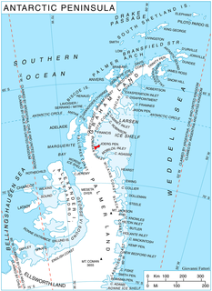
Alexander Island, which is also known as Alexander I Island, Alexander I Land, Alexander Land, Alexander I Archipelago, and Zemlja Alexandra I, is the largest island of Antarctica. It lies in the Bellingshausen Sea west of Palmer Land, Antarctic Peninsula from which it is separated by Marguerite Bay and George VI Sound. George VI Ice Shelf entirely fills George VI Sound and connects Alexander Island to Palmer Land. The island partly surrounds Wilkins Sound, which lies to its west. Alexander Island is about 390 kilometres (240 mi) long in a north-south direction, 80 kilometres (50 mi) wide in the north, and 240 kilometres (150 mi) wide in the south. Alexander Island is the second largest uninhabited island in the world, after Devon Island.
Weber Inlet is a broad ice-filled inlet, which indents the south part of the Beethoven Peninsula, lying southwest of Bennett Dome, forming the northwest arm of Bach Ice Shelf in the southwest portion of Alexander Island, Antarctica. The inlet was first mapped from air photos taken by the Ronne Antarctic Research Expedition in 1947–48, by Searle of the Falkland Islands Dependencies Survey in 1960, and named by the UK Antarctic Place-Names Committee after Carl Maria von Weber (1786–1826), a German composer.
Ives Ice Rise is an ice rise about 1 mile (1.6 km) long at the head of Weber Inlet, an ice-filled inlet situated between Bennett Dome and Berlioz Point on the Beethoven Peninsula, situated in the southwest part of Alexander Island, Antarctica. It was mapped by the United States Geological Survey from U.S. Navy aerial photographs taken 1967–68 and Landsat imagery taken 1972–73. In association with the names of composers grouped in this area, it was named by the Advisory Committee on Antarctic Names after Charles Ives, the American composer.
Boccherini Inlet is an ice-filled inlet, 18 nautical miles (33 km) long and 16 nautical miles (30 km) wide, lying between Bennett Dome and Shostakovich Peninsula, which indents the south side of Beethoven Peninsula and forms the northern extremity of the Bach Ice Shelf in Alexander Island. It was first mapped from air photos taken by the Ronne Antarctic Research Expedition, 1947–48, by D. Searle of the Falkland Islands Dependencies Survey in 1960, and named by the UK Antarctic Place-Names Committee for Luigi Boccherini, the Italian composer.
Delius Glacier is a glacier, 6 nautical miles (11 km) long and 2 nautical miles (4 km) wide, flowing west from the Elgar Uplands into Nichols Snowfield, in the northern part of Alexander Island, Antarctica. It was first seen from the air and roughly mapped by the British Graham Land Expedition in 1937. It was more accurately mapped from air photos taken by the Ronne Antarctic Research Expedition, 1947–48, by D. Searle of the Falkland Islands Dependencies Survey in 1960, and from U.S. Landsat imagery of February 1975. It was named by the UK Antarctic Place-Names Committee after Frederick Delius, the British composer.
Joerg Peninsula is a rugged, mountainous peninsula, 22 nautical miles (41 km) long in a northeast–southwest direction and from 3 to 10 nautical miles wide, lying between Trail Inlet and Solberg Inlet on the Bowman Coast of Graham Land, Antarctica. Its tip is indented by Hondius Inlet. The peninsula lies in the area explored from the air by Sir Hubert Wilkins in 1928 and Lincoln Ellsworth in 1935, and its south coast was mapped by W.L.G. Joerg from air photographs taken by Ellsworth. It was further mapped and photographed from the air by the United States Antarctic Service in 1940, and was surveyed by the Falkland Islands Dependencies Survey in 1947. The peninsula was named by the UK Antarctic Place-Names Committee after W.L.G. Joerg (1885–1952), who was an American geographer, polar cartographer, and archivist, and who made important contributions to Antarctic cartography, nomenclature and history. Joerg was Chairman of the United States Board on Geographic Names Special Committee on Antarctic Names, 1943–47, and was a member of the Advisory Committee on Antarctic Names, 1947–52.
Kosar Point is a snow-covered headland forming the westernmost extremity of the Eroica Peninsula, situated in the southwest portion of Alexander Island, Antarctica. it was photographed from the air by the Ronne Antarctic Research Expedition in 1947 and mapped from these photographs by the Falkland Islands Dependencies Survey in 1960. It was mapped by the United States Geological Survey from U.S. Navy aerial photographs taken 1967–68 and from Landsat imagery taken 1972–73. The point was named by the Advisory Committee on Antarctic Names for Commander William S. Kosar, U.S. Navy, assigned to the Division of Polar Programs, National Science Foundation, as aviation projects officer, 1975–77. He was instrumental in modifying LC-130 aircraft to provide longer range in support of extensive radio echo sounding missions.
Derocher Peninsula is a snow-covered peninsula between Brahms Inlet and Mendelssohn Inlet on the north side of Beethoven Peninsula, Alexander Island, Antarctica. It was photographed from the air by the Ronne Antarctic Research Expedition, 1947–48, and mapped from these photographs by D. Searle of the Falkland Islands Dependencies Survey (FIDS), 1960. It was named by the Advisory Committee on Antarctic Names after Commander Paul J. Derocher, U.S. Navy, Commanding Officer, Antarctic Development Squadron Six (VXE-6), May 1985 to May 1986. Derocher Peninsula is one of the eight peninsulas of Alexander Island.
Mount Grieg is a snow-covered mountain, rising to about 800 metres (2,600 ft), with a rock-exposed west face, overlooking the southeast part of Brahms Inlet and is situated on the base of the Derocher Peninsula, on the north side of the Beethoven Peninsula in the southwest part of Alexander Island, Antarctica. A number of mountains in this vicinity first appear on maps by the Ronne Antarctic Research Expedition (RARE), 1947–48. This mountain, apparently one of these, was mapped from RARE air photos by D. Searle of the Falkland Islands Dependencies Survey in 1960, and was remapped by the United States Geological Survey, 1988. It was named by the UK Antarctic Place-Names Committee after Edvard Grieg, the Norwegian composer.
Pesce Peninsula is a broad snow-covered peninsula lying between Rameau Inlet and Verdi Inlet on the north side of the Beethoven Peninsula, situated in the southwest portion of Alexander Island, Antarctica. Dykeman Point is the main and only headland on Pesce Peninsula marking the northern extremity of the peninsula. Photographed from the air by Ronne Antarctic Research Expedition (RARE), 1947–48, and mapped from these photographs by D. Searle of Falkland Islands Dependencies Survey (FIDS), 1960. Named by Advisory Committee on Antarctic Names (US-ACAN) for Commander Victor L. Pesce, U.S. Navy, Commanding Officer, U.S. Navy Antarctic Development Squadron Six (VXE-6), from May 1980 to May 1981. Pesce Peninsula is one of the eight peninsulas of Alexander Island.
Dykeman Point is a snow-covered point between Rameau Inlet and Verdi Inlet, marking the northwestern extremity of Pesce Peninsula on the Beethoven Peninsula, southwest Alexander Island, Antarctica. It was mapped by the United States Geological Survey from U.S. Navy aerial photographs taken 1967–68 and from Landsat imagery taken 1972–73. It was named by the Advisory Committee on Antarctic Names for Commander Paul R. Dykeman, U.S. Navy, Commanding Officer of Antarctic Development Squadron Six (VXE-6) from May 1981 to May 1982.
Eroica Peninsula is an ice-covered peninsula lying north of Beethoven Peninsula and Mendelssohn Inlet in western Alexander Island, Antarctica. The tip of the peninsula is Kosar Point, marking the western extremity of the Eroica Peninsula. It was mapped from trimetrogon air photography taken by the Ronne Antarctic Research Expedition, 1947–48, and from survey by the Falkland Islands Dependencies Survey, 1948–50. It was named by the UK Antarctic Place-Names Committee after Beethoven's Eroica symphony, in association with Beethoven Peninsula. Eroica Peninsula is one of the eight peninsulas of Alexander Island.
Gluck Peak is a rock peak, 335 metres (1,100 ft) high, located 6.5 nautical miles (12 km) south-southwest of Mount Borodin and immediately north of Alyabiev Glacier, lying between the bases of Bennett Dome and Shostakovich Peninsula on south side of the Beethoven Peninsula, southwest Alexander Island, Antarctica. It was first mapped from air photos taken by the Ronne Antarctic Research Expedition, 1947–48, by D. Searle of the Falkland Islands Dependencies Survey in 1960, and was named by the UK Antarctic Place-Names Committee after Christoph Willibald von Gluck, the Austrian composer (1714-1787).
Mendelssohn Inlet is an ice-filled inlet, 25 nautical miles (46 km) long and 9 nautical miles (17 km) wide, situated between Derocher Peninsula and Eroica Peninsula on the north side of Beethoven Peninsula, in the southwest part of Alexander Island, Antarctica. The inlet was first sighted from the air and roughly mapped by the United States Antarctic Service, 1939–41, and was resighted and photographed from the air by the Ronne Antarctic Research Expedition (RARE), 1947–48. It was remapped from the RARE photos by D. Searle of the Falkland Islands Dependencies Survey in 1960, and named by the UK Antarctic Place-Names Committee after German composer Felix Mendelssohn.
Hushen Glacier is a glacier lying at the southwestern part of the base of the Mendelssohn Inlet, an inlet lying between Derocher Peninsula and Eroica Peninsula indenting the north face of Beethoven Peninsula, in the southwestern portion of Alexander Island, Antarctica. The glacier flows northeast while joining Reuning Glacier which discharges into the south part of Mendelssohn Inlet. It was mapped by the United States Geological Survey from U.S. Navy aerial photographs taken 1967–68 and from Landsat imagery taken 1972–73, and was named by the Advisory Committee on Antarctic Names for W. Timothy Hushen, Director of the Polar Research Board at the National Academy of Sciences, 1981–88.
Mazza Point is a snow-covered headland lying between Brahms Inlet and Mendelssohn Inlet, marking the northwest end of Derocher Peninsula, a minor peninsula that extends in a northwest point from Beethoven Peninsula, situated in the southwest portion of Alexander Island, Antarctica. The headland was first mapped by the United States Geological Survey from U.S. Navy aerial photographs taken in 1967–68 and from U.S. Landsat imagery taken in 1972–73. It was named by the Advisory Committee on Antarctic Names for Commander Joseph D. Mazza, U.S. Navy, Commanding Officer of Squadron VXE-6, May 1986 to May 1987.
Schaus Ice Rises is a group of small ice rises merged within the Wilkins Ice Shelf, aligned east-west just off the north side of Eroica Peninsula, situated off the southwest coast of Alexander Island, Antarctica. Mapped by United States Geological Survey (USGS) from U.S. Navy aerial photographs taken 1967-68 and from Landsat imagery taken 1972-73. Named by Advisory Committee on Antarctic Names (US-ACAN) for Commander Richard Schaus, U.S. Navy, assigned to the Division of Polar Programs, National Science Foundation (NSF), as aviation projects officer, 1979-80.
Holoviak Glacier is a glacier flowing west into the head of Mendelssohn Inlet, facing towards the Wilkins Ice Shelf on the north side of the Beethoven Peninsula, lying in the southwestern portion of Alexander Island, Antarctica. It was mapped by the United States Geological Survey from U.S. Navy aerial photographs taken 1967–68 and from Landsat imagery taken 1972–73, and was named by the Advisory Committee on Antarctic Names for Judy C. Holoviak, technical editor, 1964–77, of the Antarctic Research Series, published by the American Geophysical Union, and director of publications for the Union from 1978.
Reuning Glacier is a glacier situated on the north side of Beethoven Peninsula, lying within the southwest portion of Alexander Island, Antarctica. The glacier flows in a northwest direction and joins Hushen Glacier in discharging into south Mendelssohn Inlet. The glacier was first mapped by the United States Geological Survey (USGS) from U.S. Navy aerial photographs taken 1967-68 and U.S. Landsat imagery taken 1972-73. Named by Advisory Committee on Antarctic Names (US-ACAN) for Winifred M. Reuning, Office of Polar Programs, National Science Foundation (NSF), Editor, Antarctic Journal of the United States, from 1980.