Bergosa

Last updated
Bergosa
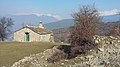
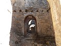
Abandoned settlement
Bergosa Pueblo abandonado HU Espana 3.jpg
Huesca-municipiosgrandesl.png
CountrySpain
Autonomous communityAragon
ProvinceHuesca
ComarcaJacetania
MunicipalityJaca
Elevation
1,128 m (3,701 ft)
Population
  Total0 (INE 2,019)

Bergosa is an unpopulated settlement belonging to the municipality of Jaca, in the region of Jacetania, province of Huesca, Aragon. It is part of the Garcipollera.

Contents

Toponymy

According to Agustín Ubieto, the first mention of the place dates from 948 or 962, in the work of his brother, Antonio Ubieto, Cartulario de San Juan de la Peña II, in Textos Medievales, 6 (Valencia, 1963) and documents the variations Bergossa, Bergosi, Bergasa, Uergosa, Uergossa and Bergosa. [1]

Geography

In 1966, the place was expropriated, as in the rest of the Garcipollera, in order to carry out an important reforestation of conifers on its slopes as a measure to retain the erosion caused by the construction of the Yesa Reservoir. [2]

Demographics

Locality

Demographic data on the town of Bergosa since 1900: [3] [4]

Historical population of Bergosa
Year19001910192019301940195019601970
Population60515959513631--

Former municipality

Demographic data of the municipality of Bergosa since 1842: [5]

Historical population of Bergosa
Year18421857186018771887189719001910
Population87--------------

Local holidays

See also

Related Research Articles

<span class="mw-page-title-main">Demographics of Spain</span>

As of 1 January 2020, Spain had a total population of 47,431,256, which represents a 0.9% increase since 2019. The modern Kingdom of Spain arose from the accretion of several independent Iberian realms, including the Kingdoms of León, Castile, Navarre, the Crown of Aragon and Granada, all of which, together with the modern state of Portugal, were successor states to the late antique Christian Visigothic Kingdom after the Reconquista.

<span class="mw-page-title-main">Benabarre</span> Municipality in Aragon, Spain

Benabarre, in Ribagorçan and Aragonese: Benavarri is a town and municipality in the Aragonese comarca of Ribagorza, in the province of Huesca, Spain.

<span class="mw-page-title-main">Sesa, Spain</span> Municipality in Aragon, Spain

Sesa is a municipality located in the Hoya de Huesca comarca, province of Huesca, Aragon, Spain. According to the 2010 census the municipality has a population of 225 inhabitants. Its postal code is 22110.

<span class="mw-page-title-main">Alboraya</span> Municipality in Valencian Community, Spain

Alboraya or Alboraia is a town and municipality of the province of Valencia, Spain. It is situated very close to the city of Valencia.

<span class="mw-page-title-main">Ademuz</span> Municipality in Valencian Community, Spain

Ademuz is a municipality in the comarca of Rincón de Ademuz in the Valencian Community, Spain. The name in Valencian is Ademús, but the local language is Spanish, not Valencian.

<span class="mw-page-title-main">San Vicente del Valle</span> Municipality and hamlet in Castile and León, Spain

San Vicente del Valle is a municipality and hamlet located in the province of Burgos, Castile and León, Spain. The municipality is in the comarca of Sierra de la Demanda. In addition to the hamlet of San Vicente del Valle, since 1857 the municipality has included the hamlet of Espinosa del Monte.

Novales is a municipality located in the province of Huesca, Aragon, Spain. According to the 2004 census (INE), the municipality has a population of 191 inhabitants. It is situated on a plain on the right bank of the river Guatizalema, about 16 km Southeast of Huesca.

Santa Cilia is a municipality located in Jacetania, province of Huesca, Aragon, Spain. It is 14 km from the town of Jaca between the River Aragon and the national highway N-240.

<span class="mw-page-title-main">Abejuela</span> Place in Aragon, Spain

Abejuela is a municipality located in the province of Teruel, Aragon, Spain. According to the 2018 census (INE), the municipality has a population of 49 inhabitants. It is the southernmost town in Aragon.

<span class="mw-page-title-main">Cabra de Mora</span> Municipality in Aragon, Spain

Cabra de Mora is a municipality located in the province of Teruel, Aragon, Spain. According to the 2004 census (INE), the municipality had a population of 119 inhabitants. In 2018, only 55 inhabitants were living in the municipality, which has been experiencing a steady population decrease since 2007.

<span class="mw-page-title-main">Villarroya de los Pinares</span> Municipality in Aragon, Spain

Villarroya de los Pinares is a municipality located in the Maestrazgo region, province of Teruel, Aragon, Spain. According to the 2004 census (INE), the municipality had a population of 190 inhabitants.

<span class="mw-page-title-main">Aranda de Moncayo</span> Municipality in Aragon, Spain

Aranda de Moncayo is a municipality located in the province of Zaragoza, Aragon, Spain. According to the 2023 census (INE), the municipality has a population of 127 inhabitants. The municipality is home to the 12th-century Castle of Aranda de Moncayo.

<span class="mw-page-title-main">Sena, Aragon</span> Municipality in Aragon, Spain

Sena is a municipality located in the Monegros comarca province of Huesca, Aragon, Spain. According to the 2018 census, the municipality has a population of 489 inhabitants.

Isín is a locality belonging to the municipality of Sabiñánigo. In 2019, it had a population of 5 inhabitants. The populated place lies in the valley formed by the Aurín river, on its right bank, at about 1027 metres above sea level.

<span class="mw-page-title-main">Larrosa</span> Abandoned village in Jaca, Huesca Province, Spain

Larrosa is an unpopulated settlement and a former municipality of Spain, belonging to the present municipality of Jaca, in the comarca of Jacetania, province of Huesca, Aragon.

<span class="mw-page-title-main">Villanovilla</span> Settlement in Huesca Province, Aragon, Spain

Villanovilla is a Spanish settlement belonging to the municipality of Jaca, in the Jacetania, province of Huesca, Aragon.

<span class="mw-page-title-main">Bescós de Garcipollera</span> Settlement in province of Huesca, Aragon, Spain

Bescós de Garcipollera or Bescós de la Garcipollera is a Spanish settlement belonging to the municipality of Jaca, in the Jacetania, province of Huesca, Aragon. It is located in the valley of the Garcipollera.

<span class="mw-page-title-main">Acín</span> Abandoned village in Huesca Province, Aragon, Spain

Acín is an unpopulated village in Spain, within the municipality of Jaca, in the province of Huesca. It is located in the valley of the Garcipollera, in the Aragonese region of the Jacetania.

<span class="mw-page-title-main">Yosa de Garcipollera</span> Inhabited village in Jacetania, Aragon, Spain

Yosa de Garcipollera is an abandoned town belonging to the municipality of Jaca, in the province of Huesca, in Spain. It is part of the Garcipollera Valley, in the region of Jacetania, in the autonomous community of Aragon.

<span class="mw-page-title-main">La Garcipollera</span> Valley in Jacetania, Huesca, Spain.

La Garcipollera, also known as Garcipollera Valley, is a small area of the Aragonese Pyrenees, within the Jacetania, in the province of Huesca, practically coinciding with the basin of the Ijuez river, a tributary of Aragon. It is characteristic because most of its villages were depopulated during the 20th century.

References

  1. Ubieto Arteta, Agustín (1972). Toponimia aragonesa medieval (in Spanish). Valencia: Anubar. p. 57.
  2. "BERGOSA - PARROQUIAL DE SAN SATURNINO-Rutas romanicas por el altoaragon-A.Garcia Omedes". www.arquivoltas.com (in Spanish). Retrieved 2022-07-12.
  3. Instituto Aragonés de Estadística (2005). Catálogo de pueblos y municipios de Aragón. Estadística de población y nomenclaturas toponímicas entre 1900 y 2004 (in Spanish) (1st ed.). Zaragoza: Gobierno de Aragón. pp. 72–73. ISBN   84-7753-366-0.
  4. Nomenclature: Population of the Continuous Register by Population Unit. INE - Spanish National Statistics Institute. (in Spanish)
  5. Alterations of the municipalities in the Population Censuses since 1842. INE - National Institute of Statistics of Spain. (in Spanish)

42°36′54″N0°32′12″W / 42.61500°N 0.53667°W / 42.61500; -0.53667