
Ayerbe is a town in the Hoya de Huesca comarca, in the autonomous community of Aragon in Spain.

Villanúa is a Pyrenean municipality in Spain in the north of Huesca province, in la Jacetania, set where the Aragon valley gets wider. Its name refers to the "new village" repopulated in the late 10th century. Villanúa's altitude is 953 m and it covers 58.2 km2. The village is at the bottom of mount Collarada and in 2018 had 447 inhabitants.

The Victor Valley is a valley in the Mojave Desert and subregion of the Inland Empire, in San Bernardino County in Southern California.
Astún is a ski resort situated near the town of Canfranc in the High Aragon of the western Pyrenees. The source of the Aragon River is in the resort. Ibón de Truchas attracts anglers. It is connected to the city by 33 km of the N -330. At his feet is the urbanization of the tracks, which had 6 inhabitants in 2012.

Majadahonda is a municipality in Spain, situated 16 km (9.9 mi) northwest of Madrid, in the Community of Madrid.
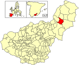
Benamaurel is a village located in the province of Granada, Spain. According to the 2006 census (INE), the city has a population of 2328 inhabitants. The municipality includes the following localities: Puente Arriba, San Marcos, Cuevas de la Blanca, Huerta Real, Cuevas del Negro y Cuevas de Luna. There is a market held every Sunday morning and a 3-day Moors and Christians festival held in April.

Sotragero is a municipality and town located in the province of Burgos, Castile and León, Spain. According to the 2007 census (INE), the municipality has a population of 230 inhabitants. Sotragero is 8 km north from Burgos, and it is a member of the Alfoz de Burgos in the valley of the Ubierna river.

San Andrés del Rabanedo is a municipality located in the Province of León, Castile and León, Spain. According to the 2011 census (INE), the city has a population of 31,562 inhabitants, and is the third largest city in the province after León and Ponferrada. The municipality includes the districts of San Andrés del Rabanedo, Trobajo del Camino, Barrio Pinilla, Villabalter and Ferral del Bernesga.
Villaquilambre is a municipality located in the Province of León, Castile and León, Spain. According to the 2007 census (INE), the municipality has a population of 15,597.

Cubillo del Campo is a municipality located in the province of Burgos, Castile and León, Spain.

Monterrubio de la Demanda is a municipality and village located in the province of Burgos, Castile and León, Spain.
Almudévar is an municipality of the province of Huesca.

Torla-Ordesa is a municipality in the province of Huesca, Aragon, Spain. It is in the northwest of the Sobrarbe region, 100 km from the capital of Huesca, and had 298 inhabitants according to the 2018 census (INE).
Piedratajada, is a municipality located in the province of Zaragoza, Aragon, Spain. According to the 2004 census (INE), the municipality has a population of 168 inhabitants.
Algodre is a municipality located in the province of Zamora, Castile and León, Spain. According to the 2004 census (INE), the municipality had a population of 181. It is north of Gallegos del Pan, south of Coreses and west of Molacillos.

The Bardenas Reales is a semi-desert natural region, or badlands, of some 42,000 hectares in southeast Navarre (Spain). The soils are made up of clay, chalk, and sandstone and have been eroded by water and wind creating surprising shapes, canyons, plateaus, tabular structures, and isolated hills, called cabezos. Bardenas Reales lacks urban areas, vegetation is scarce and the many streams that cross the territory have a markedly seasonal flow, staying dry most of the year.

Matanza de los Oteros is a municipality in the province of León, Spain. It has an area of 20.69 mi2 with a population of 179, as of 2017. It is about 28.58 mi south of the Leonese capital, León.
Tatatila is a municipality located in the mountainous central zone of the Mexican state of Veracruz, about 26 km from the state capital Xalapa. It has a surface area of 82.25 km2. It is located at 19°42′N97°07′W.
Tlaquilpa is a municipality located in the south zone in the Mexican state of Veracruz, about 105 km from the state capital of Xalapa. It has a surface of 58.40 km2. It is located at 18°36′N97°07′W. The name comes from Náhuatl, and means "bricklayers' place". Tlaquilpa is a very ancient village, which existed before the Spanish conquest. In the 16th century, it came under Zongolica's jurisdiction, with the name of Santa Maria Magdalena. In 1831 it was constituted as a municipality. Tlaquilpa borders on Mixtla de Altamirano, Astacinga and Texhuacán.

Fiscal is a municipality in the province of Huesca, Sobrarbe comarca, Aragon, Spain. It is located 76 kilometers from Huesca. It is 768 meters above sea level, and covers an area of 170 km2. As of 2018, it had a population of 327 inhabitants.


