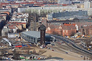
Kreuzberg is a district of Berlin, Germany. It is part of the Friedrichshain-Kreuzberg borough located south of Mitte. During the Cold War era, it was one of the poorest areas of West Berlin, but since German reunification in 1990, it has become more gentrified and is known for its arts scene.

Mitte is the first and most central borough of Berlin. The borough consists of six sub-entities: Mitte proper, Gesundbrunnen, Hansaviertel, Moabit, Tiergarten and Wedding.

Friedrichshain is a quarter (Ortsteil) of the borough of Friedrichshain-Kreuzberg in Berlin, Germany. From its creation in 1920 until 2001, it was a freestanding city borough. Formerly part of East Berlin, it is adjacent to Mitte, Prenzlauer Berg, Kreuzberg and Lichtenberg.

Karl-Marx-Allee is a boulevard built by the GDR between 1952 and 1960 in Berlin Friedrichshain and Mitte. Today the boulevard is named after Karl Marx. It should not be confused with the Karl-Marx-Straße in the Neukölln district of Berlin.

The Oberbaum Bridge is a double-deck bridge crossing Berlin, Germany's River Spree, considered one of the city's landmarks. It links Friedrichshain and Kreuzberg, former boroughs that were divided by the Berlin Wall, and has become an important symbol of Berlin's unity.

Platz der Luftbrücke is a Berlin U-Bahn station located on the U6. It is located under Platz der Luftbrücke and the south end of Mehringdamm on the border between Kreuzberg and Tempelhof, near the former Tempelhof International Airport, and is now named for the square there with its memorial to the victims of the Berlin Airlift.
The Greater Berlin Act, officially Law Regarding the Creation of the New Municipality of Berlin, was a law passed by the Prussian state government in 1920, which greatly expanded the size of the Prussian and German capital of Berlin.

Berlin Ostkreuz station is a station on the Berlin S-Bahn suburban railway and the busiest interchange station in Berlin. It is in the former East Berlin district of Friedrichshain, now part of the borough of Friedrichshain-Kreuzberg. A smaller part of the station is in Rummelsburg, part of the borough of Lichtenberg. The station is a Turmbahnhof with the Berlin–Frankfurt (Oder) railway and the Prussian Eastern Railway on the lower level and the Berlin Ringbahn on the upper level. It is used by a total of around 235,000 passengers every day on eight lines, entering or leaving.

Lichtenberg is a quarter (Ortsteil) of Berlin in the homonymous borough (Bezirk) of Lichtenberg. Until 2001 it was an autonomous district with the localities of Fennpfuhl, Rummelsburg, Friedrichsfelde and Karlshorst.

The Berlin Inner Ring road is a beltway route of major roads around the historic city centre of Berlin encompassing the boroughs of Mitte, Pankow and Friedrichshain-Kreuzberg. It is named "Inner Ring" to distinguish it from both the wider City Ring (Stadtring) road including the Bundesautobahn 100 sections and the outer Berlin Ring orbital motorway.

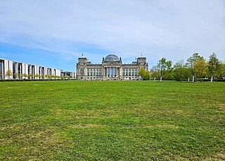
Platz der Republik is a square in Berlin, Germany. It is located in the Tiergarten, directly in front (west) of the Reichstag building. The square has an area of about 36,900 square meters and is almost completely covered by grass but is decorated with some hedges and a few trees.

The Embassy of France in Berlin is the diplomatic mission of the French Republic in Germany. Designed by Christian de Portzamparc and completed in 2002, it is at the same address, Pariser Platz 5, as the former embassy which was destroyed in World War II. Prior to German reunification, France had an embassy in the German Democratic Republic at a different address in Berlin and an embassy in the Federal Republic in Bonn.

The Mehringdamm is a street in southern Kreuzberg, Berlin. In the north it starts at Mehringbrücke and ends - with its southernmost houses already belonging to Tempelhof locality - on Platz der Luftbrücke. It is the historical southbound Berlin-Halle highway, now forming the federal route 96. The main junction of Mehringdamm is with the 19th-century ring road around Berlin's inner city, named Yorckstraße west, and Gneisenaustraße east of Mehringdamm.

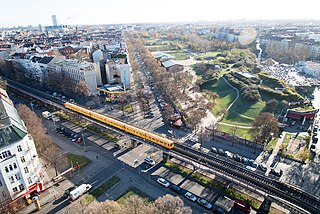
Görlitzer Park is a major park and recreation area in the Kreuzberg district of Berlin. The 14-hectare park area contains, among other things, a petting zoo, several sports and football fields, and a small lake. At its north-west end is the Görlitzer Bahnhof U-Bahn station.

The Berlin Stalin statue was a bronze portrayal of the Soviet leader Joseph Stalin. A Komsomol delegation had presented the sculpture to the East Berlin government on the occasion of the Third World Festival of Youth and Students in 1951. The monument was formally dedicated on 3 August 1951 after temporary placement at a location on a newly designed and impressive boulevard, Stalinallee, being constructed at the time in what was then the Berlin district of Friedrichshain. Stalin monuments were generally removed from public view by the leadership of the Soviet Union and other associated countries, including East Germany, during the period of De-Stalinization. In Berlin the statue and all street signs designating Stalinallee were hastily removed one night in a clandestine operation and the street was renamed Karl-Marx-Allee and Frankfurter Allee. The bronze sculpture was smashed and the pieces were recycled.

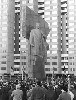
The Lenin Monument was a monument to Vladimir Lenin in East Berlin created by the Soviet Russian sculptor Nikolai Tomsky. It was inaugurated on April 19, 1970 to commemorate the 100th anniversary of Lenin's birth. After German reunification, the district council of Friedrichshain voted for its removal despite demonstrations and petitions from neighborhood residents and preservationists. The demolition process began in November 1991, and by February 1992 the monument was completely dismantled and its fragments buried on the outskirts of Berlin. In 2015, the head of the statue was excavated, and since 2016 it has been on display at Berlin’s Spandau Citadel as part of a permanent exhibition of Berlin political monuments.

Kollwitzplatz is a city square in the Berlin district of Prenzlauer Berg, district of Pankow. The square forms the center of the so-called "Kollwitzkiez". It was named, on 7 October 1947, after the German graphic artist and sculptor Käthe Kollwitz, who spent a large part of her life here in the house at Weissenburger Straße No. 25. Until then, it was called Wörther Platz; a name that was given to it when the area was planned for construction in 1875. Indirectly, this name is also a reminder of her husband Karl Kollwitz, who worked here as a physician until 1940 and thus shaped the area around the square independently of his wife. The triangular complex is bordered by Kollwitzstraße, Knaackstraße and Wörther Straße. In total, the square is about 6000 m2 in size.
The Berliner Abendblatt is the leading weekly advertising paper in Berlin, Germany alongside the Berliner Woche and, along with Einkaufaktuell, one of the three main media for the collective distribution of the weekly brochures of retail chains in Berlin.

Silvio Meier (1965–1992) was an East German activist and squatter who was killed by neo-Nazis in Berlin on 21 November 1992. After moving to East Berlin in 1986, Meier became involved in oppositional politics with the Church from Below. His death has been commemorated with an annual memorial march and the renaming of a street in the Berlin district of Friedrichshain.


