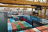
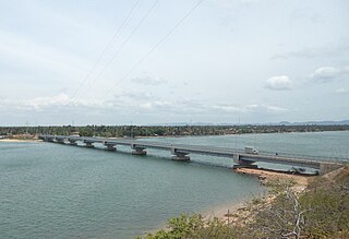
Beruwala Harbour, in Beruwala, Sri Lanka, is one of the main fishery harbours on the western coast of Sri Lanka. It is situated in the southern edge of the Kalutara district, which is about 60km south of Colombo. It has the capability of supplying berthing, refrigeration and fuel facilities which are often needed by fishing boats.
Beruwala is a town in Kalutara District, Western Province, Sri Lanka, governed by an Urban Council. Beruwala with a total area of approximately 15 square kilometres and is located on the south-west coast of Sri Lanka, 60 km (37 mi) south of Colombo.
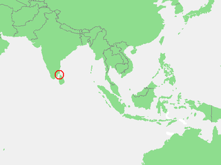
Sri Lanka, officially the Democratic Socialist Republic of Sri Lanka, is an island country in South Asia, located in the Indian Ocean to the southwest of the Bay of Bengal and to the southeast of the Arabian Sea. The island is historically and culturally intertwined with the Indian subcontinent, but is geographically separated from the Indian subcontinent by the Gulf of Mannar and the Palk Strait. The legislative capital, Sri Jayawardenepura Kotte, is a suburb of the commercial capital and largest city, Colombo.
Kalutara or Kalutota is a major city in Kalutara District, Western Province, Sri Lanka. It is also the administrative capital of Kalutara District. It is located approximately 40 km (25 mi) south of the capital Colombo. The area is well known to produce the Mangosteens, a fruit introduced from Malaysia in 19th century.
The fishery harbour was destroyed during the 2004 Asian Tsunami and reconstructed by CFHC Awakening of Fishery Harbour project.
A geographic coordinate system is a coordinate system that enables every location on Earth to be specified by a set of numbers, letters or symbols. The coordinates are often chosen such that one of the numbers represents a vertical position and two or three of the numbers represent a horizontal position; alternatively, a geographic position may be expressed in a combined three-dimensional Cartesian vector. A common choice of coordinates is latitude, longitude and elevation. To specify a location on a plane requires a map projection.
This article related to ports, harbors or marinas is a stub. You can help Wikipedia by expanding it.
This page is based on this Wikipedia article Text is available under the CC BY-SA 4.0 license; additional terms may apply. Images, videos and audio are available under their respective licenses.
Related Research Articles
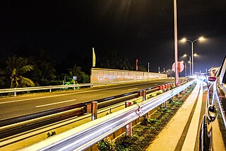
Transport in Sri Lanka is based on its road network, which is centred on the country's capital Colombo. A rail network handles a portion of Sri Lanka's transport needs. There are navigable waterways, harbours and two international airports: in Katunayake, 22 miles (35 km) north of Colombo, and in Hambantota.
The Gulf of Mannar is a large shallow bay forming part of the Laccadive Sea in the Indian Ocean. It lies between the southeastern tip of India and the west coast of Sri Lanka, in the Coromandel Coast region. The chain of low islands and reefs known as Ramsethu, also called Adam's Bridge, which includes Mannar Island, separates the Gulf of Mannar from Palk Bay, which lies to the north between India and Sri Lanka. The estuaries of Thamirabarani River and Vaipar River of South India and the Malvathu Oya of Sri Lanka drain into the Gulf. The dugong is found here.
Point Pedro is a town, located in Jaffna District, Sri Lanka, at the northernmost point of the island.
Islam is a minority religion in Sri Lanka. 9.66% of the Sri Lankan population practice Islam. 1,997,361 persons adhere to Islam as per the census of 2012.
Founded during the British era, Ganemulla is a midsize town situated in the Gampaha District of Sri Lanka. Ganemulla is about 9 km (5.6 mi) from Kadawatha on the Colombo-Kandy road. The nearest city to Ganemulla is Gampaha, which is about 5 kilometres (3.1 mi) away. Ganemulla is surrounded by the towns of Kadawatha, Gampaha, Ja-Ela and Kandana. The population in Ganemulla now exceeds 6,000 and is increasing.The majority of the population are Sinhala Buddhist, with a small Catholic minority.
Deshamanya Marhoom Al Haj Mohammed Abdul Bakeer Markar was a Sri Lankan politician. He was the Speaker of the Parliament of Sri Lanka and Governor of the Southern Province.
The Central Bus Station Bombing was the car bombing of the central bus terminal of Colombo carried out on April 21, 1987 in Pettah, Colombo, Sri Lanka. The bombing killed 113 civilians.
Yachting Association of Sri Lanka (YASL) is recognised by the International Sailing Federation as the governing body for the sport of sailing in Sri Lanka.
The A 2 is an A-Grade road in Sri Lanka. It connects Colombo and Wellawaya via Kalutara, Galle, Matara and Hambantota.
Kinniya is a town located in Trincomalee District of the Eastern province of Sri Lanka. It is located about 20 km (12 mi) from the town of Trincomalee and 240 km (150 mi) from Colombo.
The Sri Lanka Coast Guard is a Sri Lankan non-ministerial government department tasked with coast guard duties within the territorial waters of Sri Lanka. It comes under the purview of the Ministry of Defence and is staffed by civilian personnel. The current Director General of the SLCG is Rear Admiral Samantha Wimalathunga.
Sheikh Mustafa, known as Sheikh Mustafa Waliullah was an Islamic scholar from Sri Lanka. He was also a poet and Sufi. Mustafa was a leader of the Qadiriyyathun Nabaviyyah Sufi order.
The 2014 anti-Muslim riots in Sri Lanka were religious and ethnic riots in June 2014 in south-western Sri Lanka. Muslims and their property were attacked by Sinhalese Buddhists in the towns of Aluthgama, Beruwala and Dharga Town in Kalutara District. At least four people were killed and 80 injured. Hundreds were made homeless following attacks on homes, shops, factories, mosques and a nursery. 10,000 people were displaced by the riots. The riots followed rallies by Bodu Bala Sena (BBS), a hard line Buddhist group. The BBS was widely blamed for inciting the riots but it has denied responsibility. The mainstream media in Sri Lanka censored news about the riots following orders from the Sri Lankan government.
Beruwala electoral district was an electoral district of Sri Lanka between March 1960 and February 1989. The district was named after the town of Beruwala in Kalutara District, Western Province. The 1978 Constitution of Sri Lanka introduced the proportional representation electoral system for electing members of Parliament. The existing 160 mainly single-member electoral districts were replaced with 22 multi-member electoral districts. Beruwala electoral district was replaced by the Kalutara multi-member electoral district at the 1989 general elections.
Imthiaz Bakeer Markar is a Sri Lankan politician. He is the current Chairman of the National Media Centre and former Cabinet Minister of Media, Postal and Telecommunications from 2001 to 2004 and State Minister of Housing from 1989 to 1993. He was also a member of the parliament from the Kalutara District from 1989 to 2004. Bakeer Markar is a former Vice President of the United National Party (UNP).
Ibrahim Adaham Abdul Cader, known as I. A. Cader was a Sri Lankan lawyer and member of the Parliament of Sri Lanka.