U.S. Route 1 or U.S. Highway 1 (US 1) is a major north–south United States Numbered Highway that serves the East Coast of the United States. It runs 2,370 miles (3,810 km) from Key West, Florida, north to Fort Kent, Maine, at the Canadian border, making it the longest north–south road in the United States. US 1 is generally paralleled by Interstate 95 (I-95), though US 1 is significantly farther west and inland between Jacksonville, Florida, and Petersburg, Virginia, while I-95 is closer to the coastline. In contrast, US 1 in Maine is much closer to the coast than I-95, which runs farther inland than US 1. The route connects most of the major cities of the East Coast from the Southeastern United States to New England, including Miami, Jacksonville, Augusta, Raleigh, Richmond, Washington, D.C., Baltimore, Philadelphia, Newark, New York City, New Haven, Providence, Boston, and Portland.

The East Coast Greenway is a 3,000-mile (4,800 km) pedestrian and bicycle route between Maine and Florida along the East Coast of the United States. The nonprofit East Coast Greenway Alliance was created in 1991 with the goal to use the entire route with off-road, shared-use paths; as of 2021, over 1,000 mi (1,600 km) of the route (35%) meets these criteria. In 2020, the Greenway received over 50 million visits.

Interstate 295 (I-295) is a 52-mile-long (84 km) auxiliary Interstate Highway in the US state of Maine from I-95 in Scarborough to I-95 in West Gardiner. The highway was designated the Richard A. Coleman Highway in 2015 by the Maine Legislature. The highway serves as a bypass of Lewiston–Auburn and serves the Portland metropolitan area. It takes a more direct route between Portland and Augusta, the state capital, than its parent I-95. It also is toll-free, unlike I-95, which carries the tolled Maine Turnpike.

The Manhattan Waterfront Greenway is a waterfront greenway for walking or cycling, 32 miles (51 km) long, around the island of Manhattan, in New York City. The largest portions are operated by the New York City Department of Parks and Recreation. It is separated from motor traffic, and many sections also separate pedestrians from cyclists. There are three principal parts — the East, Harlem and Hudson River Greenways.
The Brooklyn–Queens Greenway is a bicycling and pedestrian path connecting parks and roads in the New York City boroughs of Brooklyn and Queens, connecting Coney Island in the south to Fort Totten in the north, on Long Island Sound. The route connects major sites in the two boroughs, such as the New York Aquarium, Brooklyn Museum, the Brooklyn Botanic Garden, the New York Hall of Science, and Citi Field.
U.S. Route 1 (US 1) in the U.S. state of Maine is a major north–south section of the United States Numbered Highway System, serving the eastern part of the state. It parallels the Atlantic Ocean from New Hampshire north through Portland, Brunswick, and Belfast to Calais, and then the St. Croix River and the rest of the Canada–United States border via Houlton to Fort Kent. The portion along the ocean, known as the Coastal Route, provides a scenic alternate to Interstate 95 (I-95).

Yarmouth is a town in Cumberland County, Maine, United States, twelve miles north of the state's largest city, Portland. When originally settled in 1636, as North Yarmouth, it was part of the Massachusetts Bay Colony, and remained part of its subsequent incarnations for 213 years. In 1849, twenty-nine years after Maine's admittance to the Union as the twenty-third state, it was incorporated as the Town of Yarmouth.

Burke Brook is a small stream in Toronto, Ontario. It is part of the Don River watershield, a major river that flows into Lake Ontario. The north end of the stream begins near Glenview Senior Public School.
The historical buildings and structures of Yarmouth, Maine, represent a variety of building styles and usages, largely based on its past as home to almost sixty mills over a period of roughly 250 years. These mills include that of grain, lumber, pulp and cotton. Additionally, almost three hundred vessels were launched by Yarmouth's shipyards in the century between 1790 and 1890, and the homes of master shipwrights and ship captains can still be found throughout the town.

Minneapolis is often considered one of the top biking and walking cities in the United States due to its vast network of trails and dedicated pedestrian areas. In 2020, Walk Score rated Minneapolis as 13th highest among cities over 200,000 people. Some bicycling ratings list Minneapolis at the top of all United States cities, while others list Minneapolis in the top ten. There are over 80 miles (130 km) of paved, protected pathways in Minneapolis for use as transportation and recreation. The city's Grand Rounds National Scenic Byway parkway system accounts for the vast majority of the city's shared-use paths at approximately 50 miles (80 km) of dedicated biking and walking areas. By 2008, other city, county, and park board areas accounted for approximately 30 miles (48 km) of additional trails, for a city-wide total of approximately 80 miles (130 km) of protected pathways. The network of shared biking and walking paths continued to grow into the late 2010s with the additions of the Hiawatha LRT Trail gap remediation, Min Hi Line pilot projects, and Samatar Crossing. The city also features several natural-surface hiking trails, mountain-biking paths, groomed cross-country ski trails in winter, and other pedestrian walkways.

Royal River Park is an urban park in Yarmouth, Maine, United States. It is located to the northwest of the town center, between East Elm Street to the west and Bridge Street to the east. U.S. Route 1 runs through the park via an overpass.

Cycling infrastructure in the Canadian city of Halifax, Nova Scotia includes most regular streets and roads, bike lanes, protected cycle tracks, local street bikeways, and multi-use pathways.

Carl Henry Winslow was an American fire chief and United States Army Reserves staff sergeant. He was the fire chief in Yarmouth, Maine, for seventeen years. The town's former fire station is now named for him.
Elm Street is a prominent street in Yarmouth, Maine, United States. It runs for about 2.7 miles (4.3 km) from North Road in the north to Portland Street in the south. The street's addresses are split between "West Elm Street" and "East Elm Street", the transition occurring at Main Street in the Upper Village. Several of its buildings are homes dating to the late 18th and early 19th centuries.

Portland Street is a historic street in Yarmouth, Maine, United States. It runs for about 1.25 miles (2.01 km) from the town's Main Street, State Route 115, in the north to its merge with Middle Road in the south. It is so named because it leads to Portland, the state's largest city, after linking up with State Route 9 in Falmouth, Maine.

Princes Point Road is a prominent street in Yarmouth, Maine, United States. It runs for about 1.93 miles (3.11 km) from Lafayette Street in the north to Sunset Point Road in the south. It was one of the first streets laid out in the town when it was centered around the Meetinghouse under the Ledge in the 18th century. Gilman Road, another of the early roads in the area, intersects Princes Point Road near its northern end.
Martin's Point Bridge spans the Presumpscot River in Maine, United States, near the river’s mouth with Casco Bay. It connects Falmouth Foreside, at Mackworth Point, in the north, to the East Deering neighborhood of Portland, at Martin's Point, in the south. 1,300 feet (400 m) in length, it carries vehicular and pedestrian traffic of U.S. Route 1. The bridge is two lanes, including a bicycle lane in each, with a pedestrian lane on the eastern side. A similar plan for the western side of the bridge was abandoned.

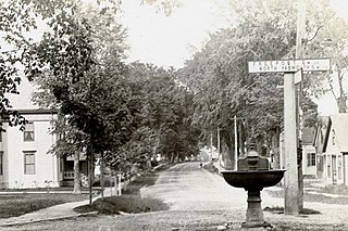
Portland and Yarmouth Electric Railway was an electric trolleycar service that ran along the coast between Portland and Yarmouth, Maine, from 1898 and 1933. Described in 1901 as the "new electric road", Yarmouth was "now a closer neighbor [to Portland] than ever before" because of the railway's advent.

The Metro Breez is an express bus service in Southern Maine, United States, provided by Greater Portland Metro. It runs thirteen times on weekdays and six times on Saturdays between Portland, the state's largest city, and Brunswick, around 30 miles (48 km) to the northeast, with stops in Yarmouth and Freeport.

Brickyard Hollow is the central section of Main Street in Yarmouth, Maine, located between the Upper Village to the northwest and Lower Falls to the southeast. It is named for the brick-making business that was located across the street from the Masonic Hall at 189 Main Street, beneath the U.S. Route 1 overpass, which was built in the 1870s.