Related Research Articles

The Regional Municipality of York, also called York Region, is a regional municipality in Southern Ontario, Canada, between Lake Simcoe and Toronto. The region was established after the passing of then Bill 102, An Act to Establish The Regional Municipality of York, in 1970. It replaced the former York County in 1971, and is part of the Greater Toronto Area and the inner ring of the Golden Horseshoe. The regional government is headquartered in Newmarket.

Whitchurch-Stouffville is a town in the Greater Toronto Area of Ontario, Canada, approximately 50 km (31 mi) north of downtown Toronto, and 55 km (34 mi) north-east of Toronto Pearson International Airport. It is 206.22 km2 (79.62 sq mi) in area, and located in the mid-eastern area of the Regional Municipality of York on the ecologically-sensitive Oak Ridges Moraine. Its motto since 1993 is "country close to the city".
Stouffville is the primary urban area within the town of Whitchurch-Stouffville in York Region, Ontario, Canada. It is situated within the Greater Toronto Area and the inner ring of the Golden Horseshoe. The urban area is centred at the intersection of Main Street, Mill Street, and Market Street. Between 2006 and 2011, the population of the Community of Stouffville grew 100.5% from 12,411 to 24,886, or from 51% to 66% of the total population of the larger town of Whitchurch-Stouffville.

Musselman's Lake is a community settled adjacent to a 118-acre (0.48 km2) kettle lake of the same name in the town of Whitchurch–Stouffville, Ontario, Canada. It is located about 6 km north-northwest of urban Stouffville, and is part of the Greater Toronto Area.

Stouffville GO Station is a railway station in the GO Transit network located in Stouffville, Ontario, Canada. It was the northern terminus of the Stouffville line train service until the line was extended to Lincolnville on September 2, 2008. Buses serve the station from stops on the street due to space limitations.

The history of Markham, Ontario dates back several millennia. What would become Markham, Ontario was home to First Nations long before European settlement. Seasonal settlements were found from 900 BC to 1650, but traces of these first residence were buried before the area was farmed.
Ballantrae, Ontario is a hamlet in the Town of Whitchurch–Stouffville. Named after the village of Ballantrae in South Ayrshire, Scotland, the community is centred on the intersection of Aurora Road and Highway 48.
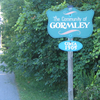
Gormley is a hamlet in York Region, Ontario, Canada that overlaps parts of Richmond Hill, and Whitchurch–Stouffville, two municipalities within the Greater Toronto Area. It was divided into two parts due to the construction of Highway 404. A portion of Gormley situated within Richmond Hill's political boundaries is subject to "Heritage Conservation District" controls. A post office in Gormley (East) serves as the mailing address for the Whitchurch–Stouffville communities of Bethesda, Gormley, Preston Lake, Vandorf, and Wesley Corners.
Dickson Hill is a small community in northeast Markham, Ontario, Canada, located near Highway 48 and 19th Avenue, on the border to Whitchurch-Stouffville.
Vandorf is a hamlet located in the town of Whitchurch–Stouffville, Ontario, in Canada. It is the most westerly settlement within the Town of Whitchurch-Stouffville. With a population of approximately 722, Vandorf consists mainly of estate residential homes and farms.

Old Elm GO Station is a train and bus station in the GO Transit network located in Whitchurch-Stouffville, Ontario, Canada. Old Elm is the northeastern terminus of train service on the Stouffville line. The station opened on September 2, 2008, after some delay; it had initially been projected to open the preceding June.

Altona is a ghost town located in Pickering, Ontario, at Sideline 30 and the Pickering-Uxbridge Town Line. It is just east of Whitchurch-Stouffville, and was named after Altona, now a borough of Hamburg, Germany.
Pleasantville is a community located in the Town of Whitchurch–Stouffville, Ontario, Canada.
Preston Lake is a community located in the town of Whitchurch–Stouffville in the Regional Municipality of York in Ontario, Canada. The community is centred on Preston Lake, a natural glacier kettle lake, immediately north-east of the intersection of Bloomington Road and Woodbine Avenue, east of Highway 404, near Aurora.
Wesley Corners is a community situated in the Town of Whitchurch–Stouffville, Ontario, Canada.

Ringwood is a hamlet in York Region, Ontario, Canada, in the Town of Whitchurch–Stouffville. The hamlet is centred at the intersection of Stouffville Road and Highway 48, on the Little Rouge River, a tributary of the Rouge River on the Oak Ridges Moraine. The community originally straddled the townships of Markham and Whitchurch in the County of York. The hamlet was named Ringwood in 1856 by George Sylvester, postmaster and owner of a general store, after the town of Ringwood, in Hampshire, England. It was first settled in the 1790s by George Fockler from Pennsylvania. The Little Rouge River runs along the eastern edge of the hamlet. In 1857, Ringwood had a population of 200 which grew only slightly to 225 by 1910. By 1972, the population had dropped to 172. Between 2008 and 2010, more than 250 homes were constructed in Ringwood's Cardinal Point subdivision north of Main Street. Construction on a new auto mall in Ringwood began in 2009, with Hyundai and Toyota dealerships opening in 2010, and Dodge/Jeep and Nissan dealerships constructed in 2013.
Bloomington is a hamlet in York Region, Ontario, Canada, in the town of Whitchurch-Stouffville. The hamlet is centred at the intersection of Ninth Line and Bloomington Road near the eastern boundary of the town of Whitchurch–Stouffville. Neighbouring communities within Whitchurch–Stouffville include Musselman Lake to the north, Lemonville to the west, and the community of urban Stouffville to the south. The hamlet of Goodwood in the town of Uxbridge lies to the east.

Lemonville is a hamlet in York Region, Ontario, Canada, in the town of Whitchurch–Stouffville. The hamlet is centred at the intersection of McCowan Road and Bloomington Road, in the geographical centre of Whitchurch-Stouffville.
Pine Orchard is a hamlet in York Region, Ontario, Canada, in the town of Whitchurch–Stouffville. It is centred at the intersection of Warden Avenue and Vivian Road in the north-western region of Whitchurch–Stouffville. The original settlers were Quakers who, like the early Mennonites of Whitchurch and Markham townships, were pacifists that came north after the American Revolution. The founder of the hamlet was Isaac Phillips, who arrived from Muncy County, Pennsylvania in 1802. A first post-office was established in 1853, and by 1860 three sawmills were operating in the area. In 1858 the hamlet had a population of 35. The community flourished towards the end of the nineteenth century until township; however at the beginning of the twentieth century the township was almost completely deforested, and the forest industry collapsed. The hamlet's post-office closed in 1914.

Abraham Stouffer is the founder of the town of Stouffville, Ontario.
References
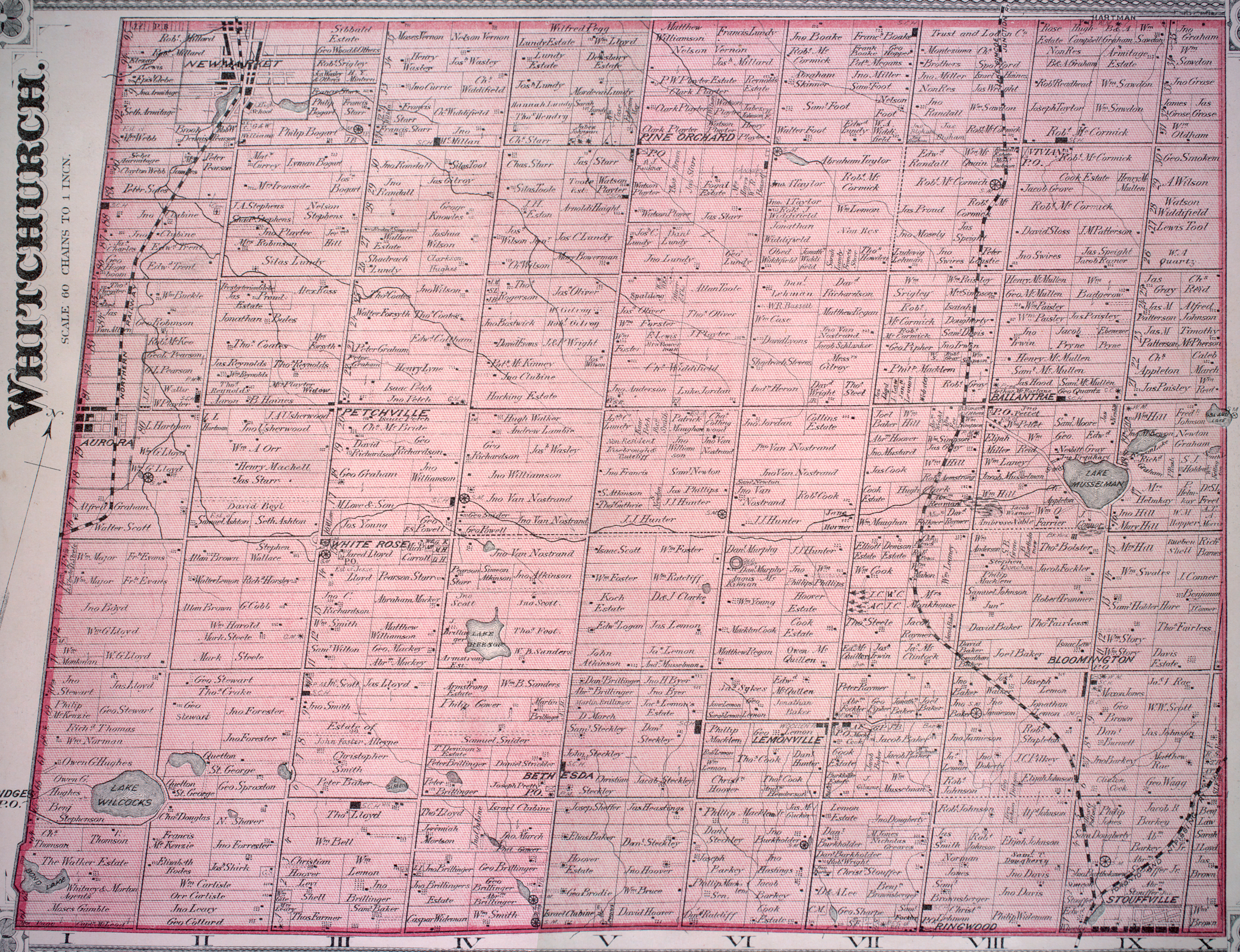
- ↑ See the detailed 1878 map: Township of Whitchurch, Illustrated historical atlas of the county of York and the township of West Gwillimbury & town of Bradford in the county of Simcoe, Ont. (Toronto: Miles & Co., 1878).
- ↑ Fretz, J. C. (1953). "Bethesda (York County, Ontario, Canada)". Global Anabaptist Mennonite Encyclopedia Online. Retrieved March 24, 2023.
- ↑ For a brief account of Bethesda's history, cf. Jean Barkey et al., Whitchurch Township (Erin, ON: Boston Mills, 1993), 72-74.
| | This Ontario geographical article about a location in the Golden Horseshoe is a stub. You can help Wikipedia by expanding it. |