
Ilama is a municipality in the Honduran department of Santa Bárbara.
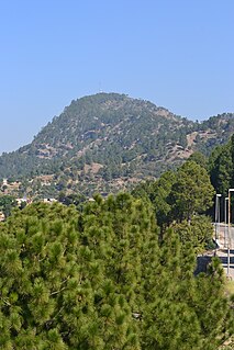
Serian is a town in the Khyber Pakhtunkhwa province of Pakistan, it is located at 34°23'60N 72°58'60E. Around 15 minutes of drive from the Shah Maqsood, its surrounded by beautiful mountains around.

Mojmírovce is a village and municipality in the Nitra District in western central Slovakia, in the Nitra Region.
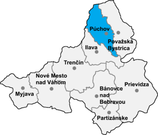
Kvašov is a village and municipality in Púchov District in the Trenčín Region of north-western Slovakia.
Los Balbases is a municipality located in the province of Burgos, Castile and León, Spain. According to the 2004 census (INE), the municipality has a population of 348 inhabitants.
Boken or Bokan is a village in Union Council Raman of Gujar Khan Tehsil in the Punjab Province of Pakistan and is located at 33°9′N73°4′E with an altitude of 489 metres (1,604 ft).
Guitanga is a village in the Bogandé Department of Gnagna Province in eastern Burkina Faso. The village has a population of 755.
Madori is a town in the Manni Department of Gnagna Province in eastern Burkina Faso. The town has a population of 1,577.
Mohra Darogha is a village in Rawat, Rawalpindi, Pakistan.
Nutu is a village in Kose Parish, Harju County in northern Estonia.
Hundsburg is a hill in the county of Schwalm-Eder-Kreis, Hesse, Germany.
The Mbe Mountains Community Forest is situated in southern Nigeria, and covers 86 km².
Saiakopli is a village in Tapa Parish, Lääne-Viru County, in northeastern Estonia. It's located about 7.5 km (5 mi) southeast of the town of Tapa and about 7 km (4 mi) northwest of Tamsalu. Saiakopli is bordered by the Tallinn–Tapa–Tartu railway to the southwest and by the Valgejõgi River to the northwest.

Bensekrane is a town and commune in Tlemcen Province in northwestern Algeria.
Lohi Bher is a populated place in Islamabad, Pakistan. neighborhood's within Union Council Lohi bher are bahria town, PWD, Police foundation town, CBR town, media town, korang town, Pakistan town
Islamabad is located at 33.43°N 73.04°E at the edge of the Pothohar Plateau at the foot of the Margalla Hills in Islamabad Capital Territory. Its elevation is 507 metres (1,663 ft). The modern capital and the ancient Gakhar city of Rawalpindi stand side by side and are commonly referred to as the Twin Cities. To the east of the city lies Murree and Kotli Sattian. To the north lies the Haripur District of Khyber Pakhtunkhwa. Kahuta lies on the northeast, Taxila, Wah Cantt, and Attock District to the northwest, Gujar Khan, Kallar Syedan, Rawat, and Mandrah on the northeast, and Rawalpindi to the southwest. Islamabad is located 120 kilometres (75 mi) SSW of Muzaffarabad, 185 kilometres (115 mi) east of Peshawar, 295 kilometres (183 mi) NNE of Lahore, and 300 kilometres (190 mi) WSW of Srinagar, the capital of Indian Kashmir.
Türkmenakören is a village in the District of Emirdağ, Afyonkarahisar Province, Turkey.
Civil Lines is a Civil Lines residential area built by the British Raj in Faisalabad, Punjab. It was built for the civil officers.
Holovkivka is a village in Oleksandriia Raion, Kirovohrad Oblast, Ukraine. The village has a population of 2,217.


