
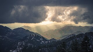
Nathia Gali or Nathiagali is a hill station and mountain resort town located in the Abbottabad District of Khyber Pakhtunkhwa, Pakistan. It is located at the centre of the Galyat range, where several hill stations are situated. Nathia Gali is known for its scenery, hiking trails and weather, which is much cooler than the rest of the Galyat range due to it being at a higher altitude. It is situated approximately 32 kilometres (20 mi) away from both Murree and Abbottabad.
Galyat region, or hill tract, is a narrow strip or area roughly 50–80 km north-east of Islamabad, Pakistan, extending on both sides of the Khyber Pakhtunkhwa-Punjab border, between Abbottabad and Murree. The word itself is derived from the plural of the Urdu word gali, which means an alley between two mountains on both sides of which there are valleys and it is not the highest point in the range. Many of the towns in the area have the word gali as part of their names, and are popular tourist resorts. Being on linguistic and geographical continuum this area has challenged social scientists in terms of anomalous classification.

Murree is a mountain resort city, located in the Galyat region of the Pir Panjal Range, within the Murree District of Punjab, Pakistan. It forms the outskirts of the Islamabad-Rawalpindi metropolitan area, and is about 30 km (19 mi) northeast of Islamabad. It has average altitude of 2,291 metres (7,516 ft). The British built this town during their rule to escape the scorching heat in the plains of Punjab during the summer.
Murree Brewery ; PSX: MUREB) is a Pakistani multinational manufacturer of alcoholic and non-alcoholic beverages. It is Pakistan's largest and oldest producer of alcoholic products. In 2015, it produced 10 million litres of beer, along with hundreds of tons of single malt whisky, vodka and brandy. Founded by the British in 1860, it is a publicly traded company listed on the Pakistan Stock Exchange, and its products are exported to India and Bangladesh. In 2014, the company established a flagship store on Park Avenue, in Manhattan, New York City. In 2013, it was named by Forbes as one of Asia's 200 best companies.

Bhurban is a small town and a hill station in Muree District, West Punjab on the edge of Hazara, Pakistan. The resort town is named after a nearby forest. It is located approximately 11 kilometres (6.8 mi) from Murree city.

Ayubia National Park, also known as Ayubia, is a protected area of 3,312 hectares (33 km2) located in Abbottabad District, Khyber Pakhtunkhwa province, Pakistan. It was declared a national park in 1984. Ayubia was named after Muhammad Ayub Khan (1958–1969), second President of Pakistan. The area supports temperate coniferous forest and temperate broadleaf and mixed forest ecoregion habitats, with an average elevation of 8,000 feet (2,400 m) above sea level. Ayubia National Park is surrounded by seven major villages and three small towns of Thandiani, Nathiagali and Khanspur. The park has been developed as a resort complex from a combination of four mini resorts of Khaira Gali, Changla Gali, Khanspur and Ghora Dhaka in Galyat. Currently, it is managed by the Wildlife and Parks Department of Government of Khyber Pakhtunkhwa.

Lawrence College Ghora Gali is a school situated in Murree Tehsil, Punjab, Pakistan. The college is located in the foothills of the Himalayas and Pir Panjal at a height of about 1950 metres above sea level, covering an area of 150 acres (61 ha). It is 4 km from Murree and 57 km from Rawalpindi/Islamabad.
The Murree Rebellion of 1857 was a part of the Indian Rebellion of 1857. It was a skirmish between the hill tribes of Murree and the colonial government of British India. Resentment toward colonial rule had been mounting for many years following the establishment of British Raj in the subcontinent. There had been occasional isolated uprisings toward the British. The significance of the 1857 events was that, although not centrally coordinated, the uprisings had the feel of something much larger with real anticipation that colonial rule would be overthrown.

Goreeni is one of the 51 union councils of Abbottabad District in Khyber-Pakhtunkhwa province of Pakistan.

Dunga Gali is one of the towns of the Galyat area of Ayubia National Park, at an altitude of 2,500 metres (8,200 ft) in northern Pakistan. Dunga Gali is located in Nathia Gali Union Council (subdivision) of Abbottabad District in the Khyber Pakhtunkhwa Province. It is 3 kilometres (1.9 mi) from Nathia Gali.
Khaira Gali is one of the tourist mountain resort towns of the Galyat area of Pakistan, it has an altitude of 2347m. Khaira Gali is located in Palak which is a Union Council of Abbottabad District in Abbottabad province of Pakistan. This hill station was also used as a barricade by the British during the colonial period and during the summer months it was occupied by one of the British mountain batteries, which were stationed at Rawalpindi during the winter. It is also famous for the hexagon manor on the highest elevation of the town.
This is about a mountain resort town in Pakistan. For the Capital of Bangladesh, see Dhaka
Darya Gali is a village and union council of Murree Tehsil in the Murree District of Punjab, Pakistan. It is located in the north of the tehsil and is bounded to the north by Khyber-Pakhtunkhwa, to the south by Ghora Gali and Murree, and to the west by Rawat.

Abbottabad Tehsil is an administrative subdivision (tehsil) of Abbottabad District in the Khyber Pakhtunkhwa province of Pakistan.
Barian is a town in Punjab (Pakistan). It is located at 33°57'0N 73°23'0E. The town is linked to the city of Abbottabad by a 71 km road via Nathia Gali, the area is often cut off during bad winter weather, in 2005 heavy snowfall had cut the roads to Khanspur and Changla Gali, and in January 2008 snow and heavy landslides cut off roads.
Tret is a village and union council of Murree Tehsil in the Murree District of Punjab, Pakistan. It is located in the south of the tehsil at 33°49′60″N 73°16′60″E and is bounded to the north by Khyber Pakhtunkhwa, to the north-east by Ghora Gali, to the east by Numbal and to the south by Angoori. During the British rule, Tret housed a few army installations and a Dak Bungalow
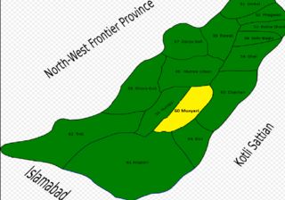
Musyari (Punjabi, Urdu: مسیاڑی is a village and union council of Murree Tehsil in the Murree District of Punjab, Pakistan.
Charihan is a village and union council of Murree Tehsil in the Murree District of Punjab, Pakistan. It is located in the east of the tehsil at 33°49'0N 73°28'0E and is bounded to the north by Mussiari, to the north by Ghel, to the north-west by Murree city, to the west by Mussiari, to the south by Ban and to the south and east by Kotli Sattian.

Usman Ali Isani is a former senior Pakistani bureaucrat, educationist and a philatelist.
The Lawrence Military Asylums were a series of military-style boarding schools envisaged by Sir Henry Lawrence in the Indian subcontinent highlands for the sons and daughters of British soldiers. Two schools were established during Lawrence's lifetime, at Sanawar and Mount Abu, a third followed a year after his death at Lovedale, whilst a fourth was later built in his memory at Ghora Gali.
