This article needs additional citations for verification .(May 2012) |
Mohra Rajgan is a village in Bhalakhar, Kallar Syedan tehsil, Rawalpindi District, Pakistan. [1] The population of Mohra Rajgan peoples belong to Gakhar tribe.
This article needs additional citations for verification .(May 2012) |
Mohra Rajgan is a village in Bhalakhar, Kallar Syedan tehsil, Rawalpindi District, Pakistan. [1] The population of Mohra Rajgan peoples belong to Gakhar tribe.

The Arctic Archipelago, also known as the Canadian Arctic Archipelago, is an archipelago lying to the north of the Canadian continental mainland, excluding Greenland and Iceland.
Mohra Sharif is a small village located in the Murree Hills of Punjab, near the Pakistani capital of Islamabad. It is well known as a spiritual center for Sufism. It is also known as "Darbar Alia Mohra Sharif."

Pirates Cove Marine Provincial Park is a provincial park on De Courcy Island in British Columbia, Canada.
Dhoke Budhal is a village in Rawalpindi District, of Punjab, Pakistan.
Narali is one of the oldest and largest towns of Gujar Khan Tehsil, Punjab province of Pakistan. Narali used to be the hub of trade before partition. It had large Hindu and Sikh populations that dominated the trade circle. It still has a number of remains and ruins of Hindu culture and temples. It is culturally richer than the adjoining villages. Narali enjoys a very important position because it has union council office, patwarkhana, health centre and a post office.
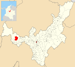
San Pablo de Borbur is a town and municipality in the Colombian Department of Boyacá, part of the subregion of the Western Boyacá Province. The three most important productive sectors are agriculture, livestock and mining, with the emerald being one of the representative elements of the region.
Kauntrila (Urdu:کونتريله) is the name of a village and union council of Gujar Khan Tehsil in Rawalpindi District, Punjab, Pakistan. Kauntrila is a populated small town among few of old qasbas in Tehsil Gujar Khan. It is also an active union council of Gujar Khan Tehsil.
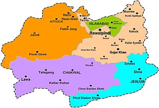
Kallar Syedan is a tehsil in the Rawalpindi District, Punjab, Pakistan. Earlier a part of the Kahuta Tehsil, it became a separate tehsil on 1 July 2004.
Bhata is a village in Pakistan which is located in the centre of Mandra-Chowk Pindori Road, Tehsil Gujar Khan, Rawalpindi District.
Thakra is a village in the Gujar Khan Tehsil of Rawalpindi District in the Punjab province of Pakistan. It links Rawalpindi, Chakwal and Jhelum. Thakra is located at an altitude of 173 metres (568 ft).
Gujaran Na Mohra is a union council in the Islamabad Capital Territory of Pakistan. It is located at 33°26'46" N 73°24'55" E, with an altitude of 572 metres.

.
Sarai Alamgir Tehsil is one of four administrative subdivision areas, or Tehsils, in the District of Gujrat. The Tehsil is located on the eastern bank of the Jhelum River across from the larger town of Jhelum. East of the Tehsil is the Upper Jhelum Canal.
Pakhrals also known as Minhas and Jamwal in different regions were founders of the city and the state of Jammu and its governors from ancient times. Their ancestors were rajput warrior clans who later accepted Islam after the Muslim influence in Indian Region and moved from Rajasthan (India) to Kashmir and Pakistan. Pakhral Rajputs are known to be warriors, hospitable and aggressive people. Pakhrals reside mainly in Pothowar including Rawalpindi, Islamabad, Upper Salt Range region, while some tribes are in Azad Jammu Kashmir, Indian Occupied Kashmir, Punjab, Hazara and Dera Ismail Khan. Potohar area is famous as Pakhral Rajputs area. Raja is mostly used as a title in Pakhral Rajputs which is derived from the word Rajput. Many Pakhral Rajputs were included in the so called khana number 10 during the British rule in India. Since partition Pakhrals have been involved in different enterprises, while many adopted government careers, law, politics, anthropology, education etc. and a good chunk are in foreign countries.
Iyal Surayh District is a district of the 'Amran Governorate, Yemen. As of 2003, the district had a population of 54,015 inhabitants.
Mohra Sandhu is a village situated in the Gujar Khan Tehsil of Rawalpindi District, of Punjab, Pakistan. Its geographical coordinates are 33° 21' 37 North and 73° 25' 40 East and situated in Sui Cheemian Union Council.

German submarine U-991 was a Type VIIC U-boat of Nazi Germany's Kriegsmarine during World War II.
Semyonovka is the name of several rural localities in Russia.
The Anglican Diocese of Idah is one of 11 within the Anglican Province of Lokoja, one of the 14 provinces within the Church of Nigeria. The current bishop is Joseph Musa. The Rt Revd Joseph Musa was consecrated on 13 March, 2005 as the new Bishop of Idah. Idah dioceses are among the 17 dioceses of the Abuja Province, which was created on 14 March 2005.
32°45′N73°05′E / 32.750°N 73.083°E
| | This article about a location in Rawalpindi District, Punjab (Pakistan) is a stub. You can help Wikipedia by expanding it. |
