Sumbal Bia | |
|---|---|
Village | |
| Country | |
| Province | Punjab |
| District | Rawalpindi |
| Tehsil | Murree |
| Population | |
| • Total | 2,000 |
Sumbal Bia is a town of Mussiari, Murree Tehsil in the Rawalpindi District of Punjab, Pakistan. [1]
Sumbal Bia | |
|---|---|
Village | |
| Country | |
| Province | Punjab |
| District | Rawalpindi |
| Tehsil | Murree |
| Population | |
| • Total | 2,000 |
Sumbal Bia is a town of Mussiari, Murree Tehsil in the Rawalpindi District of Punjab, Pakistan. [1]
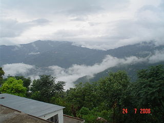
It is located in the southwest of the Tehsil and is bounded to the north by Jhika Gali, to the south by Angoori, Murree, to the west by Numbal and to the east by Murree Expressway - N75.
It had a population of 2,000 in 2008. [2]
The majority of people work in the government service sector. The rest of them run businesses such as shopkeeping, general stores, tattoo artists and poultry farming. In the past people cultivated crops on their land, but due to unavailability of resources this occupation is left out. The common professions and occupations are:
There are three primary schools
The majority of the inhabitants of Sumbal Bia are the Abbasi. Other tribes such as the Malik Awan, Qureshi, Mughal and Rajput (Khakha) inhabit the area in smaller proportions.
Sumbal Bia is home to predominantly poor inhabitants. The area has not been economically prosperous due to lack of infrastructure such as regular water supply, safe roads and higher education establishments. Basic services that are available include:
There are three mosques in Sumbal Bia:

Murree is a mountain resort town, located in the Galyat region of the Pir Panjal Range, within the Rawalpindi District of Punjab, Pakistan. It forms the outskirts of the Islamabad-Rawalpindi metropolitan area, and is about 30 km (19 mi) northeast of Islamabad. It has average altitude of 2,291 metres (7,516 ft). The British built this town during their rule to escape the scorching heat in the plains of Punjab during the summer.

Dewal also known as Dewal Sharif is a Union council of Murree Tehsil, of Rawalpindi District in the Punjab province of Pakistan.
Malkot is a village of Abbottabad District in Khyber-Pakhtunkhwa province of Pakistan. Until the local government reforms of 2000 it was a Union Councils of the district.

Kotli Sattian is a tehsil (subdivision) of Rawalpindi District in the Punjab province of Pakistan. Its name is derived from the mountain town of Kotli and the Satti tribe. This subdivision is geographically a part of the Murree and Kahuta hills. It was declared a subdivision in 1990 by breaking up 40 villages out of both subdivisions. The people of Kotli Sattian are referred to as Pahari people. The language of this region and of the neighbouring areas of Azad Jammu and Kashmir and some areas of east Khyber Pakhtunkhwa is Pahari.
Ghora Gali is one of the tourist mountain resort towns of the Galyat area of northern Pakistan. It has an elevation of 1691m and is located in the northeastern tip of the Punjab province of Pakistan. Ghora Gali is also a Union council, an administrative subdivision, of Murree Tehsil in Rawalpindi District and is located at 33.83°N 73.35°E. According to the 1998 census of Pakistan it had a population of 14410.
Murree Tehsil is one of the seven Tehsils of Rawalpindi District in the Punjab province of Pakistan.

Phagwari is a village and union council of Murree Tehsil in the Rawalpindi District of Punjab, Pakistan. It is located at 33°58'60N 73°30'0E in the north-west of the tehsil, it is bounded to the north by Dewal, to the west by Rawat, to the south by Potha Sharif and to the east by Kashmir. According to the 1998 census of Pakistan it had a population of 13,060.
Darya Gali is a village and union council of Murree Tehsil in the Rawalpindi District of Punjab, Pakistan. It is located in the north of the tehsil and is bounded to the north by Khyber-Pakhtunkhwa, to the south by Ghora Gali and Murree, and to the west by Rawat.
Angoori is a village and union council of Murree Tehsil in the Rawalpindi District of Punjab, Pakistan. It is located in the south of the tehsil and is bounded to the north-west by Tret, to the north by Numbal and Mussiari, to the north-east by Ban and to the south by the Islamabad Capital Territory. The area is known for its peaceful environment, adaptive and pleasant weather with an eye catching view of the twin cities.
Ban is a village and union council of Murree Tehsil in the Rawalpindi District of Punjab, Pakistan. It is located in the south of the tehsil, and is bounded to the north by Mussiari, to the north-east by Charhan, to the east by Angoori and to the south by Kotli Sattian.
Ghel is a village and union council of Murree Tehsil in the Rawalpindi District of Punjab, Pakistan.
Tret is a village and union council of Murree Tehsil in the Rawalpindi District of Punjab, Pakistan. It is located in the south of the tehsil at 33°49′60″N 73°16′60″E and is bounded to the north by Khyber Pakhtunkhwa, to the north-east by Ghora Gali, to the east by Numbal and to the south by Angoori. During the British rule, Tret housed a few army installations and a Dak Bungalow
Sehr Bagla is a Village and Union Council of Murree Tehsil in the Rawalpindi District of Punjab, Pakistan. It is located in the north-east of the Tehsil and is bounded to the north by Potha Sharif, to the south by Ghel, to the west by Rawat and to the east by Kashmir
Potha Sharif is a village and union council of Murree Tehsil in the Rawalpindi District of Punjab, Pakistan. It is located in the north-east of the tehsil at 33°57'0N 73°30'0E, and is bounded to the north by Phagwari, to the south by Sehr Bagla, to the west by Rawat and to the east by Kashmir. The Potha hill has great and attractive view. The upper part of UC known as DANNA has exclusive land price and many outcasts from cities buy plots and built homes to enjoy the summer season. The village contains the mazar of the Sufi saint Hazarat Dada Malik Suraj Abbasi forefather of Potha Shareef peoples. He had seven sons and their descendants are currently present in Potha Shareef. People visit the mazar from different areas of the country to offer tribute.
Numbal is a village and union council of Murree Tehsil in the Rawalpindi District of Punjab, Pakistan.
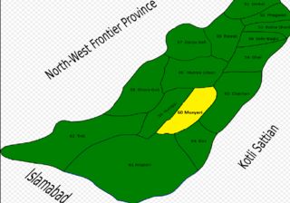
Musyari (Punjabi, Urdu: مسیاڑی is a village and union council of Murree Tehsil in the Rawalpindi District of Punjab, Pakistan.
Renala Khurd is an administrative subdivision (tehsil) of Okara District in the Punjab province of Pakistan. It is administratively subdivided into 18 Union Councils, two of which form the tehsil capital Renala Khurd.

Ausia is a village in the Union council of Dewal, Murree Tehsil (مری), Rawalpindi District, Pakistan. It borders Union Councils of Rawat, Phagwari & Malkot. It is located on Upper Kohala Road at 33°59'0N .73°28'0E at an altitude of 1712 meters (5620). Ausia's boundary starts from spotting Murree-Meridian Marriage Hall, from where the road starts its descent down towards the core village and spreads up to 'Peida' near ex-PM of Pakistan Shahid Khaqan Abbasi's residence & here the next model village 'Dewal' situated in the same UC initiates.
Charihan is a village and union council of Murree Tehsil in the Rawalpindi District of Punjab, Pakistan. It is located in the east of the tehsil at 33°49'0N 73°28'0E and is bounded to the north by Mussiari, to the north by Ghel, to the north-west by Murree city, to the west by Mussiari, to the south by Ban and to the south and east by Kotli Sattian.
Phaphril is a village of Union Council Mussiari Murree Tehsil in the Rawalpindi District of Punjab, Pakistan.
