Rawalpindi is the third-largest city in the Pakistani province of Punjab. It is a commercial and metropolitan city being the fourth most populous in Pakistan. It is located near the Soan River in north-western Punjab, and is the third-largest Punjabi-speaking city in the world. Rawalpindi is situated close to Pakistan's capital Islamabad, and the two are jointly known as the "twin cities" because of the social and economic links between them.

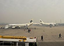
Benazir Bhutto International Airport is an airport which formerly served the Islamabad-Rawalpindi metropolitan area. It was the second-largest airport by air traffic in Pakistan, until 12 May 2021 when it was replaced by the new Islamabad International Airport. Also known as Chaklala Airbase, it was renamed after the late Pakistani prime minister Benazir Bhutto (1953–2007) in June 2008. The airport handled 4,767,860 passengers in 2015–16, compared to 3,610,566 in 2010–11.

Murree is a mountain resort city, located in the Galyat region of the Pir Panjal Range, within the Murree District of Punjab, Pakistan. It forms the outskirts of the Islamabad-Rawalpindi metropolitan area, and is about 30 km (19 mi) northeast of Islamabad. It has average altitude of 2,291 metres (7,516 ft). The British built this town during their rule to escape the scorching heat in the plains of Punjab during the summer.

Risalpur is a city in Nowshera District, Khyber-Pakhtunkhwa, Pakistan, on the Nowshera-Mardan Road. It is nearly 45 km from Peshawar and 18 km from Mardan and is located at 34°4'52N 71°58'21E. In a basin some 1014 feet above sea level, it is bounded on the south and west by the Kabul and Kalpani rivers, respectively. The famous Khyber Pass lies 90 kilometers to the north.

Pakistan Air Force Base, Nur Khan is an active Pakistan Air Force airbase located in Chaklala, Rawalpindi, Punjab province, Pakistan. The former Benazir Bhutto International Airport forms part of this airbase. Fazaia Intermediate College, Nur Khan is also located in the base.

Rawalpindi is a tehsil - an administrative subdivision - of Rawalpindi District in the western part of the Punjab province, Pakistan, it contains the district capital - the city of Rawalpindi.

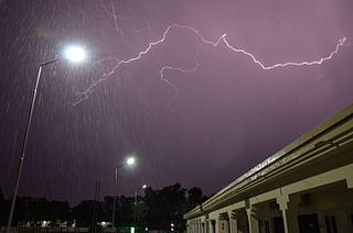
The Pakistan Meteorological Department (PMD) (Urdu: محکمہ موسمیات پاکستان, also known as Pakistan Met Office), is an autonomous and independent institution tasked with providing weather forecasts and public warnings concerning weather for protection, safety and general information.

Islamabad International Airport is the international airport serving Islamabad, the capital city of Pakistan and Rawalpindi. It is located 25 km (16 mi) south-west of the city, and is accessed via Srinagar Highway.
Lalkurti, is a locality in the heart of Rawalpindi cantonment in Pakistan. Places with the same name are also found in many other garrison cities of Pakistan and India, such as Peshawar, Lahore, Kanpur, Ambala, Meerut and Delhi.
Saddar, Rawalpindi, Pakistan, is the main commercial hub of Rawalpindi Cantonment. It is located between the Mall road and the main railway lines connecting Rawalpindi with down-country. It has some major business and commercial centres, main branches of major Pakistani banks, and residential areas of British colonial era. Saddar is a home to a dense cluster of residential and commercial buildings. Shops as well as shopping malls offer a diverse range of locally manufactured products and imported items. Chota Bazaar is a famous shopping area in northern Saddar.

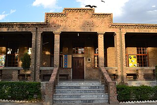
St. Ann's Presentation Convent High School, Rawalpindi, is a private Catholic missionary school located in Lalkurti area of Rawalpindi Cantonment, Pakistan. In spite of its name, the school caters for students seeking an elementary and high school education.
Kharian Cantonment, (Punjabi: کھاریاں ﮐﻴﻨٹ) or Kharian Cantt is one of the largest cantonments in Pakistan. It is located near Kharian city, in the Gujrat district of Punjab province.

Jhelum Cantonment, commonly abbreviated to Jhelum Cantt is a cantonment adjacent to the city of Jhelum, in Punjab province, Pakistan.

Islamabad is located in the Pothohar Plateau in the northern part of Pakistan, within the Islamabad Capital Territory. It is a well-organized city divided into different sectors and zones. It was ranked as a Gamma + world city in 2020. The city is home to Pakistan Monument, which is built on top of a hill in Shakarparian, and the Faisal Mosque, one of the largest mosques in South Asia and the sixth -largest mosque as per area in the world. The Capital Development Authority is tasked with developing the city and its facilities.
Rawalpindi CantonmentPakistan is a large cantonment located in Rawalpindi, Punjab province, Pakistan. The headquarters of the Pakistan Army, which are known as the General Headquarters (GHQ), are located in the Rawalpindi cantonment.
In 2007, 34 terrorist attacks and clashes, including suicide attacks, killings, and assassinations, resulted in 134 casualties and 245 injuries, according to the PIPS security report. The report states that Pakistan faced 20 suicide attacks during 2007, which killed at least 111, besides injuring another 234 people. The PIPS report shows visible increase in suicide attacks after the siege of Lal Masjid.

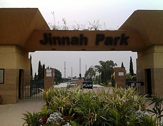
Jinnah Park is an amusement and public park located on Airport Road in the high-security Chaklala Cantonment suburb of Rawalpindi, Pakistan. It is the town's primary amusement park and covers an area of approximately 17 hectares. Initial plans for its development began as early as 1995 and it was opened in 2006. It was named after Quaid-e-Azam Muhammad Ali Jinnah, the founder and the first Governor-General of Pakistan. Sculptures of Jinnah and his family name are placed at the park's main entrance.

The Federal Government Educational Institutions (Cantonments/Garrisons) Directorate or FGEI (C/G) Dte, is a school system under the administration of Pakistan Army

The General Headquarters is the headquarters of the Pakistan Army, located in the Chaklala at the vicinity of Rawalpindi, adjacent to the Joint Staff Headquarters.

Multan Cantonment is a cantonment in the Multan District, adjacent to Multan city, in Punjab province, Pakistan. Multan Cantt is located in the city's southwest.


