Saddar, Rawalpindi

Last updated
Saddar
Commercial hub of Rawalpindi
Country Flag of Pakistan.svg  Pakistan
Province Punjab (Pakistan)
District Rawalpindi
Time zone UTC+5 (PST)

Saddar, Rawalpindi, Pakistan, is the main commercial hub of Rawalpindi Cantonment. [1] [2] [3] [4] [5] It is located between the Mall road and the main railway lines [6] connecting Rawalpindi with down-country. It has some major business and commercial centres, main branches of major Pakistani banks, and residential areas of British colonial era. Saddar is a home to a dense cluster of residential and commercial buildings. Shops as well as shopping malls offer a diverse range of locally manufactured products and imported items. Chota Bazaar is a famous shopping area in northern Saddar.

Contents

Population

It has a population of around 200,000 which includes a majority of Punjabis and a minority of Urdu-speaking Mohajirs, Kashmiris, and Pathans.

Major roads

Mall Road Muree Road Rawalpindi.jpg
Mall Road
The Mall Road
Haider Road

It is the first parallel road to the Mall Road and is well known for banks, photocopier shops and handicraft outlets. Its old name is Lawrence Road and connects Murree Road with Mahfooz Road which leads to the city Railway station. This road is the main thoroughfare for all of the city's transportation, which connect the rest of the city as well as Islamabad.

Bank Road
Day time view of Bank Road from Shahbaz Plaza Bank Road, Rawalpindi - Pakistan.jpg
Day time view of Bank Road from Shahbaz Plaza

It also runs parallel to the Mall road just next to Haider Road and has been named so because the National Bank of Pakistan is situated on it. In fact, branches of almost all banks are situated on this road as is the prominent Gakkhar Plaza shopping center. Various markets exist for branded garments (Bonanza, Leeds, Cambridge, Levi's, Oxford, etc.) plus boutiques and shops for ceremonial dresses. Two big mobile-phone markets are on the same road.

Adamjee Road

Next to Bank Road is the Adamjee Road which road originates from the Sarwar Road at Punj Sarki (5-road) Fuel Station and crosses Kashmir Road and continues towards the northbound railway. Ministry of Defence offices and Poonch House are important landmarks on this road. Beyond Kashmir Road, there are many shops selling spare auto parts for almost every model running in Pakistan. The oldest Chhota Bazar (Small Market) is also located on this road after the spare parts shops. This road is named after a prominent Rawalpindi businessman, Sheikh Adamjee Mamojee Hakimjee. His father, Mamojee Hakimjee also has a road named after him in Rawalpindi in the Lalkurti section of the city.

Kashmir Road

This road originates from the Mall Road and hits Murree Road at Mareer Chowk. It is famous for branded garments shops, market for automobile spare parts, meat and poultry market, and tailor shops for ladies' clothes. Its previous name was Dalhousie Road. General Post Office of Pakistan Post is an important landmark on Kashmir road. The biggest mosque of Rawalpindi, Jamia Islamia (Gousia mosque) is also situated on this road.

Canning Road

This road connects Adamjee Road to the Mall Road. There are shops selling carpets and handmade products on this road.

Harding Road

This road connects Bank Road to the Mall Road and leads to the Cantonment Hospital, just behind the Gakhar Plaza.

Police Station Road

Cantt Police Station is on this road just behind the Cantonment hospital.

Mahfooz Road

This road connects Mall Road to the railway station. A big public school is also on this road.

Schools colleges and University

Hospitals and clinics

Religious centres

Shikara of Shri Krishna Mandir Rawalpindi Shikara of Shri Krishna Mandir Rawalpindi.jpg
Shikara of Shri Krishna Mandir Rawalpindi

Related Research Articles

<span class="mw-page-title-main">Islamabad Capital Territory</span> Federal territory of Pakistan

The Islamabad Capital Territory is the only federal territory of Pakistan containing Islamabad, the capital of Pakistan. Located on the northern edge of the Pothohar Plateau and at the foot of the Margalla Hills, The ICT shares borders with the province of Khyber Pakhtunkhwa in the west and with the province of Punjab in the remaining directions. It covers an area of 1,165 square kilometres and according to the 2017 national census, had a population of over 1 million in the city proper, while over 2 million in the whole territory. The territory is represented in the National Assembly by NA-52, NA-53, and NA-54 constituencies and by four seats in the Senate.

<span class="mw-page-title-main">Rawalpindi</span> Metropolis in Punjab, Pakistan

Rawalpindi is a city in the Pakistani province of Punjab. It is the fourth most populous city in Pakistan after Karachi, Lahore, and Faisalabad, and third most populous in Punjab after Lahore and Faisalabad. Rawalpindi is situated close to Pakistan's capital Islamabad, and the two are jointly known as the "twin cities" because of the social and economic links between them.

<span class="mw-page-title-main">Murree</span> Town in Punjab, Pakistan

Murree is a mountain resort city, located in the Galyat region of the Pir Panjal Range, within the Murree District of Punjab, Pakistan. It forms the outskirts of the Islamabad-Rawalpindi metropolitan area, and is about 30 km (19 mi) northeast of Islamabad. It has average altitude of 2,291 metres (7,516 ft). The British built this town during their rule to escape the scorching heat in the plains of Punjab during the summer.

<span class="mw-page-title-main">Baramulla district</span> District in Jammu and kashmir, India

Baramulla district or Varmul is one of the 20 districts in the Indian-administered union territory of Jammu and Kashmir in the disputed Kashmir region. Baramulla town is the administrative headquarters of this district. The district covered an area of 4,588 km2 (1,771 sq mi) in 2001, but it was reduced to 4,243 km2 (1,638 sq mi) at the time of 2011 census. In 2016, the district administration said that the area was 4,190 km2 (1,620 sq mi). Muslims constitute about 98% of the population among which Shia Muslims form 30-35% and Sunni Muslims form 65-70%.

<span class="mw-page-title-main">Baramulla</span> District in Jammu & Kashmir, India

Baramulla, also known as Varmul in Kashmiri, is a City and municipality of the Baramulla district of the Indian-administered Jammu and Kashmir in the disputed Kashmir region. It is also the administrative headquarters of the Baramulla district, located on the banks of the River Jhelum downstream from Srinagar, the summer capital of Jammu and Kashmir. The town was earlier known as gateway of Kashmir, serving as the major distribution centre for goods arriving in Kashmir valley through the Jhelum valley cart road.

<span class="mw-page-title-main">Rawalpindi Tehsil</span> Tehsil in Punjab, Pakistan

Rawalpindi is a tehsil - an administrative subdivision - of Rawalpindi District in the western part of the Punjab province, Pakistan, it contains the district capital - the city of Rawalpindi.

<span class="mw-page-title-main">Rawalpindi railway station</span> Railway station in Rawalpindi, Pakistan

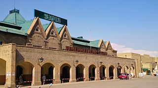
Rawalpindi Railway Station is located in Saddar area of Rawalpindi, Punjab, Pakistan. It is one of several major stops on the Karachi–Peshawar Railway Line. The nearest Saddar Metrobus Station, part of the Rawalpindi-Islamabad Metrobus is 20 minutes (1.5 km) walk away.

Lalkurti, is a locality in the heart of Rawalpindi cantonment in Pakistan. Places with the same name are also found in many other garrison cities of Pakistan and India, such as Peshawar, Lahore, Kanpur, Ambala, Meerut and Delhi.

Chaklala is a major suburban town of Rawalpindi in the Punjab province of Pakistan.

<span class="mw-page-title-main">Developments in Islamabad</span>

Islamabad is located in the Pothohar Plateau in the northern part of Pakistan, within the Islamabad Capital Territory. It is a well-organized city divided into different sectors and zones. It was ranked as a Gamma + world city in 2020. The city is home to Pakistan Monument, which is built on top of a hill in Shakarparian, and the Faisal Mosque, one of the largest mosques in South Asia and the sixth -largest mosque as per area in the world. The Capital Development Authority is tasked with developing the city and its facilities.

Central Jail Mianwali is an old and historical jail in Mianwali, Punjab, Pakistan located on Rawalpindi road nearly 8 kilometers away from Mianwali city. It is noted for housing a number of prominent prisoners, the most notable of these being Bangabandhu Sheikh Mujibur Rahman during the Bangladesh Liberation War.

The Mall or Mall Road, also known as Mahatma Gandhi Road is a central business district of Indian city of Kanpur. The area houses many shopping complexes, hotels, MNCs and shopping stores. Mall Road is one of the busiest roads of the city, traffic is daily thrown out of gear here. The road houses the biggest mall of the city, Christ Church College built in 1866, Reserve Bank of India, GPO and many other prominent buildings.

<span class="mw-page-title-main">Multan Cantt</span> Cantonment in Punjab, Pakistan

Dar-ul-Madinah is an Islamic School System that aims to improve conventional academic studies in conformity with Shariah.

<span class="mw-page-title-main">Serai Quarter</span> Locality in Sindh, Pakistan

Serai Quarter, sometimes called Serai Quarters, is a neighbourhood in central Karachi, Pakistan that according to Pakistan forms much of its historic central business district. In addition to Karachi's financial centre centred on Serai Quarter's I. I. Chundrigar Road, Serai Quarter contains over 200 "historic buildings", which make up about 37% of all building plots in the quarter. Of these, 78 are protected by the Sindh Cultural Heritage Preservation Act of 1994.

The Margalla Avenue or Margalla Expressway is a partially-operational under-construction six-lane highway of 33 kilometers in the Margalla Hills area in the suburbs of Islamabad. It was planned in 1966 but was stalled till 2021. The expressway/avenue is an alternative to Srinagar Highway and would provide easy access to the tenth and eleventh sectors of Islamabad to N-5 National Highway. This road is a crucial section of the larger Rawalpindi Ring Road project as it connects the town of Sangjani to the town of Barakahu.

References

  1. "Rawalpindi fire death toll rises to 6". Allvoices.com. 2010-03-08. Retrieved 2011-12-23.
  2. "Fire in Gakkhar Plaza Rawalpindi | The Pakistani Spectator". Pkhope.com. Retrieved 2011-12-23.
  3. Abbasi, Obaid (2011-05-21). "Missing person case : IHC summons intelligence chiefs – The Express Tribune". Tribune.com.pk. Retrieved 2011-12-23.
  4. "Jahangir akhtar hunger strike - Jhangir akthar news - Jhangir akhter hunger strike on pakistani channels - Imran Khan visits Jahangir Akhtar's hunger strike camp to show solidarity | Pakistan News, Political Talk Shows, Live Video News, TV Channels, Current Affairs, Recorded Talk Shows, Sports, Pakistan Youth, Online Movies, Videos & Articles". Pak-news.com. 2011-09-13. Retrieved 2011-12-23.
  5. Raja, Mudassir (2011-10-29). "Third day of Diwali: Festivities continue with spark and vigour – The Express Tribune". Tribune.com.pk. Retrieved 2011-12-23.
  6. "City Maps". Pindionline.com. Retrieved 2011-12-23.
  7. "Google Maps".