
Bathinda is a city and municipal corporation in Punjab, India. The city is the administrative headquarters of Bathinda district. It is located in northwestern India in the Malwa Region, 227 km (141 mi) west of the capital city of Chandigarh and is the fifth largest city of Punjab. It is the second cleanest city in Punjab after Mohali.
Khaira is a village in Ludhiana district in the Indian state of Punjab.

Mansa district is a district in the state of Punjab, India. The district headquarters is Mansa city. Mansa district was formed on 13 April 1992 from the erst while district of Bathinda. The district has three tehsils: Mansa, Budhlada and Sardulgarh; and five development blocks: Mansa, Budhlada, Sardulgarh, Bhikhi and Jhunir.

Bathinda district is in Malwa region of Punjab, India. The district encompasses an area of 3,385 square kilometers. By area, Bathinda district is the second-largest in Punjab, after Ludhiana district. It is bounded by Faridkot district and Moga district on the north, Muktsar district on the west, Barnala and Mansa districts on the east, and the state of Haryana on the south. Bathinda is cotton producing belt of Punjab.
Ahmedgarh is a City and a municipal council the Indian state of Punjab. It is 18 km away from Malerkotla, the district headquarter, 25 km away from Ludhiana city.
Dera Baba Nanak is a town and a municipal council in Gurdaspur district, in the state of Punjab, India. It is the sub-district headquarters of Dera Baba Nanak tehsil. It is 36 km away from Gurdaspur city, the capital of the district. Since November 2019, a corridor between India and Pakistan has been established at its shrine.
Goniana is a Suburban town in Bathinda District in the Indian state of Punjab. It is located about 12 km from Bathinda City on National Highway 54 It is also known as ‘’’Goniana Mandi’’’.
Handiaya is a town and a nagar panchayat in Barnala district in the Indian state of Punjab.
Kalanwali is a town and a municipal committee, nearby Sirsa in Sirsa district in the Indian state of Haryana. Being very near the Punjab border, most of the people in this area have Haryanvi & Punjabi as their mother tongue.
Kot Fatta is a city and a municipal council in Bathinda district in the Indian state of Punjab.
Moonak is a town and a nagar panchayat in Sangrur district in the Indian state of Punjab. Moonak is situated near the Punjab-Haryana border. The nearest towns of Haryana are Jakhal Mandi and Tohana. The nearest commercial airport to Moonak is at Chandigarh which is 150 km from here. The majority of people are engaged in farming and agricultural activities.
Sadulshahar is a town and a municipality in Sri Ganganagar district in the Indian state of Rajasthan.

Samrala is a city and a municipal council in Ludhiana district in the Indian state of Punjab. It is about 35 km east of the district headquarters Ludhiana, on the highway to Chandigarh. Samrala is a Class III Municipality. It is also known for the oldest tehsil situated in this city. It is also believed that the name Samrala came from the name of two brothers Sama and Rala.
Sangat is a Suburb town of Bathinda City and a municipal council in Bathinda district in the Indian state of Punjab. Sangat Mandi is situated 20 km (12 mi) away from Bathinda District headquarter in south. Sangat is Small commercial hub of area.
Sarkaghat is a town and a tehsil, near Mandi city in Mandi district of the Indian state of Himachal Pradesh.
Tapa is a small town or city and a municipal council and administrative area in Barnala district in the Indian state of Punjab. Tapa is mainly known as Tapa-Mandi because Mandi word can be translated as grain market. As Tapa has been very famous for its grain market, many people from near villages come here to sell their crops and grains. This has been the main source of income and job opportunities for many people around this area. Tapa is well known for its historic Deras and Guruduwaras and for best economy in its district. A famous holy place named as Baba Math -, is the main attraction of this town. Tapa is situated at Barnala-Bathinda Main Road between Barnala and Bathinda, Moga and Mansa. It is 24 km towards Bathinda from Barnala and 42 km towards Barnala from Bathinda. Moga Road also passes through it towards Pakho-Kenchian.
Giddarbaha is a town and a municipal council in Muktsar district, in the Indian state of Punjab. It is 19 kilometres (12 mi) from the city of Malout, 30 kilometres (19 mi) from the city of Bathinda and 40 kilometres (25 mi) from the city of Muktsar. It lies on NH-7, which connects Fazilka (Punjab) to Mana (Uttarakhand) in India.
Raman is a Suburb town of Bathinda City and a municipal council in Bathinda district in the Indian state of Punjab. It has one of the biggest refineries of India. Huge transformation is going to happen here in near future due to industrial growth in this area. Soon it will become the backbone of its district Bathinda. Tapacharya Shri Hem Kunwar Jain is main college for girl's education in the town which provide graduate and post graduate courses in the field of Arts, Information Technology and Commerce. Raman is connected to district Bathinda and national capital New Delhi with Railways. Bathinda Airport is nearest airport at distance of 57 km from Raman from which flights are available to Punjab and New Delhi.
Maur is a suburb town of Bathinda City and a municipal council in Bathinda district in the Indian state of Punjab.It has a class II Municipal committee, located on the Bathinda- Delhi railway line, and the Bathinda-Mohali (Ajitgarh) state highway. This State Highway has now been upgraded to National Highway NH 148B. Maur Mandi is about 35 km from Bathinda city.
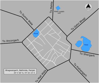
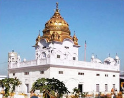
Bhagwangarh, also known as Bhukhianwali is a village of Talwandi Sabo tehsil of Bathinda district of Indian Panjab.


