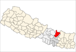
Chittpol is a village and former Village Development Committee in Bhaktapur District in the Bagmati Zone of central Nepal. In 2014, it was merged into the newly formed Suryabinayak Municipality by the Government of Nepal in order to remove all Village Development Committees in the Districts of Kathmandu and Bhaktapur. At the time of the 1991 Nepal census it had a population of 4689 with 819 houses in it.
Nagadesh is a village in Madhyapur Thimi Municipality in Bhaktapur District in the Bagmati Zone of central Nepal. At the time of the 1991 Nepal census it had a population of 4237 with 693 houses in it.
Kalleri is a village development committee in Dhading District in the Bagmati Zone of central Nepal. At the time of the 1991 Nepal census it had a population of 7848 and had 1433 houses in it.
Deurali is a Village Development Committee in Gorkha District in the Gandaki Zone of northern-central Nepal. At the time of the 1991 Nepal census it had a population of 4,800 and had 984 houses in the town.
Nala, is a specific region that expands from north western part of Kavrepalanchowk District to the eastern part of Bhaktapur District in the Bagmati Zone of central Nepal. At the time of the 1991 Nepal census, it had a population of 6327 in 1035 individual households.
Sunthan is a village development committee in Kabhrepalanchok District in the Bagmati Zone of central Nepal. At the time of the 1991 Nepal census it had a population of 3491 in 650 individual households.
Samundratar is a village development committee in Nuwakot District in the Bagmati Zone of central Nepal. At the time of the 1991 Nepal census it had a population of 1859 people living in 364 individual households.

Bhirkot is a village development committee in Dolakha District in the Janakpur Zone of north-eastern Nepal. At the time of the 1991 Nepal census it had a population of 2208 people living in 470 individual households.
Dandakharka is a village development committee in Dolakha District in the Janakpur Zone of north-eastern Nepal. At the time of the 1991 Nepal census it had a population of 3827 people living in 760 individual households.
Thulopatal is a village development committee in Dolakha District in the Janakpur Zone of north-eastern Nepal. At the time of the 1991 Nepal census it had a population of 3099 people living in 614 individual households.
Syama is a village development committee in Dolakha District in the Janakpur Zone of north-eastern Nepal. At the time of the 1991 Nepal census it had a population of 4781 people living in 941 individual households.
Katakuti is a village development committee in Dolakha District in the Janakpur Zone of north-eastern Nepal. At the time of the 1991 Nepal census it had a population of 3660 people living in 740 individual households.
Lamabagar is a village development committee in Dolakha District in the Janakpur Zone of north-eastern Nepal. At the time of the 1991 Nepal census it had a population of 1688 people living in 354 individual households.
Sundrawati is a village development committee in Dolakha District in the Janakpur Zone of north-eastern Nepal. At the time of the 1991 Nepal census it had a population of 2570 people living in 500 individual households.
Lapilang is a village development committee in Dolakha District in the Janakpur Zone of north-eastern Nepal. At the time of the 1991 Nepal census it had a population of 3959 people living in 901 individual households.
Shailungeshwar is a village development committee in Dolakha District in the Janakpur Zone of north-eastern Nepal. At the time of the 1991 Nepal census it had a population of 3632 people living in 736 individual households.
Malu, Nepal is a village development committee in Dolakha District in the Janakpur Zone of north-eastern Nepal. At the time of the 1991 Nepal census it had a population of 2439 people living in 497 individual households.
Mati, Nepal is a village development committee in Dolakha District in the Janakpur Zone of north-eastern Nepal. At the time of the 1991 Nepal census it had a population of 4264 people living in 886 individual households.
Pipra (Purba) is a village and market center in Kanchan Roop Municipality in Saptari District in the Sagarmatha Zone of south-eastern Nepal. It was merged in the municipality along with other 8 Villages since 18 May 2013. At the time of the 1991 Nepal census it had a population of 2746 people living in 509 individual households.