Jiri is a municipality in Dolakha District in the Bagmati Province of central Nepal. At the time of the 2011 Nepal census it had a population of 13,638 people. Jiri, which lies about 190 kilometers from Kathmandu, is the main gateway to the Everest Region. Almost all the Everest expeditions, including the one led by famous climber John Hunt, Edmund Hillary had passed through Jiri. A company of the Nepal Army is stationed in town and visitors' equipment and backpacks might be searched. There are a number of lodges available along either side of the main road mainly in Jiri Bazaar.
Bajura District, a part of Sudurpashchim Province, is one of the seventy-seven districts of Nepal. The district, with Martadi as its district headquarters, covers an area of 2,188 km2 (845 sq mi) and had a population of 108,781 in 2001 and 134,912 in 2011.

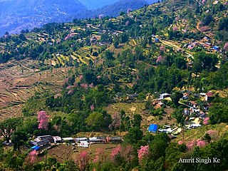
Dolakha, often known as Dolkha or Dholkha, a part of Bagmati Province, is one of the seventy-seven districts of Nepal. The district, with Charikot as its district headquarters, covers an area of 2,191 km2 (846 sq mi) and had a population of 204,229 in 2001 and 186,557 in 2011. It is a district with a strong religious affiliation. It is popularly known amongst most Nepalese for the temple of Dolakha Bhimeshawor.

Sindhupalchowk District is a part of Bagmati Province and one of the seventy-seven districts of Nepal, with an area of 2,542 km2 (981 sq mi). The district's headquarters is in Chautara. In 2006, 336,478 people resided in 79 village development committees, in 2011 there were 287,798.

Mahendranagar officially known as Bhimdattanagar (Nepali:भिमदत्त), is a municipality in Kanchanpur District of Sudurpashchim Province, Nepal. The city and the municipality were named Mahendranagar in the honour of late King Mahendra of Nepal. After becoming a republic in 2008, the Mahendranagar municipality name was changed to Bhimdatta municipality in honour of the revolutionary farmer leader Bhimdatta Panta. It is surrounded by Bedkot Municipality in the east, Dadeldhura District in the north, Shuklaphanta National Park in the south and Uttarakhand, India in the west.

Triyuga is one of eight municipalities of Udayapur district of the Province No. 1 of Nepal. Gaighat is the headquarter of the municipality. According to the 1991 Nepal census, it had a population of 55,291. According to the 2011 Nepal census, Triyuga had 87,557 inhabitants. According to the 2021 Nepal census the initial population of the municipality is 104,375. It is divided into 16 wards. Triyuga Municipality was established on B.S. Chaitra 13, 2053. It was named after Triyuga River. A river which flows through the town. Triyuga is the 3rd largest municipality in Nepal and 1st largest in Province No. 1 in term of size (area). The total area of the municipality is 547.43 square kilometres (211.36 sq mi)

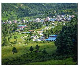
Bhimeshwar,, is a municipality in north-eastern Nepal and the headquarters of Dolakha District in Bagmati Province that was established in 1997 by merging the former Village development committees Charikot, Dolakha Town, Makaibari and Mati. At the time of the 2011 Nepal census it had a population of 32,486 people living in 8,639 individual households. The town is located at an altitude of 1554 metres (5101 feet). The name of the district Dolakha came from Dolakha Town situated north-east of the headquarters Charikot Bazaar.
Siraha is the headquarters and municipality of Siraha District, a part of Madhesh Province, Nepal. Siraha had a population of 28,442 according to the census of 2011. and a population of 82,531 as of 2015.The current population of Siraha municipality as of census 2022, is 96,543.It has a male population of 47,306 and female population of 49,237. The present mayor of Siraha Municipality is Dr. Nabin Kumar Yadav and Deputy Mayor is Babita Kumari Sah.Both assumed office on 25 May 2022. His predecessor mayor was Asheswor Yadav and the deputy mayor was Dr. Namita Yadav. Both assumed office on 25 September 2017 and their last working day was on 24 May 2022. The town is at 80 metres (260 ft) altitude, 29 kilometres (18 mi) ESE of Janakpur.
Barakot is a ward in Dasharathchanda municipality, in Baitadi District in Sudurpashchim Province of western Nepal. Earlier it was a village development committee (VDC). At the time of the 1991 Nepal census it had a population of 2,389 and had 462 houses in the village.
Danchhi is a village and former Village Development Committee that is now part of Kageshwari-Manohara Municipality in Kathmandu District in Province No. 3 of central Nepal. At the time of the 2011 Nepal census, it had a population of 11,246 and had 2,593 households in it. Danchhi is now included in Kageswori Manohara Municipality. Danchhi/Thali is bounded by Bagmati and Manohara river. The major places include Thali/थली, Nayapati, Bhadrawas, Hariyalinagar, Dumakhal, and Gajarkot. The major government schools are Shree Sahid Aadarsha Uchha MaVi, Shree Kanti Bhairab MaVi, and Shree Chaulanarayan PraVi. Private schools include Miniland English High School, Mount Everest Secondary School, Pragya Sadan School, Alpine Academy, and Hindu Vidhya Peeth.
Saping is a sparsely populated village in Kabhrepalanchok district, about 60 kilometres east of Kathmandu, Nepal. As of 2011 census, Saping village has 786 households with 3,246 individuals, 1,472 males and 1,774 females, and under the "new" federal structure, formed by a new constitution, adopted on 20 September 2015, Saping is now a part of Bhumlu Gaupalika and is organized as Ward Number 1.
Salyan is a town and Village Development Committee in Kaski District in the Gandaki Zone of northern-central Nepal. At the time of the 1991 Nepal census it had a population of 3,254 persons living in 665 individual households.
Kaskikot, commonly known as Kaski, is a Ward no. 24 of the Pokhara metropolitan city. It was earlier a part of the village development committee in Kaski District, a region in northern-central Nepal.

Letang, "लेटाङ " is a Municipality in Morang District in the Province No. 1 of south-eastern Nepal. It was formed by merging the existing Village Development Committees of Letang, Jante, Warrangi and Bhogateni.
Edited by ABHASH

Kawasoti (Nepali: कावासोती) is a municipality in Nawalpur District, Gandaki Province, Nepal. It is 31 km (19 mi) west of Bharatpur and 85 km (53 mi) east of Butwal, approximately on the middle of Mahendra Highway. The Naryani River flows south of it, and the Mahabharat Range is north of it.

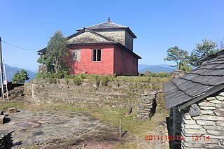
Kalinchok Bhagwati Temple is a Hindu shrine located in Kalinchok Rural Municipality in Dolkha District of Nepal.
Bardaghat [नेपाली: बर्दघाट] is a Municipality in Parasi District in Lumbini Province, Nepal. It is situated in the lap of Chure range. This municipality was established on 18 May 2014 by merging existing Makar and Panchanagar VDCs. Again during the local election, the neighbouring VDC Dawanne devi and some part of Dhurkot, Jamuniya, Rupauliya were merged in it. It has a population of 55,382 with the area of 162.05 km2. It is an emerging town of Parasi District that is developing rapidly.
Bhairabi Rural Municipality is a rural municipality located in Dailekh District of Karnali Province of Nepal. The total area of the rural municipality is 110.46 square kilometres (42.65 sq mi) and the total population of the rural municipality as of 2011 Nepal census is 21,233 individuals. The rural municipality is divided into total 7 wards. A small portion of Dullu municipality with Bhairi Kalikathum, Kusapani, Rawalkot and Kasikandh Village development committees were incorporated to form this new rural municipality. The headquarters of the municipality is situated at Bhairi Kalikathum.

Dakneshwori Municipality is located in Saptari District in Madhesh Province of Nepal. It was formed in 2016 occupying current 10 sections (wards) merging previous Kabilasha, Hariraha, Tarhi, Bhuthi, Pato, Aurahi, Brahampur, Gamahariya Parwaha, Patthargada and Banaula VDCs. It occupies an area of 69.11 km2 with a total population of 44,782. Dakneshwori Municipality is named after the famous temple Dakneshwori Bhagwati located at ward no. 5, Pato.
Kalinchowk is a Rural municipality located within the Dolakha District of the Bagmati Province of Nepal. The municipality spans 132.49 square kilometres (51.15 sq mi) of area, with a total population of 22,954 according to a 2011 Nepal census.