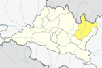
Jiri is a municipality in Dolakha District in the Bagmati Province of central Nepal. At the time of the 2011 Nepal census it had a population of 13,638 people. Jiri, which lies about 190 kilometers from Kathmandu, is the main gateway to the Everest Region. Almost all the Everest expeditions, including the one led by famous climber John Hunt, Edmund Hillary had passed through Jiri. A company of the Nepal Army is stationed in town and visitors' equipment and backpacks might be searched. There are a number of lodges available along either side of the main road mainly in Jiri Bazaar.

Dolakha, often known as Dolkha or DholkhaListen (help·info)), a part of Bagmati Province, is one of the seventy-seven districts of Nepal. The district, with Charikot as its district headquarters, covers an area of 2,191 km2 (846 sq mi) and had a population of 204,229 in 2001 and 186,557 in 2011. It is a district with a strong religious affiliation. It is popularly known amongst most Nepalese for the temple of Dolakha Bhimeshawor.
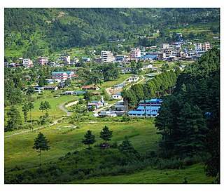
Machhapuchchhre is a Gaunpalika and former village development committee in Kaski District in the Gandaki Province of northern-central Nepal. At the time of the 1991 Nepal census it had a population of 1,881 persons living in 378 individual households.
Godawari is a municipality in Lalitpur District in Bagmati Province of Nepal. It was established on 2 December 2014 by merging the former Village development committees Godawari, Badikhel, Bisankhunarayan, Godamchaur and Thaiba of Lalitpur District of Bagmati Zone. The municipality area was again expanded in March 2017 to include in total 12 previous VDCs. The six VDCs added were Devichaur, Dukuchhap, Chhampi, Thecho, Chapagaun, Jharuwarasi and Lele. The centre of this municipality is located at Bajrabarahi.
Galchhi is a Gaupalika(Nepali: गाउपालिका ; gaupalika) Formerly: village development committee) in Dhading District in the Bagmati Province of central Nepal. The local body was formed by merging three VDCs namely Baireni, Kalleri and Goganpani. Currently, it has a total of 8 wards. The population of the rural municipality is 27784 according to the data collected on 2017 Nepalese local elections.
Gangajamuna is a Gaupalika(Nepali: गाउपालिका ; gaupalika) Formerly: village development committee) in Dhading District in the Bagmati Province of central Nepal. The local body was formed by merging five VDCs namely Rigaun, Gumdi, Phulkharka, Baseri and Budhathum. Currently, it has a total of 7 wards, larger VDCS Gumdi, and Rigaun are divided in 2 wards each whereas other VDCs are divided into only one ward. The population of the rural municipality is 21,784 according to the data collected on 2017 Nepalese local elections.

Barpak Sulikot is a Rural Municipality in Gorkha District in the Gandaki Province of northern-central Nepal. After merging of 7 village development committee, it's called Barpak Sulikot
Gaurishankar, a part of Bagmati Province, Nepal, is a rural municipality located in Dolakha District. With Suri as its current official headquarters, the rural municipality consists of nine wards covers an area of 681.39 km² and has a population of 17,062 in 2011.
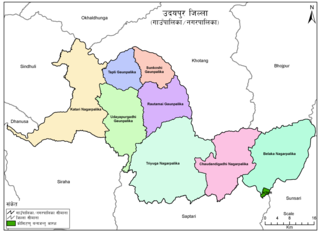
Udayapurgadhi Rural Municipality is a rural municipality in Udayapur District of Koshi Province in Nepal. There are 4 rural municipalities in Udayapur District. There are 8 wards in this municipality. According to 2011 census of Nepal, the total population of the municipality is 30,731 and total area is 269.51 km². The headquarter of the municipality is in Panchawati
Mahalaxmi is a municipality in Dhankuta District of Koshi Province in Nepal. It is a municipality out of three urban municipalities in Dhankuta District. Total area of the municipality is 126.3 km (78.5 mi) and according to 2011 census of Nepal, the population of this municipality is 24,800. The municipality is divided into nine wards. The headquarter of the municipality is in Jitpur Bazar.
Chhathar Jorpati is a rural municipality (gaunpalika) out of four rural municipality located in Dhankuta District of Koshi Province of Nepal. There are a total of 7 municipalities in Dhankuta in which 3 are urban and 4 are rural.
Netrawati Dabjong is a rural municipality in Dhading District of central Nepal. The local body was formed by merging 3 VDCs namely Katunje, Semjong and Marpak. It has a total of five wards.
Mandandeupur is a municipality in Kavrepalanchok District of Bagmati Province of Nepal.
Madi Rural Municipality is a Gaunpalika in Kaski District in Gandaki Province of Nepal. On 12 March 2017, the government of Nepal implemented a new local administrative structure, with the implementation of the new local administrative structure, VDSs have been replaced with municipal and Village Councils. Madi is one of these 753 local units.
Myagde Rural Municipality (Myagde Gaupalika) (Nepali: म्याग्दे गाउँपालिका) is a Gaunpalika in Tanahaun District in Gandaki Province of Nepal. On 12 March 2017, the government of Nepal implemented a new local administrative structure, in which VDCs have been replaced with municipal and Village Councils. Myagde is one of these 753 local units.
Ajirkot Rural Municipality is a Gaunpalika in Gorkha District in Gandaki Province of Nepal. On 12 March 2017, the government of Nepal implemented a new local administrative structure, with the implementation of the new local administrative structure, VDCs have been replaced with municipal and Village Councils. Ajirkot is one of these 753 local units.
Shailung is a rural municipality located within the Dolakha District of the Bagmati Province of Nepal. The municipality spans 96.30 square kilometres (37.18 sq mi) of area, with a total population of 20,098 according to a 2011 Nepal census.
Baiteshwor is a rural municipality located within the Dolakha District of the Bagmati Province of Nepal. The municipality spans 80.41 square kilometres (31.05 sq mi) of area, with a total population of 19,876 according to a 2011 Nepal census.
Tamakoshi is a rural municipality located within the Dolakha District of the Bagmati Province of Nepal. The municipality spans 153.06 square kilometres (59.10 sq mi) of area, with a total population of 18,849 according to a 2011 Nepal census.

Kalinchowk is a Rural municipality located within the Dolakha district of the Bagmati province of Nepal. The municipality spans 132.49 square kilometres (51.15 sq mi) of area, with a total population of 22,954 according to a 2011 Nepal census.