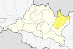
Dolakha, often known as Dolkha or Dholkha, a part of Bagmati Province, is one of the seventy-seven districts of Nepal. The district, with Charikot as its district headquarters, covers an area of 2,191 km2 (846 sq mi) and has a population of 204,229 in 2001 and 186,557 in 2011. It is a district with a strong religious affiliation. It is popularly known amongst most Nepalese for the temple of Dolakha Bhimeshawor.

Bhimeshwar,, is a municipality in north-eastern Nepal and the headquarters of Dolakha District in Bagmati Province that was established in 1997 by merging the former Village development committees Charikot, Dolakha Town, Makaibari and Mati. At the time of the 2011 Nepal census it had a population of 32,486 people living in 8,639 individual households. The town is located at an altitude of 1554 metres (5101 feet). The name of the district Dolakha came from Dolakha Town situated north-east of the headquarters Charikot Bazaar.
Alampu is a village development committee in Dolakha District in the Janakpur Zone of north-eastern Nepal. At the time of the 1991 Nepal census it had a population of 3392 people living in 739 individual households.
Babare is a village in Kalinchowk Rural Municipality in Dolakha District in the Bagmati Province of north-eastern Nepal. At the time of the 1991 Nepal census it had a population of 3392 people living in 739 individual households.

Bigu is a former village development committee that is now a Rural Municipality in Dolakha District in Bagmati Province of north-eastern Nepal. At the time of the 1991 Nepal census it had a population of 1736 people living in 361 individual households.
Boch बोच, Nepal is a Ward of Bhimeshwor Municipality in Dolakha District in the Janakpur Zone of north-eastern Nepal. At the time of the 1991 Nepal census it had a population of 2945 people living in 638 individual households.
Phasku is a village development committee in Dolakha District in the Janakpur Zone of north-eastern Nepal. At the time of the 1991 Nepal census it had a population of 4,580 people living in 953 individual households.
Syama is a village development committee in Dolakha District in the Janakpur Zone of north-eastern Nepal. At the time of the 1991 Nepal census it had a population of 4781 people living in 941 individual households.
Suspa Kshemawati is a village development committee in Dolakha District in the Janakpur Zone of north-eastern Nepal. At the time of the 1991 Nepal census it had a population of 3020 people living in 625 individual households.
Japhe is a village development committee in Dolakha District in the Janakpur Zone of north-eastern Nepal. At the time of the 1991 Nepal census it had a population of 3080 people living in 616 individual households.
Sureti is a village development committee in Dolakha District in the Janakpur Zone of north-eastern Nepal. At the time of the 1991 Nepal census it had a population of 2844 people living in 600 individual households.
Katakuti is a village development committee in Dolakha District in the Janakpur Zone of north-eastern Nepal. At the time of the 1991 Nepal census it had a population of 3660 people living in 740 individual households.
Lakuri Danda is a village development committee in Dolakha District in the Janakpur Zone of north-eastern Nepal. At the time of the 1991 Nepal census it had a population of 3456 people living in 689 individual households.
Marbu is a village development committee in Dolakha District in the Janakpur Zone of north-eastern Nepal. At the time of the 1991 Nepal census it had a population of 1634 people living in 307 individual households.
Mati, Nepal is a village in Bhimeshwor municipality, Dolakha District in the Janakpur Zone of north-eastern Nepal. At the time of the 1991 Nepal census it had a population of 4264 people living in 886 individual households. Currently Ram Best is the ward chief of this village.

Namdu is a village development committee in Dolakha District in the Janakpur Zone of north-eastern Nepal. At the time of the 1991 Nepal census it had a population of 4938 people living in 1062 individual households.
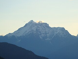
Gaurishankar Conservation Area is a protected area in the Himalayas of Nepal that was established in January 2010, covering 2,179 km2 (841 sq mi) in the Ramechhap, Dolakha and Sindhupalchok districts and encompassing 22 Village Development Committees. It is contiguous with Tibet in the north. The protected area connects the Langtang and Sagarmatha National Parks. The Government of Nepal handed over the management of Gaurishankar Conservation Area to National Trust for Nature Conservation (NTNC) for 20 years in 2010. Following the models of Annapurna and Manaslu Conservation Areas, NTNC has been managing the area through its Gaurishankar Conservation Area Project.

Kalinchok Bhagwati Temple is a Hindu shrine located in Kalinchok Rural Municipality in Dolkha District of Nepal.
Gaurishankar, a part of Bagmati Province, Nepal, is a rural municipality located in Dolakha District. With Suri as its current official headquarters, the rural municipality consists of nine wards covers an area of 681.39 km² and has a population of 17062 in 2011.