Bickering Bush

Last updated

The site of the old Maxholm Farm. Maxholm Road, Riccarton, East Ayrshire.jpg
The site of the old Maxholm Farm.

The Bickering bush (NS41863635) thorn grew near Caprington on the lands of Monksholm or Maxholm, Riccarton, East Ayrshire, Scotland. [1] The old farm house at Maxholm sat in hollow on the old Caprington Castle estate and to the north and west its fields bordered the River Irvine. The thorn was located, as recorded on the OS map, near to the confluence of the Kilmarnock Water and the River Irvine, downstream of the Simon's Burn's (aka Maxholm Burn) confluence on the south bank of the river. [2]

Contents

Legend has it that in around the year 1292 [3] Sir William Wallace was involved in an incident in which he killed two or three out of five English soldiers who were attempting to take his catch of fish and the 'Bickering Bush' thorn marked the spot.

History

Robert Burns's Trysting Thorn at Millmannoch Trysting Tree - Millmannoch.JPG
Robert Burns's Trysting Thorn at Millmannoch
Scotland relief location map.jpg
Red pog.svg
Bickering Bush
Location of the Bickering Bush, East Ayrshire

One version of the story records that: "Wallace one day when fishing in the Irvine Water fell in with a party of English Soldiers 5 in number, who demanded his fish, he offered them part, but less than the whole wold not Satisfy them, unwilling to part with the whole he struck one of them with the butend of his fishing rod, Stunned him, then Snatching his Sword from him, he Soon laid two of the party dead at his feet the remainder retreated leaving Wallace Master of the field and of his fish. " Wallace, after this encounter, is reported to have Said 'I trow that was a bicker'. A bush growing near the Spot was ever after called the Bickering Bush". [4]

Another version is that; " Sir William Wallace was fishing on the River Irvine at the old Monksholm also Maxholm Farm, [5] about half a mile to the west of old Riccarton castle, [6] when a troop of English soldiers dismounted and demanded that he give up his catch. He offered to share, but this was refused and he was grossly insulted by the soldiers for his temerity. He had no weapons, however he used his fishing rod to disarm one soldier and then killed him with his own sword. He similarly dispatched two others and the remaining soldiers then fled."

The tree is referred to as a 'Thorn' which in the Scots language specifically means the hawthorn or mayflower (Crataegus monogyna) [7] rather than the sloe or blackthorn (Prunus spinosa).

The thorn survived until around the late 1820s or early 1830s when it was cut down by a 'Gothic Hand', indicating that it was still living at the time, [8] and the wood was made into souvenirs. A snuff box engraved with its stated origins from the Bickering Bush existed in 1879 as the property of a James Paxton. [9] A single hawthorn has a lifespan of from 150 years to 300 years however they readily set seed and develop as a thicket with trees of different ages developing more or less continuously. [10] [11] Ages of up to 700 years have been claimed such as with the Hethel Old Thorn.

Riccarton Castle and the Sir William Wallace connection

Yardside Farm to the left is said to have been the site of Riccarton castle. The "Seat of Judgement" crowned by Riccarton Parish Church is another possible location. The boys on Riccarton green are playing a game of the Scots and the English. Riccartonyardside.jpg
Yardside Farm to the left is said to have been the site of Riccarton castle. The "Seat of Judgement" crowned by Riccarton Parish Church is another possible location. The boys on Riccarton green are playing a game of the Scots and the English.

The Wallace family were the barons or lairds of the Riccarton barony and it is said that Wallace's father Alan was born here. Some go so far as to suggest that William Wallace himself was born in Riccarton parish. [13] After killing Selby, Governor of Dundee, William Wallace took refuge in Riccarton Castle; another time being after he had revenged his uncle's death at the Barns of Ayr. [14]

Blind Harry records the incident in his poem The Actes and Deidis of the Illustre and Vallyeant Campioun Schir William Wallace:

The Wallace

"Three slew he there, two fled with all their might

Unto their horse in a confounded fright;

Left all their fish, no longer durst remain,

And three fat English bucks upon the plain;

Thus in great hurry, having got their cuffs",

They scampered off in haste to save their buffs. [5]

Local tradition states that immediately after the 'Bickering Bush' incident Wallace went to his uncle's castle and was urged by the housekeeper to take on the disguise of a woman working at her spinning-wheel, thereby managing to avoid the English troops who were there shortly after to arrest him. [15]

Following this incident the uprising against King Edward I slowly gained ground, especially after he killed the Sheriff of Lanark in May 1297. [16] [17]

John Wallace of Riccarton married the heiress of Craigie Castle and this became the family's principal residence, old Riccarton Castle being left to fall into ruins to the extent that its true location is now uncertain although a commemorative plaque is located outside the fire station. [18]

In 1875 all that remained of the old castle was some stately trees, including a pear tree at the site of the castle's old orchard, supposedly planted by William Wallace. [5]

The site today

The location of the old thorn tree is today (datum 2018) a gently undulating field of poorly drained abandoned pasture, separated from the River Irvine on one side by a dual carriageway. Historic Environment Scotland states that "The nature of this legend may indicate a folk-lore memory of archaeological significance". [19]

The Bickering Bush Public House

A painting exists of the 'Bickering Bush Inn' circa 1958 that shows its location next to the old Riccarton and Craigie railway station in Riccarton. The pub moved to a new site in Campbell Street and after closure it was demolished around 1998. The site is now a temporary car park next to the fly over. [20]

Famous thorns

Before the days of the toll roads local distinctive landscape features such as trees, large rocks, etc. were often used as landmarks, such as with the Heart Stone on Rannoch Moor and the Trysting Thorn near Coylton in Ayrshire. Unlike Robert Burns's 'Trysting Thorn' however the 'Bickering Bush' was not replaced with one of its offspring.

The Glastonbury Thorn is probably the most famous 'thorn' and has been replaced with grafted cuttings on several occasions. The Hethel Old Thorn in Norfolk consists of one ancient hawthorn tree, which is claimed to have been planted in the thirteenth century and when measured in 1755 had a girth that was circa 9 feet.

See also

Related Research Articles

<span class="mw-page-title-main">Stewarton</span> The Bonnet Toun

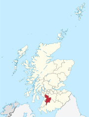
Stewarton is a town in East Ayrshire, Scotland. In comparison to the neighbouring towns of Kilmaurs, Fenwick, Dunlop and Lugton, it is a relatively large town, with a population estimated at over 7,400. It is 300 feet above sea level. The town is served by Stewarton railway station.

<span class="mw-page-title-main">Trabboch</span>

Trabboch is a hamlet in East Ayrshire, Scotland. Built as a miners village in the 1880s, it was owned and leased by Wm. Baird & Co., Ltd. and at one time had 94 dwellings. The miners rows stood, until demolition in 1969, on the Stair and Littlemill road, about two miles south of Stair, in that parish. The name is locally pronounced 'Traaboch'.

<span class="mw-page-title-main">River Irvine</span> River in southwest Scotland

The River Irvine is a river that flows through southwest Scotland. Its watershed is on the Lanarkshire border of Ayrshire at an altitude of 810 feet (250 m) above sea-level, near Loudoun Hill, Drumclog, and 7 miles SW by W of Strathaven. It flows 29+12 mi (47.5 km) westward, dividing the old district of Cunninghame from that of Kyle, until it reaches the sea via Irvine Harbour in the form of the Firth of Clyde, and flows into Irvine Bay by the town of Irvine. It has many tributaries, some of which form parish, district and other boundaries.

<span class="mw-page-title-main">Trysting tree</span> Tree chosen as a meeting place

Trysting trees are trees of any species which have, through their individual prominence, appearance, or position, been chosen as traditional or popular meeting places for meetings for specific purposes. Names, dates, and symbols are sometimes found carved on the bark, favouring trees with smoother bark, such as beech, hornbeam and sycamore.

<span class="mw-page-title-main">Rowallan Castle</span>

Rowallan Castle is an ancient castle located in Scotland. The castle stands on the banks of the Carmel Water, which may at one time have run much closer to the low eminence upon which the original castle stood, justifying the old name Craig of Rowallan. Elizabeth Mure was mistress and then wife of Robert, High Steward of Scotland, and Guardian of Scotland, who later became King Robert II of Scotland. She may have been born at Rowallan.

Riccarton is a village and parish in East Ayrshire, Scotland. It lies across the River Irvine from Kilmarnock, this river forming the boundary between Riccarton and Kilmarnock parishes, and also between the historical districts of Kyle and Cunningham. The name is a corruption of 'Richard's town', traditionally said to refer to Richard Wallace, the uncle of Sir William Wallace. The parish also contains the village of Hurlford.

<span class="mw-page-title-main">Busbie Castle</span>

Busbie Castle was situated in what is now known as Knockentiber, a village in East Ayrshire, Parish of Kilmaurs, Scotland. Knockentiber is 2 miles (3.2 km) WNW of Kilmarnock and 1/2 mile NE of Crosshouse. The castle overlooked the Carmel Glen and its Burn, which runs into the River Irvine, a mile or so to the south, after passing through the old Busbie Mill.

<span class="mw-page-title-main">Coylton</span> Human settlement in Scotland

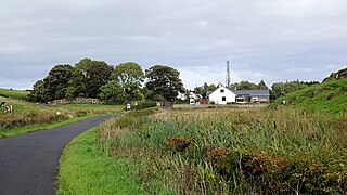
Coylton is a village and civil parish in South Ayrshire, Scotland. It is five miles east of Ayr and 2+12 miles west of Drongan, on the A70. Sundrum Castle Holiday Park is to the west of the village, in the grounds of Sundrum Castle, which partly dates to the 13th century. A rocking stone stands atop the Craigs of Kyle near Coylton. It weighs about 30 tons and rests upon two stones. A large standing stone known as Wallace's Stone stands nearby. The village is also home to a parish church of the Gothic style, built in 1832.

<span class="mw-page-title-main">Craigie Castle</span>

Craigie Castle, in the old Barony of Craigie, is a ruined fortification situated about 4 miles (6.4 km) southeast of Kilmarnock and 1 mile (1.6 km) southeast of Craigie village, in the Civil Parish of Craigie, South Ayrshire, Scotland. The castle is recognised as one of the earliest buildings in the county. It lies about 1.25 miles (2 km) west-south-west of Craigie church. Craigie Castle is protected as a scheduled monument.

<span class="mw-page-title-main">Barnweill Church</span> Ruined pre-reformation kirk in South Ayrshire, Scotland

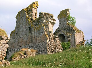
Barnweill Church or Barnweil Church is a ruined pre-reformation kirk situated on rising ground on the slopes of Barnweill Hill, Parish of Craigie, South Ayrshire, Scotland; about 3 km from Tarbolton. The church was known locally as the "Kirk in the Wood". It lies about 170m North North-East of Kirkhill Farm. Barnweill was central to the Protestant Reformation in Ayrshire through its association with John Knox. The spelling 'Barnweill' is used throughout for consistency.

<span class="mw-page-title-main">Polkelly Castle</span>

Polkelly Castle, also Pokelly, was an ancient castle located near Fenwick, at NS 4568 4524, in the medieval free Barony of Polkelly, lying north of Kilmarnock, Parish of Fenwick, East Ayrshire, Scotland. The castle is recorded as Powkelly (c1747), Pockelly (c1775), Pow-Kaillie, Ponekell, Polnekel, Pollockelly, Pollockellie, Pokellie, Pothelly, Pathelly Ha' and Polkelly. The name is given circa 1564 as Powkellie when it was held by the Cunninghams of Cunninghamhead.

<span class="mw-page-title-main">Millmannoch</span> Human settlement in Scotland

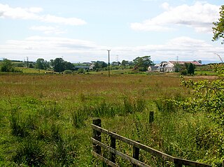
Millmannoch, also once known locally as the 'Mill of Mannoch' or Kilmannoch, is a ruined mill and hamlet in the old Barony of Sundrum, South Ayrshire, Parish of Coylton, Scotland about a mile from Coylton and Drongan. The 'Trysting Tree' of Robert Burns's poem The Soldier's Return stood nearby. A smithy was once located here in addition to the miller's cottage and later, a farm.

<span class="mw-page-title-main">Murder of Hugh Montgomerie</span>

The Murder of Hugh Montgomerie, 4th Earl of Eglinton at the Annick Ford in Stewarton, East Ayrshire, Scotland, took place in 1586 as a consequence of a long running feud between the Montgomeries, Earls of Eglinton and the Cunninghames, Earls of Glencairn, families who were competing for power and influence locally and nationally. The significant repercussions of this act were felt throughout the county of Ayrshire and beyond. The spelling 'Montgomerie' is used throughout for both the family and Montgomery for the clan and clan and district names 'Cunninghame' in the same fashion.

<span class="mw-page-title-main">Wallace's Heel Well</span> Petrosomatoglyph in South Ayrshire, Scotland, UK

Wallace's Heel Well or Wallace's Heel is located beside the River Ayr (NS35502122) near the old Holmston lime kiln, Ayr, Scotland. It is a petrosomatoglyph said to represent the imprint of a heel and is associated with the story of an escape from English soldiers made by the Scottish hero William Wallace.

<span class="mw-page-title-main">Peden's Cave (Auchinbay)</span>

Peden's Cave is at least partly artificial and is set into a craggy outcrop of red sandstone rocks overlooking the River Lugar just below the farm of Auchinbay in East Ayrshire, Scotland, close to the town of Ochiltree. Traditionally it is said that this cave was used as a hiding place for Covenanters, including the famous Covenanter minister Alexander Peden in the 17th century, mainly during the so-called 'Killing Times' of the 1680s.

<span class="mw-page-title-main">Wallace's Cave, Auchinleck</span>

Wallace's Cave in the Lugar Gorge at Auchinleck in the Parish of Auchinleck is an 18th-century grotto contemporary with Dr Johnson's Summerhouse, also located on the Auchinleck Estate. It shows superior workmanship in its construction, possibly being the enlargement of a pre-existing cave. The cave or grotto lies downstream of the confluence of the Dippol Burn with the River Lugar and is reached via a once well formed path, however access is now hazardous due to the condition of the cliff edge path and the vertical drop into the River Lugar.

<span class="mw-page-title-main">Blacksyke Tower</span>

The Blacksyke Tower, Blacksyke Engine House, Caprington Colliery Engine House or even Lusk's Folly is a Scheduled Monument associated with a double lime kiln complex in the Parish of Riccarton and is a building of national importance. The Blacksyke site is a significant survival of early coal and lime industries. The engine house's mock Gothic tower house style is very unusual and rare survival of its type. This late-18th-century engine house would be one of the oldest surviving examples of its kind in the United Kingdom. The track bed of the wagonway and several sidings that linked the complex with the Kilmarnock and Troon Railway can still be clearly made out.

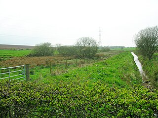
What now survives of the old Caprington Loch (NS402352) is situated near Earlston, Riccarton, East Ayrshire, Scotland. The loch was a natural feature, sitting in a hollow on the old Caprington Castle estate. The loch waters drain via the Todrigs Burn that flows into the River Irvine to the east of Gatehead village. It was partly drained, probably sometime after the 1820s, as were so many other lochs, as part of 18th and 19th centuries extensive agricultural improvements and the only area of open water that remains does so as it was once used as a curling pond for the Caprington Castle Estate owners and their employees or tenants.

<span class="mw-page-title-main">Craigie, South Ayrshire</span> Human settlement in Scotland

Craigie is a small village and parish of 6,579 acres in the old district of Kyle, now South Ayrshire, four miles south of Kilmarnock, Scotland. This is mainly a farming district, lacking in woodland, with a low population density, and only one village. In the 19th century, high quality lime was quarried here with at least three sites in use in 1832.

References

Notes

  1. "John Thomson's Atlas of Scotland, 1832" . Retrieved 1 August 2018.
  2. "1854-1859 - ORDNANCE SURVEY - Six-inch 1st edition maps of Scotland" . Retrieved 1 August 2018.
  3. "Sir William Wallace - East Ayrshire Council" . Retrieved 1 August 2018.
  4. "Ordnance Survey Name Books, 1855-1857. Ayrshire Volume-53/19" . Retrieved 1 August 2018.
  5. 1 2 3 Archibald R. Adamson (1875). Rambles Round Kilmarnock. T. Stevenson, Kilmarnock. p. 49.
  6. Wilson, Professor & Chambers, Robert (1840) The Land of Burns. Pub. Blackie & Son. London. P. 75.
  7. "Dictionary of the Scots Language" . Retrieved 1 August 2018.
  8. James Paterson (1863). History of the Counties of Ayr and Wigton. V.1. Kyle. James Stillie. p. 641.
  9. Dane Love (1863). Legendary Ayrshire. Carn Publishing. p. 87.
  10. "British Hardwood Tree Nursery" . Retrieved 1 August 2018.
  11. "How Long Can Trees Live For?" . Retrieved 1 August 2018.
  12. Robert Chambers (1840). The Land of Burns. Blackie & Sons, London. p. 74.
  13. John Strawhorn (1951). The Third Statistical Account of Scotland. Ayrshire. Oliver & Boyd, Edinburgh. p. 456.
  14. John MacIntosh (1894). Ayrshire Nights' Entertainments. Dunlop & Dreenan, Kilmarnock. p. 90.
  15. Archibald R. Adamson (1875). Rambles Round Kilmarnock. T. Stevenson, Kilmarnock. p. 50.
  16. Archibald R. Adamson (1875). Rambles Round Kilmarnock. T. Stevenson, Kilmarnock. pp. 49–50.
  17. Love, Dane (2009). Legendary Ayrshire. Custom : Folklore : Tradition. Auchinleck : Carn Publishing. ISBN   978-0-9518128-6-0. pp. 86 - 87
  18. John MacIntosh (1894). Ayrshire Nights' Entertainments. Dunlop & Dreenan, Kilmarnock. pp. 90–91.
  19. "Canmore - Kilmarnock Bickering Bush" . Retrieved 1 August 2018.
  20. "Clyde Coast Graphics" . Retrieved 1 August 2018.
Sources
  1. Boyle, Andrew M. (1996). The Ayrshire Book of Burns-Lore. Darvel : Alloway Publishing. ISBN   0-907526-71-3.
  2. Love, Dane (2000). Ayr Stories. Ayr : Fort Publishing. ISBN   0-9536576-1-2.
  3. Love, Dane (2009). Legendary Ayrshire. Auchinleck : Carn Publishing. ISBN   978-0-9518128-6-0.
  4. Love, Dane (2003). Ayrshire : Discovering a County. Ayr : Fort Publishing. ISBN   0-9544461-1-9.
  5. Paterson, James (1863–66). History of the Counties of Ayr and Wigton. V. - II - Kyle. J. Stillie. Edinburgh.

55°35′43″N4°30′41″W / 55.59528°N 4.51139°W / 55.59528; -4.51139