Bellsbank

Last updated

Bellsbank
Village
Bellsbank View - geograph.org.uk - 1096701.jpg
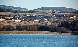
Bellsbank View Bellsbank viewed from the south side of Bogton Loch.
East Ayrshire UK location map.svg
Red pog.svg
Bellsbank
Location within East Ayrshire
Population1,260 (mid-2020 est.) [1]
OS grid reference NS480045
Council area
Country Scotland
Sovereign state United Kingdom
Postcode district KA6 7xx
Dialling code 01292 55
Police Scotland
Fire Scottish
Ambulance Scottish
UK Parliament
Scottish Parliament
List of places
UK
Scotland
55°18′42″N4°23′47″W / 55.311802°N 4.396416°W / 55.311802; -4.396416

Bellsbank is a village half a mile away from the market town of Dalmellington in East Ayrshire, Scotland. It is the second-highest place in East Ayrshire; only Muirkirk is higher than this. Bellsbank is now classed as a separate town from Dalmellington.

Contents

History

Bellsbank was originally established to provide housing for the population of Benquhat (one of several "ghost" villages in the Doon Valley that have been demolished).

Expanded between the wars to house miners from worked out areas that were relocated there. Laid out by the County Council the houses looked out over Bogton Loch, Craigengillan Estate and the Loch Doon Hills.

Educational provision

Bellsbank welcomed a new primary school in February 2020, to replace the old school opened in 1955. The new school was built in the grounds of the old school and opened to pupils on the 9th of February 2020. The current head teacher is Donald Currie.

Awards and accolades

Bellsbank was the winner of the Scottish Civic Trust - My Place Award thanks to the partnership between East Ayrshire Council and community group CANI in the Community. Bellsbank has also gained media attention due to a scheme by East Ayrshire Council in partnership with CANI in the Community and the local Primary School in which houses were rendered in pastel colours to improve the look of the village following years of decline.

Related Research Articles

<span class="mw-page-title-main">Aberfoyle, Stirling</span> Human settlement in Scotland

Aberfoyle is a village in the historic county and registration county of Perthshire and the council area of Stirling, Scotland. The settlement lies 27 miles northwest of Glasgow.

<span class="mw-page-title-main">East Ayrshire</span> Council area of Scotland

East Ayrshire is one of 32 unitary council areas of Scotland. It shares borders with Dumfries and Galloway, East Renfrewshire, North Ayrshire, South Ayrshire and South Lanarkshire. The headquarters of the council are located on London Road, Kilmarnock. With South Ayrshire and the mainland areas of North Ayrshire, it formed the former county of Ayrshire.

<span class="mw-page-title-main">Inverclyde</span> Council area of Scotland

Inverclyde is one of 32 council areas used for local government in Scotland. Together with the East Renfrewshire and Renfrewshire council areas, Inverclyde forms part of the historic county of Renfrewshire, which currently exists as a registration county and lieutenancy area. Inverclyde is located in the west central Lowlands. It borders the North Ayrshire and Renfrewshire council areas, and is otherwise surrounded by the Firth of Clyde.

<span class="mw-page-title-main">Ayr</span> Administrative centre and town in Scotland

Ayr is a town situated on the southwest coast of Scotland. A former Royal Burgh, today it is the administrative centre of the South Ayrshire Council, and the historic county town of Ayrshire. With a population of 46,982, Ayr is the 15th largest settlement in Scotland and second largest town in Ayrshire by population. The town is contiguous with the smaller town of Prestwick to the north.

<span class="mw-page-title-main">Kilmarnock</span> Burgh in East Ayrshire, Scotland

Kilmarnock is a large town and former burgh in East Ayrshire, Scotland and is the administrative centre of East Ayrshire Council. With a population of 46,770, Kilmarnock is the 14th most populated settlement in Scotland and the largest town in Ayrshire by population. The town is continuous to nearby neighbouring villages Crookedholm and Hurlford to the east, and Kilmaurs to the west of the town. It includes former villages subsumed by the expansion of the town such as Bonnyton and new purpose built suburbs such as New Farm Loch. The town and the surrounding Greater Kilmarnock area is home to 32 listed buildings and structures designated by Historic Environment Scotland.

<span class="mw-page-title-main">Cumnock</span> Town and former civil parish in Scotland

Cumnock is a town and former civil parish located in East Ayrshire, Scotland. The town sits at the confluence of the Glaisnock Water and the Lugar Water. There are three neighbouring housing projects which lie just outside the town boundaries, Craigens, Logan and Netherthird, with the former ironworks settlement of Lugar also just outside the town, contributing to a population of around 13,000 in the immediate locale. A new housing development, Knockroon, was granted planning permission on 9 December 2009 by East Ayrshire Council.

<span class="mw-page-title-main">Kyle and Carrick</span>

<span class="mw-page-title-main">Ayr, Carrick and Cumnock (UK Parliament constituency)</span> Parliamentary constituency in the United Kingdom, 2005 onwards

Ayr, Carrick, and Cumnock is a county constituency represented in the House of Commons of the Parliament of the United Kingdom. It was created for the 2005 general election from parts of the old Ayr and Carrick, Cumnock and Doon Valley constituencies. It has been represented since 2019 by Allan Dorans of the Scottish National Party.

<span class="mw-page-title-main">Kilbirnie</span> Town in North Ayrshire, Scotland

Kilbirnie is a small town of 7,280 inhabitants situated in the Garnock Valley area of North Ayrshire, on the west coast of Scotland. It is around 20 miles (30 km) southwest of Glasgow and approximately 10 miles from Paisley and 13 miles from Irvine respectively. Historically, the town's main industries were flax production and weaving before iron and steelmaking took over in the 19th and early 20th centuries. The suburb of Kilbirnie in the New Zealand capital of Wellington is named after the town.

<span class="mw-page-title-main">Patna, East Ayrshire</span> Human settlement in Scotland

Patna is a village in East Ayrshire, Scotland, straddling the traditional districts of Carrick and Kyle.

<span class="mw-page-title-main">River Doon</span>

The River Doon is a river in Ayrshire, Scotland. Its course is generally north-westerly, passing near to the town of Dalmellington, and through the villages of Patna, Dalrymple, and Alloway, birthplace of Robert Burns. The source of the Doon is Loch Doon, high in the Galloway Hills.

<span class="mw-page-title-main">Ochiltree</span> Human settlement in Scotland

Ochiltree is a conservation village in East Ayrshire, Scotland, near Auchinleck and Cumnock. It is one of the oldest villages in East Ayrshire, with archaeological remains indicating Stone Age and Bronze Age settlers. A cinerary urn was found in 1955 during excavation for a new housing estate.

<span class="mw-page-title-main">Carrick, Cumnock and Doon Valley (Scottish Parliament constituency)</span> Region or constituency of the Scottish Parliament

Carrick, Cumnock and Doon Valley is a county constituency of the Scottish Parliament at Holyrood, covering parts of the council areas of South Ayrshire and East Ayrshire. It elects one Member of the Scottish Parliament (MSP) by the plurality method of election. Also, it is one of nine constituencies in the South Scotland electoral region, which elects seven additional members, in addition to the nine constituency MSPs, to produce a form of proportional representation for the region as a whole.

<span class="mw-page-title-main">Dalmellington</span> Market town and civil parish in Scotland

Dalmellington is a market town and civil parish in East Ayrshire, Scotland. In 2001 the village had a population of 1,407. The town owes its origins to the fault line separating the Southern Uplands of Scotland from the Central Lowlands. Dalmellington sits at the issue of a river from the uplands into Dalmellington Moss plain.

<span class="mw-page-title-main">Carsphairn and Scaur Hills</span>

The Carsphairn and Scaur Hills are the western and eastern hills respectively of a hill range in the Southern Uplands of Scotland. Ordnance Survey maps don't have a general name for the hill area as a whole. Also, Ordnance Survey use "Scar" rather than the local spelling of "Scaur" - the word is pronounced as "Scar" however. In their Landranger Series of maps, it requires four separate sheets to cover the area.

<span class="mw-page-title-main">Dalmellington railway station</span> Disused railway station in Dalmellington, East Ayrshire

Dalmellington railway station served the town of Dalmellington, East Ayrshire, Scotland, from 1856 to 1964 on the Ayr and Dalmellington Railway.

Dalrymple is a village and parish in East Ayrshire, Scotland, lying in the Doon Valley on the north bank of the River Doon. The population is around 1,347.

<span class="mw-page-title-main">Doon Valley (ward)</span>

Doon Valley is one of the nine electoral wards of East Ayrshire Council. Created in 2007, the ward elects three councillors using the single transferable vote electoral system and covers an area with a population of 11,592 people.

Dalmellington was one of 32 electoral wards of East Ayrshire Council. Originally created in 1974, the ward was initially within Cumnock and Doon Valley District Council before the local government reforms in the 1990s. The ward elected one councillor using the first-past-the-post voting electoral system.

References

  1. "Mid-2020 Population Estimates for Settlements and Localities in Scotland". National Records of Scotland. 31 March 2022. Retrieved 31 March 2022.

[1]


  1. "East Ayrshire mining village paints its way out of deprivation". HeraldScotland. Retrieved 9 February 2021.