
Perthshire, officially the County of Perth, is a historic county and registration county in central Scotland. Geographically it extends from Strathmore in the east, to the Pass of Drumochter in the north, Rannoch Moor and Ben Lui in the west, and Aberfoyle in the south; it borders the counties of Inverness-shire and Aberdeenshire to the north, Angus to the east, Fife, Kinross-shire, Clackmannanshire, Stirlingshire and Dunbartonshire to the south and Argyllshire to the west. It was a local government county from 1890 to 1930.

Perth and Kinross is one of the 32 council areas of Scotland and a Lieutenancy Area. It borders onto the Aberdeenshire, Angus, Argyll and Bute, Clackmannanshire, Dundee, Fife, Highland and Stirling council areas. Perth is the administrative centre. With the exception of a large area of south-western Perthshire, the council area mostly corresponds to the historic counties of Perthshire and Kinross-shire.

Rannoch Moor is an expanse of around 50 square miles (130 km2) of boggy moorland to the west of Loch Rannoch in Scotland, where it extends from and into westerly Perth and Kinross, northerly Lochaber, and the area of Highland Scotland toward its south-west, northern Argyll and Bute. Rannoch Moor is designated a Site of Special Scientific Interest (SSSI) and a Special Area of Conservation. Much of the western part of the moor lies within the Ben Nevis and Glen Coe National Scenic Area, one of 40 such areas in Scotland.

Loch Rannoch is a freshwater loch in Perth and Kinross, Scotland. It is over 15 kilometres (9.3 mi) long in a west–east direction with an average width of about 1.2 kilometres (0.75 mi), and is deepest at its eastern end, reaching a depth of 130 metres (440 ft). The River Tummel begins at its eastern end, where the small village of Kinloch Rannoch can be found, whilst the wild expanse of Rannoch Moor extends to the west of the loch. The area surrounding Loch Rannoch, along with Rannoch Moor itself, was formerly part of the native Caledonian Forest that stretched across much of Northern Scotland. Native forest is now largely absent from much of the area, due partly to logging, and partly to the climate becoming wetter, and Loch Rannoch is now largely surrounded by commercial forestry and open hillsides, although a small area remains at the Black Wood of Rannoch on the southern shore of the loch.

Rannoch is an area of the Scottish Highlands between the A9 road, to the east, and the A82, to the west. The area is crossed from south to north by the West Highland railway line.

Corrour railway station Scottish Gaelic: Coire Odhar, dun-coloured corrie, is on the Crianlarich-Fort William/Mallaig branch of the West Highland Line. It is situated near Loch Ossian on the Corrour Estate, Highland Region, Scotland. It is the highest mainline railway station in the United Kingdom.

Loch Tummel is a long, narrow loch, 7 km (4.3 mi) north west of Pitlochry in the council area of Perth and Kinross, Scotland. It is fed and drained by the River Tummel, which flows into the River Tay about 13 km (8.1 mi) south-east of the Clunie Dam at the loch's eastern end.

Rannoch railway station, on the West Highland Line, serves the area of Rannoch in Perth and Kinross, Scotland. Its remote location on Rannoch Moor is picturesque and makes it attractive to walkers. The station has a tea room and visitor centre. In 2017, Simon Jenkins reported it to be one of the best 100 stations in Britain.

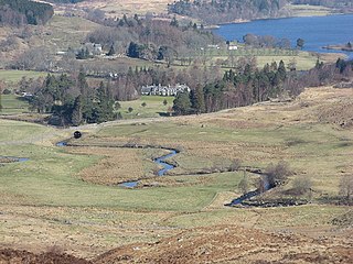
Kinloch Rannoch is a village in Perth and Kinross, Scotland, at the eastern end of Loch Rannoch, 18 miles (29 km) west of Pitlochry, on the banks of the River Tummel. The village is a tourist and outdoor pursuits centre. It has a small population and is fairly remote.

Loch Ossian is a narrow loch that is about 5 kilometres (3.1 mi) long on the north eastern edge of Rannoch Moor, on The Corrour Estate, with its western corner 2 kilometres (1.2 mi) east of Corrour railway station. It is drained by the River Ossian, flowing north into Loch Guilbinn and ultimately to the River Spean at Moy.
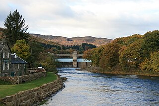
The Tummel hydro-electric power scheme is an interconnected network of dams, power stations, aqueducts and electric power transmission in the Grampian Mountains of Scotland. Roughly bounded by Dalwhinnie in the north, Rannoch Moor in the west and Pitlochry in the east it comprises a water catchment area of around 1,800 square kilometres (690 sq mi) and primary water storage at Loch Ericht, Loch Errochty, Loch Rannoch and Loch Tummel, in Perth and Kinross. Water, depending on where it originates and the path it takes, may pass through as many as five of the schemes nine power stations as it progresses from north-west to south-east. The scheme was constructed in the 1940s and 50s incorporating some earlier sites. It is currently managed by SSE plc.

Dunalastair Water is an entirely man made reservoir in Scotland which lies between Loch Rannoch and Loch Tummel in Strath Tummel in Perth and Kinross council area. The loch provides water power for the Tummel hydroelectricity power station and has the reputation as one of the best wild trout fishing locations in the United Kingdom.

Beinn a’ Chuallaich is a Scottish hill, four kilometres northeast of the village of Kinloch Rannoch in the Perth and Kinross council area. It is part of the high ground between Strath Tummel and Glen Errochty.
Rannoch Barracks was a military barracks constructed in 1746 at Bridge of Gaur, Perthshire, Scotland, at the western end of Loch Rannoch. The barracks were built in response to the Jacobite uprising of 1745.

Braes of Rannoch is a hill with a deserted hamlet and church in Perthshire. The hamlet was formerly, briefly, called Georgetown, as the redcoat barracks of Jacobite rising of 1745 were then known, then known as Bridge of Rannoch, or Bridge of Gaur, after the bridge on the River Gaur. The original barracks have gone but a large house and shooting lodge, Rannoch Barracks, is named after them. The Braes of Rannoch Manse became a hostel for forestry workers by the 1970s. The church is today a tourist feature on the road from Kinloch Rannoch to Rannoch Station.

Ben Nevis and Glen Coe is a national scenic area (NSA) covering part of the Highlands of Scotland surrounding Ben Nevis and Glen Coe, in which certain forms of development are restricted. It is one of 40 such areas in Scotland, which are defined so as to identify areas of exceptional scenery and to ensure its protection from inappropriate development. The Ben Nevis and Glen Coe NSA covers 903 km2 (349 sq mi) of land, lying within the Highland, Argyll and Bute and Perth and Kinross council areas. A further 19 km2 (7.3 sq mi) of the NSA are marine, covering the sea loch of Loch Leven.

Loch Eigheach is a large upland dammed freshwater loch in the Scottish Highlands. It is located in Rannoch Moor in the Council Area of Perth and Kinross. The undisturbed Loch Eigheach was much smaller.

Sgor Gaibhre is a mountain in the Grampian Mountains of Scotland. It lies on the border of Highland and Perth and Kinross, near Loch Ossian.

Carn Dearg is a remote mountain in the Grampian Mountains of Scotland. It lies east of Rannoch Moor, on the border of Highland and Perthshire.


