Bieleboh

Last updated
Bieleboh
Fotothek df rp-b 0040049 Beiersdorf. Blick von der Hadermuhle auf den Bieleboh.jpg
Bieleboh seen from Hadermühle (1977)
Highest point
Elevation 499.5 m (1,639 ft) [1]
DE-HN
Coordinates 51°4′51″N14°31′17″E / 51.08083°N 14.52139°E / 51.08083; 14.52139 Coordinates: 51°4′51″N14°31′17″E / 51.08083°N 14.52139°E / 51.08083; 14.52139
Geography
Saxony relief location map.jpg
Red triangle with thick white border.svg
Bieleboh
Bieleboh in Saxony
Location Beiersdorf, Saxony, Germany
Parent range Lusatian Highlands

Bieleboh is a mountain in the Lusatian Highlands, in the east of Saxony, Germany. Its summit is located on the grounds of Beiersdorf municipality.

Contents

Geography and geology

Bieleboh is located between the villages of Beiersdorf and Cunewalde, on the border of districts Bautzen and Görlitz which passes about 60 m north of its summit. The mountain consists chiefly of granite and granodiorite. An observation tower and a mountain restaurant are located on its summit.

Name

The name shows an analogy to that of the neighbouring mountain Czorneboh. As the latter refers to the deity Čorny Bóh (Upper Sorbian for "black god"), Bieleboh may be considered to be named after a "white god" Běły Boh. However, the latter is not explicitly mentioned in historic sources, but can possibly be identified with Svetovid. The authenticity of the Sorbian names is disputed, as they have only been recorded in the early modern period. In 1746, Bieleboh was still called Hoher Wald, and only on maps printed between 1780 and 1806 it was first named as Pilobogg or Beyersdorferberg, together with Zschernebog (Czorneboh). [2] Another name, Kaspers Berg, which referred to the owner of the forest, a landowner and waggoner in Beiersdorf, has fallen out of use. In the course of the Germanisation of Slavic geographical names, the mountain was renamed Huhberg in 1936, but was named back in 1945.

History

Mountain restaurant with observation tower (2004) Bieleboh.jpg
Mountain restaurant with observation tower (2004)

In 1841, Karl Benjamin Preusker (1786–1871), a librarian and archaeologist from Löbau, made drawings of a legendary rock formation on the summit which he called "the altar of Bielybog". [3]

The inn keeper of Beiersdorf started to hold marksmens' fairs on the mountain after 1830.

The mountain club Oberes Spreetal ("Upper Spree valley") was founded in 1882 and began to build an observation platform near the existing obelisk, but abandoned this project in favour of a 12 m tall observation tower which was opened on 6 May 1883. This tower was destroyed by a lightning strike on 2 July 1910 and burned down completely. The Bieleboh club collected donations from the population, and Landesverein Sächsischer Heimatschutz (the national club for the preservation of the Saxon homeland) had a design drawn up for a new tower which was to be 4 m higher than the old one and received a roof. The new tower was already completed on 25 September 1910 and was ceremoniously opened. In 1994 it had fallen out of repair and had to be closed. It was renovated in 1998, and its height was increased by a further 5 m, reaching 21 m altogether in order to provide a better view across the tree tops. [4]

Solar observations

Sun shining through the opening in "Bieleboh altar" on an equinox Bielebohaltar mit Sonnendurchgang Tagundnachtgleiche Sonnenaufgang 2008.jpg
Sun shining through the opening in "Bieleboh altar" on an equinox

According to Karl Benjamin Preusker, several rocks in Upper Lusatia were considered prehistoric offering altars. Among these he counted a rock on Bieleboh, the so-called "Bieleboh altar". [3] [5] Local historians from Sohland an der Spree examined this presumed altar for its possible calendarial use for observations of the sun in 2007. It could be shown that an eye-shaped opening through the rock, the Teufelsauge ("devil's eye"), allows to determine the day of the equinox when the light of the rising sun passes through it. [6] [7]

Tourism

The observation tower offers views across the Lusatian Highlands and the volcanic chain of the Lusatian Mountains. Notable mountains in view are Czorneboh, Kottmar, Löbauer Berg, and Oberoderwitzer Spitzberg. On clear days, the Jizera Mountains and Krkonoše in the south east as well as the Eastern Ore Mountains in the west can be seen. [4]

A road leads from Beiersdorf to the summit. A parking lot for hikers is located 400 m ahead of the summit, on the saddle between Bieleboh and neighbouring Kuhberg. The long distance trail between Zittau and Wernigerode, marked with a blue stripe on a white background and known here as Oberlausitzer Bergweg (Upper Lusatian Mountain Trail), passes across the mountain. Several other hiking paths offer routes onto the mountain.

Further reading

Related Research Articles

Lusatia Historical region

Lusatia is a historical region in Central Europe, split between Germany and Poland. Lusatia stretches from the Bóbr and Kwisa rivers in the east to the Pulsnitz and Black Elster rivers in the west, and is located within the German states of Saxony and Brandenburg as well as in the Polish voivodeships of Lower Silesia and Lubusz. Lusatia's central rivers are the Spree and the Lusatian Neisse, which constitutes the border between Germany and Poland since 1945. The Lusatian Mountains, separate Lusatia from Bohemia in the south. Lusatia is traditionally divided into Upper Lusatia and Lower Lusatia.

The district of Bautzen is a district in the state of Saxony in Germany. Its largest towns are Bautzen, Bischofswerda, Kamenz, Hoyerswerda and Radeberg. It is the biggest district in Saxony by area, and a member of the Neisse Euroregion.

Bischofswerda Town in Saxony, Germany

Bischofswerda is a small town in Germany at the western edge of Upper Lusatia in Saxony.

Löbau Town in Saxony, Germany

Löbau is a city in the east of Saxony, Germany, in the traditional region of Upper Lusatia. It is situated between the slopes of the Löbauer Berg and the fertile hilly area of the Upper Lusatian Mountains. It is the gateway to this volcanic mountainous area and is situated halfway between the cities of Bautzen, Görlitz and Zittau.

Wehrsdorf

Wehrsdorf is a small village in a valley of the Lusatian Highlands in the region of Upper Lusatia (Oberlausitz) in Saxony, Germany. It has about 1,776 inhabitants and belongs to an administrative community of three different villages, with Sohland an der Spree and Taubenheim. This community is offícially called Sohland after the largest of these villages. Altogether, the community has about 7,700 inhabitants. The village is near the border to the Czech Republic.

Bad Muskau Town in Saxony, Germany

Bad Muskau is a spa town in the historic Upper Lusatia region in Germany, at the border with Poland. It is part of the Görlitz district in the State of Saxony.

Upper Lusatia

Upper Lusatia is a historical region in Germany and Poland. Along with Lower Lusatia to the north, it makes up the region of Lusatia, named after the Slavic Lusici tribe. Both Lusatias are home to the West Slavic minority group of the Sorbs.

Lusatian Highlands

The Lusatian Highlands or Lusatian Hills form a hilly region in Germany and the Czech Republic. A western extension of the Sudetes range, it is located on the border of the German state of Saxony with the Czech Bohemian region. It is one of the eight natural landscapes of Upper Lusatia.

Cunewalde Municipality in Saxony, Germany

Cunewalde or in the Sorbian language Kumwałd is a municipality in the district of Bautzen in the east of the federal Free State of Saxony in Germany. It lies between the cities of Bautzen and Löbau in a valley between the hills of the Czorneboh, the Hochstein and the Bieleboh, all part of the northernmost mountain ranges of the Lusatian Highlands. It is one of the more populous villages in Upper Lusatia and the longest street village in all of Germany.

Wesenitz River in Germany

The Wesenitz is a river in Saxony, Germany, right tributary of the Elbe. Its total length is 83 km (52 mi). The Wesenitz runs through the tourist regions of the Lusatian Highlands and Saxon Switzerland. Its name is derived from Sorbian language wjaz (Elm).

Czorneboh

Czorneboh is a mountain between Hochkirch and Cunewalde in Upper Lusatia. Czorneboh is located 10 km. from the German-Czech border north of Šluknov and 8 km. southeast of Bautzen and with an altitude of 555.7 m it is the highest point of this foothill of the Lusatian Highlands. The peak of the Czorneboh is located in the district of Meschwitz. On the top there is a mountain hostel and an observation tower.

Hochstein (Lawalde)

The Hochstein is a mountain in Saxony, eastern Germany. At an elevation of 533.1 m (1,749 ft), it is the easternmost peak of the Czorneboh chain in the Upper Lusatian Highlands.

Werte der deutschen Heimat

Werte der deutschen Heimat originally Werte der Deutschen Heimat and, between 1970 and 1990 called Werte unserer Heimat, was a series of publications by former East German Academy of Sciences at Berlin, that was published by Akademie-Verlag Berlin and included more than 50 volumes. The work was undertaken by the Academy’s Local History Working Group within the Institute for Geography and Geo-ecology.

Upper Lusatian house

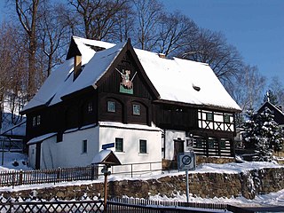
The Upper Lusatian house or Umgebindehaus is a special type of house that combines log house, timber-framing and building stone methods of construction. It is especially common in the region running from Silesia through Upper Lusatia and North Bohemia and into Saxon Switzerland, as well as East Thuringia.

Sonneberg (hill)

The Sonneberg, also called the Buchberg, is a hill in the Lusatian Highlands of eastern Germany with a height of 401.0 m above sea level (NN). It is the fourth highest hill in the borough of Neusalza-Spremberg in Saxony, after the Fuchsberg and Hahneberg and an unnamed peak about 600 metres north of the Sonneberg.

Kottmar (municipality) Municipality in Saxony, Germany

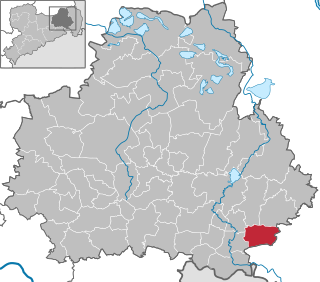
Kottmar is a municipality in the district of Görlitz, in Saxony, Germany, created with effect from 1 January 2013 by the merger of the municipalities of Eibau, Niedercunnersdorf and Obercunnersdorf. Its name derives from the Kottmar mountain.

Eastern Upper Lusatia

Eastern Upper Lusatia is a natural region in Saxony and, in a broader sense, part of the Western Sudetes range including the Lower Silesian Voivodeship. The current Saxon division of natural regions view the region as part of the Saxon Loess Fields and divides it into 12 subdivisions at the level of meso-geochores.

Natural regions of Saxony

The classification of natural regions of Saxony shown here was produced between 1994 and 2001 by a working group called "Ecosystem and Regional Character" at the Saxonian Academy of Sciences in Leipzig as part of the research and development project "Natural Regions and Natural Region Potential of the Free State of Saxony" at a scale of 1:50,000 as the basis for the rural development and regional planning. This was also supported by the Saxon State Ministry of the Environment and Agriculture and the Saxon Ministry of the Interior.

Alfred Moschkau

Otto Carl Alfred Moschkau (1848-1912) was a German philatelist and local historian. In 2021 he was retrospectively named as one of the fathers of philately.

References

  1. "Karte der Schutzgebiete". Bundesamt für Naturschutz. Archived from the original on 2017-07-06. Retrieved 2016-07-11.
  2. Meilenblätter von Sachsen. "Berliner Exemplar" (1804), Sheet 347; "Geographische Meridianbestimmung Sächsischer Orte". Staatswissenschaft im Lichte unserer Zeit. Leipzig (115): 917. 1827.
  3. 1 2 Karl Benjamin Preusker (1841). Blicke in die Vaterländische Vorzeit. p.  189 and plate I, No. 6.
  4. 1 2 "Aussichtsturm". Bergwirtschaft Bieleboh. Archived from the original on 2016-06-27. Retrieved 2016-07-11.
  5. Karl Benjamin Preusker (1828). Ober-Lausitzische Altertümer. Gesellschaft der Wissenschaft zu Görlitz. pp. 35–51.
  6. Infopack 2011, "Sonnenheiligtümer der Oberlausitz", Sternwarte „Bruno-H.-Bürgel“ Sohland/Spree
  7. Ralf Herold (2012). Sonnenheiligtümer der Oberlausitz – Der Geldkeller auf dem Löbauer Berg und sein wahrer Schatz. Oberlausitzer Verlag.