Lusatia is a historical region in Central Europe, territorially split between Germany and modern-day Poland. Lusatia stretches from the Bóbr and Kwisa rivers in the east to the Pulsnitz and Black Elster rivers in the west, and is located within the German states of Saxony and Brandenburg as well as in the Polish voivodeships of Lower Silesia and Lubusz. Major rivers of Lusatia are the Spree and the Lusatian Neisse, which defines the border between Germany and Poland. The Lusatian Mountains of the Western Sudetes separate Lusatia from Bohemia in the south. Lusatia is traditionally divided into Upper Lusatia, the hilly southern part, and Lower Lusatia, the flat northern part.
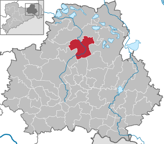
The district of Bautzen is a district in the state of Saxony in Germany. Its largest towns are Bautzen, Bischofswerda, Kamenz, Hoyerswerda and Radeberg. It is the biggest district in Saxony by area, and a member of the Neisse Euroregion.
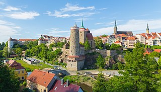
Bautzen or Budyšin, until 1868 Budissin in German, is a town in eastern Saxony, Germany, and the administrative centre of the district of Bautzen. It is located on the Spree river, is the eighth most populous town in Saxony, and is the seat of Saxony's largest district. Bautzen lies in the bilingual Sorbian settlement area of Lusatia, and is Lusatia's third-largest town after Cottbus and Görlitz, as well as the second-largest town in Upper Lusatia.

Herrnhut is an Upper Lusatian town in the Görlitz district in Saxony, Germany, known for the community of the Moravian Church established by Nicolas Ludwig, Count von Zinzendorf, in 1722. In 2024, the town was inscribed on World Heritage List as a part of the serial site of Moravian Church Settlements.

Kamenz or Kamjenc is a town in the district of Bautzen in Saxony, Germany. Until 2008 it was the administrative seat of Kamenz District. The town is known as the birthplace of the philosopher and poet Gotthold Ephraim Lessing and Bruno Hauptmann, convicted kidnapper of the Lindbergh baby. It lies north-east of the major city of Dresden.

Löbau is a city in the east of Saxony, Germany, in the traditional region of Upper Lusatia. It is situated between the slopes of the Löbauer Berg and the fertile hilly area of the Upper Lusatian Mountains. It is the gateway to this volcanic mountainous area and is situated halfway between the cities of Bautzen, Görlitz and Zittau.

Upper Lusatia is a historical region in Germany and Poland. Along with Lower Lusatia to the north, it makes up the region of Lusatia, named after the Slavic Lusici tribe. Both parts of Lusatia are home to the West Slavic minority group of the Sorbs.

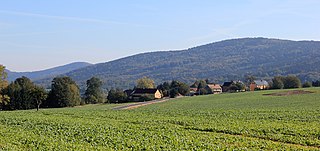
Hochkirch (German) or Bukecy is a municipality in the district of Bautzen, in Saxony, Germany. It is known for the 1758 Battle of Hochkirch, part of the Seven Years' War.
The Lusatian League was a historical alliance of six towns in the region of Upper Lusatia from 1346 until 1815, when the region was controlled first by Bohemia (1346–1635) and later by the Electorate of Saxony (1635–1815). The member towns were Bautzen, Görlitz, Kamenz, Lauban, Löbau and Zittau. Five of the towns are located in present-day Germany; Lubań and Zgorzelec are within Poland.

Schirgiswalde is a town and a former municipality in the district of Bautzen in Saxony in Germany. Since 1 January 2011, it is part of the town Schirgiswalde-Kirschau. It is located on the river Spree, 15 km south of Bautzen. The small town is an official place of relaxation. Schirgiswalde is an Ortschaft of the town Schirgiswalde-Kirschau. It consists of the Ortsteile Schirgiswalde and Neuschirgiswalde.
Weißenberg (German) or Wóspork is a town in the district of Bautzen, in Saxony, Germany. The Upper Lusatian town has approximately 3100 inhabitants and is part of the recognized Sorbian settlement area in Saxony.
Wittichenau (German) or Kulow is a bilingual town in the district of Bautzen in the Free State of Saxony, Germany. It is situated on the river Schwarze Elster, 6 km south of Hoyerswerda.

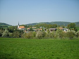
Neukirch/Lausitz (German) or Wjazońca is a municipality in Upper Lusatia in the district of Bautzen, in the state of Saxony in eastern Germany. It belongs to the district of Bautzen and is situated in several valleys of the mountain region Lausitzer Bergland, near the hill "Valtenberg" that reaches about 587 metres. It has about 5,066 inhabitants in an area of 21.32 km², a population density of 240 per km². The German name Lausitz means Lusatia.

Frankenthal is a municipality in eastern Saxony, Germany. It belongs to the district of Bautzen and lies west of the eponymous city. It is named after Frankish colonists who settled in Lusatia ca. 1200.

Malschwitz (German) or Malešecy is a municipality in the east of Saxony, Germany. It belongs to the district of Bautzen and lies 6 km northeast of the eponymous city.

Räckelwitz (German) or Worklecy is a municipality in Bautzen district, in the state of Saxony, Germany. The municipality of Räckelwitz has a population of 1,111 (2020) and is a member of the municipal association "Am Klosterwasser"(Zarjadniski zwjazk „Při Klóšterskej wodźe“).
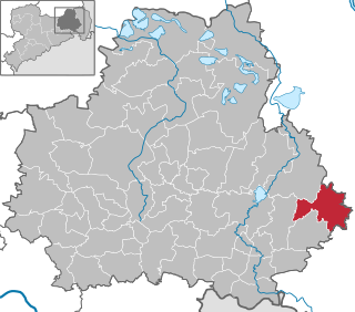
Görlitz district is a district (Kreis) in Saxony, and the easternmost in Germany. It is named after its capital Görlitz. It borders the district of Bautzen, the state of Brandenburg, Poland and the Czech Republic.

Bieleboh is a mountain in the Lusatian Highlands, in the east of Saxony, Germany. Its summit is located on the grounds of Beiersdorf municipality.
Czorneboh is a mountain between Hochkirch and Cunewalde in Upper Lusatia. Czorneboh is located 10 km. from the German-Czech border north of Šluknov and 8 km. southeast of Bautzen and with an altitude of 555.7 m it is the highest point of this foothill of the Lusatian Highlands. The peak of the Czorneboh is located in the district of Meschwitz. On the top there is a mountain hostel and an observation tower.
The 2008 Saxony district reform came into force on 1 August 2008. The most important element of the reform was the further amalgamating, annexing, and merging of the districts created in the course of the 1994-1996 Saxony district reform, including the smaller independent cities.For a transitional period of five months, the formerly independent cities of Görlitz, Hoyerswerda, Zwickau and Plauen continued to perform district tasks, so that the district reform was practically only completed on 1 January 2009 when the new districts took over these tasks.