Ohorn

Last updated
Ohorn
Wappen ohorn.png
Location of Ohorn within Bautzen district
Ohorn in BZ.svg
Germany adm location map.svg
Red pog.svg
Ohorn
Saxony location map.svg
Red pog.svg
Ohorn
Coordinates: 51°10′30″N14°3′2″E / 51.17500°N 14.05056°E / 51.17500; 14.05056 Coordinates: 51°10′30″N14°3′2″E / 51.17500°N 14.05056°E / 51.17500; 14.05056
Country Germany
State Saxony
District Bautzen
Municipal assoc. Pulsnitz
Subdivisions5
Government
   Mayor (202027) Sonja Kunze [1]
Area
  Total12.07 km2 (4.66 sq mi)
Elevation
366 m (1,201 ft)
Population
 (2020-12-31) [2]
  Total2,445
  Density200/km2 (520/sq mi)
Time zone UTC+01:00 (CET)
  Summer (DST) UTC+02:00 (CEST)
Postal codes
01896
Dialling codes 035955
Vehicle registration BZ, BIW, HY, KM
Website www.ohorn-sachsen.de

Ohorn is a municipality in the district of Bautzen, in Saxony, Germany. Ohorn is a governmentally accredited recreation locality.

Contents

Geography and infrastructure

The municipality is located 2 km east of Pulsnitz and 30 km to the northeast of Dresden, the capital of Saxony. Embedded in the valley of the River Pulsnitz, Ohorn is surrounded by the typical landscape of the western Lusatian Hills, reaching a height of 449 m at the Hochstein Hill. Ohorn, having its own exit can be reached by using the A4 federal autobahn.

Local subdivision

Ohorn is divided into 5 parts: Fuchsbelle, Gickelsberg, Mitteldorf, Oberdorf and Röder.

Historical development

Following German Teutonic knights' call, in 1110 craftsmen, manufacturers and farmers from Thuringia, Franconia, Hesse and Bavaria came to settle in the area of the river Pulsnitz valley, creating a settlement of approximately 20 hectares (49 acres) on the southwestern side of the Schleißberg Hill, the river being an important factor in the location of the settlement.

Ohorn was first mentioned in historical documents in 1349 in the Book of Feuds owned by Frederick III, Landgrave of Thuringia, bearing the name "Ahorn", which stands for "Settlement by the maple tree/wood" [3] In 1537, Ohorn Manor was mentioned as an estate of the rule of Pulsnitz. Today, only parts of the country house, now giving space to a residential care home, and several buildings converted into housing establishments remain as well as the English style park. In those times, there were no important steps of development in Ohorn, its status as a farmer's settlement persisted because the state borders of the Diocese of Meißen and the Bohemian Kingdom took course through the settlement, exposing it to recurrent raids and warfare throughout the centuries. In addition, the number of inhabitants was decimated by epidemics; the plague resulted in the death of a fifth of the population.

In 1661, the ruling Knights of the Ohorn Manor approved the construction of a school building. The first school building to be recorded was established in 1750. Beginning in 1745, a drastic social change took place, since Michael Prescher introduced a ribbon weaving mill. Due to its development into an industrially shaped locality, Ohorn's demographics evolved accordingly: in 1885, there were 2000 people living in the settlement.

With increasing numbers of cottage weavers, better looms were required, leading to the establishment of the loom manufacturing business C.H. Schäfer, which now produces machine parts and is one of Ohorn's largest employers.

In 1827 and 1879, new school buildings were established. The first bus connection to the surrounding areas was established in 1912 by the smith Bernhard Mocke's postal stage bus, being the first one in Saxony, connecting the two cities of Pulsnitz and Königsbrück.

The Upper Guesthouse of Ohorn was reestablished as the city hall in 1925. Five years later, the former manor's steam mill was converted into the Betsaal, a hall. The Gymnastics Club of Ohorn has existed since 1865. The same year, a choir was established, but no longer exists. Thirty years later, the Compulsory Fire Brigade was converted into an auxiliary fire brigade.

In 1939, Ohorn was connected to the planned freeway between Dresden and Wrocław, which is the reason for its connection to the federal freeway 4.

Landmarks and places of interest

Economy

In Ohorn, two active farmers and a farmer's cooperative can be found today. There is only a limited number of weaving mills left.

Related Research Articles

Meissen is a district (Kreis) in the Free State of Saxony, Germany. It is bounded by the state of Brandenburg, the district of Bautzen, the urban district Dresden, the districts Sächsische Schweiz-Osterzgebirge, Mittelsachsen and Nordsachsen.

Böhlen Town in Saxony, Germany

Böhlen is a town in the Free State of Saxony, Germany, south of Leipzig. Its main features are a small airport and a power-plant. It is located in the newly built Neuseenland, the lakes created in the former open-pit mining areas.

Bad Gottleuba-Berggießhübel Town in Saxony, Germany

Bad Gottleuba-Berggießhübel is a spa town in the district Sächsische Schweiz-Osterzgebirge in the Free State of Saxony, Germany. The municipality borders the Czech Republic in the south. The municipality was formed on 1 January 1999 by the merger of the former municipalities Bad Gottleuba, Berggießhübel, Langenhennersdorf and Bahratal. Surrounded by forests and near a water dam Bad Gottleuba-Berggießhübel has several facilities, including a spa health park, a plant garden and a heated open air pool.

<span class="mw-page-title-main">Bad Schandau</span> Town in Saxony, Germany

Bad Schandau is a spa town in Germany, in the Sächsische Schweiz-Osterzgebirge district of the Free State of Saxony. It is situated on the right bank of the Elbe, at the mouth of the valley of the Kirnitzsch and in the area often described as Saxon Switzerland.

Mittweida Town in Saxony, Germany

Mittweida is a town in the Free State of Saxony, Germany, in the Mittelsachsen district.

Großenhain Town in Saxony, Germany

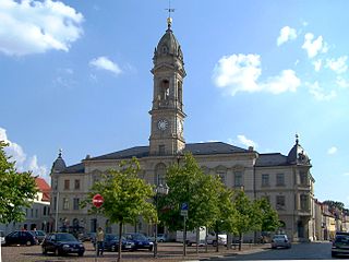
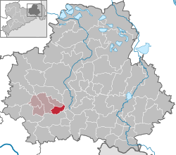
Großenhain is a Große Kreisstadt in the district of Meissen, Saxony, Germany. It was originally known as Hayne. The current name simply means "big Hayne"

Königstein, Saxony Town in Saxony, Germany

Königstein is a town on the Elbe river in the Free State of Saxony in Germany. Königstein lies in the Sächsische Schweiz-Osterzgebirge District and had a population of 2,089 in 2018. It includes land on both banks of the Elbe, but the centre and most of the town lies to the south of the river. The Königstein Fortress is situated above and to the south-west of the town.

Haselbachtal Municipality in Saxony, Germany

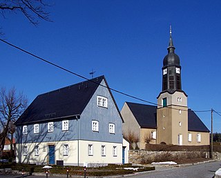
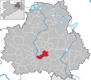
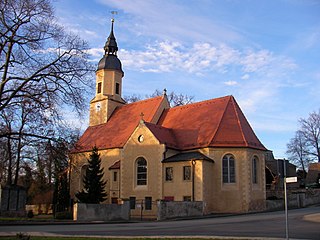
Haselbachtal is a municipality in the district of Bautzen in the Free State of Saxony, Germany with a population of 4,648. It consists of the villages Bischheim, Häslich, Gersdorf, Möhrsdorf, Reichenau, and Reichenbach.

Elsterberg Town in Saxony, Germany

Elsterberg is a town in the Vogtlandkreis district, in the Free State of Saxony, Germany. It is situated on the river White Elster, 6 km southwest of Greiz, and 13 km north of Plauen.

Groitzsch Town in Saxony, Germany

Groitzsch is a town in the Leipzig district, in Saxony, Germany.

Oederan Town in Saxony, Germany

Oederan is a town in the district of Mittelsachsen, in the Free State of Saxony, Germany.

Burkau Municipality in Saxony, Germany

Burkau (German) or Porchow (Sorbian) is a municipality in the east of Saxony, in the district of Bautzen in Germany.

Oberlichtenau is a village and a former municipality in the district of Bautzen, in Saxony. Since 1 January 2009, it is part of the town Pulsnitz.

Räckelwitz (German) or Worklecy (Sorbian) is a municipality in Bautzen district, in the state of Saxony, Germany. The municipality of Räckelwitz has a population of 1,170 and is a member of the municipal association "Am Klosterwasser"(Zarjadniski zwjazk „Při Klóšterskej wodźe“).

Borsdorf Municipality in Saxony, Germany

Borsdorf is a municipality in the Leipzig district in Saxony, Germany.

Glaubitz Municipality in Saxony, Germany

Glaubitz is a municipality in the district of Meißen, in Saxony, Germany. In the town there is a monument to the victims of the S.S.

Leipzig is a district (Kreis) in the Free State of Saxony, Germany. It is named after the city Leipzig, which is partly surrounded by the district, but not part of it. It borders the state Saxony-Anhalt, the urban district Leipzig, the districts Nordsachsen and Mittelsachsen, and the state Thuringia.

Mittelsachsen is a district (Kreis) in the Free State of Saxony, Germany.

Saxon Switzerland-Eastern Ore Mountains is a district (Kreis) in the Free State of Saxony, Germany. It is named after the mountain ranges Saxon Switzerland and Eastern Ore Mountains.

<span class="mw-page-title-main">Pulsnitz</span> Town in Saxony, Germany

Pulsnitz or Połčnica is a town in the district of Bautzen, in the Free State of Saxony, Germany. It is situated on the small river Pulsnitz, 11 km southwest of Kamenz, and 24 km northeast of the centre of Dresden.

References

  1. Wahlergebnisse 2020, Freistaat Sachsen, accessed 10 July 2021.
  2. "Bevölkerung des Freistaates Sachsen nach Gemeinden am 31. Dezember 2020". Statistisches Landesamt des Freistaates Sachsen (in German). June 2021.
  3. Historisches Ortsnamenbuch von Sachsen. Bd. II, M-Z. Berlin: Akademie-Verlag 2001, S. 132