
Bad Kösen (help·info) is a spa town on the Saale river in the small wine-growing region of Saale-Unstrut, Germany. It is a former municipality in the Burgenlandkreis district, in Saxony-Anhalt. Bad Kösen has a population of around 5,300. Since 1 January 2010, it has been a Stadtteil (part) of the town of Naumburg.

The Pleiße is a river of Saxony and Thuringia, Germany.
Abtsdorf is a village and a former municipality in the Wittenberg district of Saxony-Anhalt in Germany. Since 1 January 2009, it has been part of the town of Wittenberg.

Königswalde is a municipality in the district of Erzgebirgskreis, in Saxony, Germany.

Gelenau is a municipality in the district of Erzgebirgskreis, in Saxony, Germany.
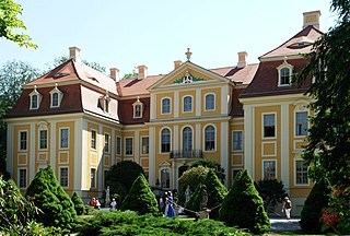
Rammenau is a municipality in the district of Bautzen, in Saxony, Germany. It is known as the birthplace of the well-known German philosopher Johann Gottlieb Fichte.

Abtsbessingen is a municipality in the district Kyffhäuserkreis, in Thuringia, Germany.

The village of Cämmerswalde in the municipality of Neuhausen/Erzgeb. lies in the south of the Saxon district of Mittelsachsen in eastern Germany. The state-recognised spa resort with its 800-year-old history, lies near Seiffen in the eastern part of the Western Ore Mountains not far from the Czech border. The village is a classic Waldhufendorf, with a length of over five kilometres. Cämmerswalde is divided into Oberdorf, Mitteldorf and Niederdorf. Since 1994 Cämmerswalde has belonged to the municipality of Neuhausen/Erzgeb., but used to be an independent parish with the hamlets of Deutschgeorgenthal, Haindorf and, from 1924, Neuwernsdorf and Rauschenbach.
Krumhermersdorf is a village in the large county borough of Zschopau in the district Erzgebirgskreis in eastern Germany. It was first mentioned in the records in 1369.

Rauenstein Castle is a castle in the village of Rauenstein in the town of Pockau-Lengefeld in the Ore Mountains of Central Europe. The castle guarded the crossing over the River Flöha along the road from Freiberg to Annaberg.
Frohnau is a village in the Saxon town of Annaberg-Buchholz in the district of Erzgebirgskreis in southeast Germany. The discovery of silver on the Schreckenberg led in 1496 to the foundation of the neighbouring mining town of Annaberg. The village of Frohnau is best known for its museum of technology, the Frohnauer Hammer, and the visitor mine of Markus Röhling Stolln. The mining area around Frohnau has been selected as a candidate for a UNESCO World Heritage Site: the Ore Mountain Mining Region.
Lauta is a village in the Saxon town of Marienberg in the German district of Erzgebirgskreis.
Jugel is a division of the town of Johanngeorgenstadt in the German district of Erzgebirgskreis. This dispersed settlement is surrounded by woods, is divided into Ober- and Unterjugel and runs along the German-Czech border from the Lehmergrund to the crest of the Western Ore Mountains. In the vicinity lies the 980 metre-high Scheffelsberg. Jugel is a tourist destination for hikers and winter sportsmen.

Satzung is a village in the Saxon municipality of Marienberg, which is in the district of Erzgebirgskreis in the German Ore Mountains.
Krakau (German) or Krakow (Sorbian) was a small town in what is now the district of Bautzen in Saxony, Germany. It was located within the Sorbian area, where many inhabitants traditionally speak the West Slavic Sorbian language, and it shared its name with the much larger Polish city. The town was entirely vacated in 1938 when the area became a military training area. After the war, the town was briefly repopulated, before the Soviet occupation troops again evicted the inhabitants to resume use of the area for military purposes. The town was destroyed.

Störmthal is a village, part of Großpösna in the Leipzig district in Saxony, Germany. It is known for its church in Baroque style. The organ, an early work by Zacharias Hildebrandt, was played and inaugurated by Johann Sebastian Bach and is still in mostly the condition of Bach's time.
Gehringswalde, a so-called Waldhufendorf, is situated about 1.5 km east of Wolkenstein in the Ore Mountains. It extends for about 1.5 km along the valley of a stream which joins the Zschopau river ca. 1.5 km west of Warmbad. The nearby Hüttengrundmühle is also part of the village. The mountain Dreibrüderhöhe lies ca. 3 km east of Gehringswalde.
Niederlauterstein is a village in Saxony which has been incorporated into the town of Marienberg in the district Erzgebirgskreis since 1996.

Muldenhammer is a former subdivision of the town of Eibenstock in the Ore Mountains. It originated from an iron hammer forge, first mentioned in the 16th century and was abandoned in 1974 due to the construction of Eibenstock Dam.
Hundshübel is a village in Erzgebirgskreis district of Saxony, forming a subdivision of the municipality of Stützengrün in the Ore Mountains. It is located north of Eibenstock Dam on federal highway B 169.


