Big Cottonwood Creek

Last updated
Big Cottonwood Creek
Big Cottonwood Creek.jpg
Big Cottonwood Creek near Big Cottonwood Park
Jordan River (Utah) Watershed.jpg
Little Cottonwood Creek and other Salt Lake County streams
Location
CountryUnited States
StateUtah
Physical characteristics
Source 
  location Brighton, Utah, Salt Lake County, Utah
  coordinates 40°36′0″N111°35′0″W / 40.60000°N 111.58333°W / 40.60000; -111.58333
  elevation9,600 ft (2,900 m) [1]
Mouth Jordan River
  location
Murray, Utah, Salt Lake County, Utah
  coordinates
40°40′47″N111°54′42″W / 40.67972°N 111.91167°W / 40.67972; -111.91167
  elevation
4,250 ft (1,300 m) [1]
Length26 mi (42 km) [2]
Basin size43 sq mi (110 km2) [2]
Discharge 
  location Murray, Utah [2]
  average31.3 cu ft/s (0.89 m3/s) [2]
  minimum5.0 cu ft/s (0.14 m3/s)
  maximum380 cu ft/s (11 m3/s)

Big Cottonwood Creek is located in the Wasatch Mountains just east of Salt Lake City. It is part of the Big Cottonwood Creek Watershed, which ranges in elevation from 5,000 to 10,500 feet with the headwaters around 9,600 feet. [3] The creek flows through the Big Cottonwood Canyon in a westerly direction until it emerges into Salt Lake Valley about eighteen miles (29 km) from its highest source. Thence its course is northwesterly through Cottonwood Heights, Holladay, and Murray, Utah for a little over twenty-four miles from the headwaters (39 km) until it empties into the Jordan River about five miles (8.0 km) south of Salt Lake City. [3] The water eventually flows into the Great Salt Lake. In the summer, its waters are all used for irrigation purposes. From its source to its original outlet in the Jordan River is about twenty-six miles. [4]

Contents

Hydrology

The creek flows from around 9,600 feet (2,900 m) at the headwaters to around 4,250 feet (1,300 m) when it reaches the confluence with the Jordan River. The stream flows northwest as it leaves the headwaters near the Brighton Ski Resort and then travels southwest about halfway down the canyon near Reynolds Gulch. At the base of the canyon, the stream leaves the Uinta-Wasatch-Cache National Forest, and a portion of the flow enters the Big Cottonwood Treatment Plant to provide municipal drinking water. At this point, the stream again flows northwest until the confluence with the Jordan River around the Murray area. [5]

Rock glaciers, which are high elevation rock landforms, exist throughout the upper reaches of the canyon. Their bedrock commonly consists of Paleozoic quartzites and carbonates, Mesozoic mets-sedimentary and meta-volcanic rocks, and Cenozoic granitic and gneissic intrusions. These rock glaciers create mountain reservoirs, which are very significant as Utah is prone to severe and extreme droughts. These reservoirs allow the formation and accumulation of ice that is better insulated against rapid changes in air temperature and weather. They are able to sustain very stable conditions. [6] They hold a large amount of water in the Big Cottonwood Watershed.

Brighton, Utah headwaters of Big Cottonwood Creek Usa Utah Brighton Peaks.jpg
Brighton, Utah headwaters of Big Cottonwood Creek

The source waters at the top of the canyon begin near the Brighton Ski Resort and flow from Silver Lake, Twin Lakes Reservoir, Lake Mary, Lake Martha, Lake Catherine, and Dog Lake. Additionally, precipitation and many tributaries along the canyon contribute to Big Cottonwood Creek's water volume. Brighton receives over 50 inches (1,300 mm) of precipitation annually, most in the form of snow. 400 inches of total annual snowfall is measured. The average water yield of Big Cottonwood Creek is 52,864 acre-feet (65,207,000 m3), which is the highest water yield of any Wasatch Front canyon stream in Salt Lake County. This canyon is a protected watershed area under strict management controls since it is a major source of drinking water for Salt Lake City. No dogs or horses are allowed. The water quality provides an excellent source of drinking water. [5]

Flooding is relatively rare for this creek. In the summer of 2010, Big Cottonwood Creek hit 4.1 feet (1.2 m) above the waterline. The flood stage for the urban waterways is 4.2 feet (1.3 m). [7]

Big Cottonwood Canyon and the surrounding Uinta-Wasatch-Cache National Forest have a long history of resource use and development. As Salt Lake City grew through the mid-19th century to the early 20th century, tremendous demands were placed on natural resources through population growth, mining, railroading, and manufacturing. The canyons were stripped of timber, forage, and minerals by 1900. A serious impact was the timber industry's sawmills. The first mills were two mills built in the lower portion of Big Cottonwood Canyon by 1850, and in the next decade, the mills moved up the canyon. Today the canyon continues to be impacted by recreational demands and urban pressure. [5]

Recreation

Outdoor activities in the canyon include fishing, seasonal hunting, camping, hiking, picnicking, sightseeing, biking, rock climbing, skiing, and snowboarding. There are hundreds of places to stop and walk or hike to see Big Cottonwood Creek and its natural water features. The National Forest land in the canyon is intermixed with private land. The private land contains many homes, some right alongside Big Cottonwood Creek. Two large ski resorts are also located in the canyon: Brighton and Solitude. These resorts experience traffic all year. All of these activities further influence this ecosystem. [8]

Flora and Fauna

Bonneville cutthroat trout is a native of Big Cottonwood Creek Bonneville cutthroat.jpg
Bonneville cutthroat trout is a native of Big Cottonwood Creek

Big Cottonwood creek is surrounded by a wide variety of native trees including the quaking aspen, gamble oak, douglas-fir, blue spruce, engelmann spruce, mountain mahogany, lodgepole pine, white fir, bigtooth maple, rocky mountain maple, rocky mountain juniper and boxelder maple. [9] Invasive trees and plants have become a problem because they can throw off the balance of an ecosystem. They can affect water quality, which leads to issues for biodiversity, habitats, erosion, soil erosion, and affects the way that native species can survive and reproduce. [10]

Big Cottonwood Creek is home to rainbow trout (Oncorhynchus mykiss), brook trout (Salvelinus fontinalis), and brown trout (Salmo trutta) and the native Bonneville cutthroat trout (Oncorhynchus clarki utah). The Utah Division of Wildlife Resources stocks the creek with rainbow trout annually near Silver Lake. The Utah Division of Wildlife Resources has identified Big Cottonwood Creek as a Class II Fishery. This classifies the area as "a moderate to large productive stream with high aesthetic value where fishing and other recreational uses should be the primary consideration". It was determined to be an especially important water body due to its capacity to provide a strong resident trout fishery close to a metropolitan area. [5]

See also

Related Research Articles

<span class="mw-page-title-main">Wasatch Range</span> Sub-range of the Rocky Mountains in the western United States

The Wasatch Range or Wasatch Mountains is a mountain range in the western United States that runs about 160 miles (260 km) from the Utah-Idaho border south to central Utah. It is the western edge of the greater Rocky Mountains, and the eastern edge of the Great Basin region. The northern extension of the Wasatch Range, the Bear River Mountains, extends just into Idaho, constituting all of the Wasatch Range in that state.

<span class="mw-page-title-main">Jordan River (Utah)</span> River feeding the Great Salt Lake, US

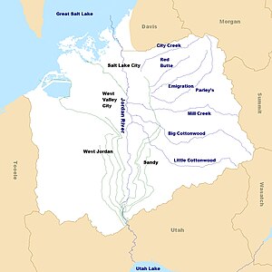
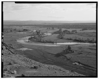
The Jordan River is a 51.4-mile-long (82.7 km) river in the U.S. state of Utah. Regulated by pumps at its headwaters at Utah Lake, it flows northward through the Salt Lake Valley and empties into the Great Salt Lake. Four of Utah's six largest cities border the river: Salt Lake City, West Valley City, West Jordan, and Sandy. More than a million people live in the Jordan Subbasin, part of the Jordan River watershed that lies within Salt Lake and Utah counties. During the Pleistocene, the area was part of Lake Bonneville.

<span class="mw-page-title-main">Uinta Mountains</span> Mountain range in northeastern Utah and northwestern Colorado in the United States

The Uinta Mountains are an east-west trending chain of mountains in northeastern Utah extending a short distance into northwest Colorado and slightly into southwestern Wyoming in the United States. As a subrange of the Rocky Mountains, they are unusual for being the highest range in the contiguous United States running east to west, and lie approximately 100 miles (160 km) east of Salt Lake City. The range has peaks ranging from 11,000 to 13,528 feet, with the highest point being Kings Peak, also the highest point in Utah. The Mirror Lake Highway crosses the western half of the Uintas on its way to Wyoming. Utah State Route 44 crosses the east end of the Uintas between Vernal and Manila.

<span class="mw-page-title-main">Little Cottonwood Canyon</span> Canyon in Northern Utah

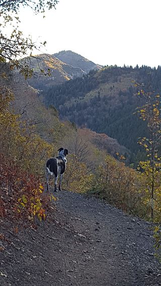
Little Cottonwood Canyon lies within the Wasatch-Cache National Forest along the eastern side of the Salt Lake Valley, roughly 15 miles from Salt Lake City, Utah. The canyon is part of Granite, a CDP and "Community Council" designated by Salt Lake County. The canyon is a glacial trough, carved by an alpine glacier during the last ice age, 15,000 to 25,000 years ago. A number of rare and endemic plant species are found in the canyon's Albion Basin. Introduced Mountain goats inhabit the surrounding mountains.

<span class="mw-page-title-main">Solitude Mountain Resort</span> Ski resort in Brighton, Utah, United States

Solitude Mountain Resort is a ski resort located in the Big Cottonwood Canyon of the Wasatch Mountains, thirty miles southeast of Salt Lake City, Utah. With 66 trails, 1,200 acres (4.9 km2) and 2,047 feet (624 m) vertical, Solitude is one of the smaller ski resorts near Salt Lake City, along with its neighbor Brighton. It is a family-oriented mountain, with a wider range of beginner and intermediate slopes than other nearby ski resorts; 50% of its slopes are graded "beginner" or "intermediate," the highest such ratio in the Salt Lake City area. Solitude was one of the first major US resorts to adopt an RFID lift ticket system, allowing lift lines to move more efficiently. It was followed by Alta Ski Area in 2007. Solitude is adjacent to Brighton Ski Resort near the top of Big Cottonwood Canyon. Solitude and Brighton offer a common "Solbright Pass" which provides access to both resorts for a nominal surcharge.

<span class="mw-page-title-main">Big Cottonwood Canyon</span> Canyon in Salt Lake County, Utah, United States

Big Cottonwood Canyon is a canyon in the Wasatch Range 12 miles (19 km) southeast of Salt Lake City in the U.S. state of Utah. The 15-mile (24 km)-long canyon provides hiking, biking, picnicking, rock-climbing, camping, and fishing in the summer. Its two ski resorts, Brighton and Solitude, are popular among skiers and snowboarders. The canyon is accessed by The Big Cottonwood Canyon Scenic Byway (SR-190), which runs its length to Guardsman Pass at the top of the canyon, allowing travel to Park City in the summer months.

<span class="mw-page-title-main">Lone Peak Wilderness</span> Wilderness area in Utah and Salt Lake counties in Utah, United States

The Lone Peak Wilderness is a 30,088-acre (121.76 km2) wilderness area located within the Uinta and the Wasatch-Cache National Forests in the U.S. state of Utah.

<span class="mw-page-title-main">Tushar Mountains</span> Mountain range in Utah, United States

The Tushar Mountains are the third-highest mountain range in Utah after the Uinta Mountains and the La Sal Range. Located in the Fishlake National Forest, Delano Peak, 12,174 ft  NAVD 88, is the highest point in both Beaver and Piute counties and has a prominence of 4,689 ft. Delano Peak is named for Columbus Delano (1809–1896), Secretary of the Interior, during the Grant administration. The Tushars receive an ample amount of snow annually even though they are situated within the rainshadow of the Sierra Nevada range in California and the Snake Range located in Nevada.

<span class="mw-page-title-main">Utah State Route 152</span>

State Route 152 (SR-152) is a state highway in the suburbs of Salt Lake City, Utah connecting SR-71 in Murray to I-215 and city-maintained Highland Drive in Cottonwood Heights, though for almost all of its length it forms the border between Murray and Holladay. The route, which is 3.04 miles (4.89 km), is laid on the entire length of the Van Winkle Expressway and a portion of Highland Drive.

<span class="mw-page-title-main">Utah State Route 190</span>

State Route 190 (SR-190) or the Big Cottonwood Canyon Scenic Byway is primarily an east and west state highway and scenic highway in eastern Salt Lake County, Utah, United States, that begins at Interstate 215 (I-215), runs through Big Cottonwood Canyon, and ends at the Salt Lake and Wasatch county line.

<span class="mw-page-title-main">Millcreek Canyon (Salt Lake County, Utah)</span>

Millcreek Canyon is a canyon in the Wasatch Mountains and part of Millcreek City on the east side of the Salt Lake Valley, Utah. It is a popular recreation area both in the summer and in the winter. It was named by Brigham Young on August 22, 1847, before all of the mills that were built in and below the densely forested canyon. It is home to two restaurants and six Boy Scout Day Camps.

<span class="mw-page-title-main">Duchesne River</span> River in Utah, United States

The Duchesne River, located in the Uintah Basin region of Utah in the western United States, is a tributary of the Green River. The watershed of the river covers the Northeastern corner of Utah. The Duchesne River is 115 miles (185 km) long, and drains a total land area of 3,790 square miles (9,800 km2).

<span class="mw-page-title-main">Little Cottonwood Creek (Salt Lake County, Utah)</span> River in Utah, United States

Little Cottonwood Creek is one of the principal streams entering Salt Lake Valley from the east. The creek rises near the summit of the Wasatch Mountains, a short distance south of the ski resort town of Alta, and flows in a westerly direction through Little Cottonwood Canyon until it emerges into Salt Lake Valley about eleven miles from its source. Thence its course is north westerly through Sandy, Midvale and Murray, Utah until it empties into the Jordan River, about six miles south of Salt Lake City. Its whole length is nearly 27 miles (43 km). The headwaters of Little Cottonwood Creek are in Little Cottonwood Canyon, a glaciated canyon in Uinta-Wasatch-Cache National Forest and the Wasatch and Uinta Mountains eco-region. One of the main tributaries of the creek rises in Cecret Lake, a small sheet of water situated near Alta. The entire Little Cottonwood Creek drainage basin encompasses 46 square miles (120 km2), ranging in elevation from about 4,490 to 11,500 feet.

<span class="mw-page-title-main">Red Butte Creek (Salt Lake County, Utah)</span> Natural watercourse in Salt Lake County, Utah, United States

Red Butte Creek is a small stream whose headwaters are found in the northeast part of Salt Lake County, Utah, United States. It flows west through the Red Butte Garden and Arboretum, by the University of Utah, Fort Douglas and flows southwesterly to Salt Lake City’s Liberty Park. With 7.25 sq mi (18.8 km2) of watershed, Red Butte Canyon is the smallest canyon of the seven canyons in eastern Salt Lake County. Its elevation ranges from 5,000 to 8,000 ft above sea level.

<span class="mw-page-title-main">East Canyon Creek</span> Stream in Utah, US

East Canyon Creek is a 40.5-mile-long (65.2 km) north by northwest-flowing stream that begins northwest of Kimball Junction in Summit County, Utah, on the east side of the summit of the Wasatch Range, and flows to its confluence with the Weber River in Morgan County, Utah. East Canyon Creek is one of four major tributaries of the Weber River, which in turn, flows to the Great Salt Lake.

<span class="mw-page-title-main">Guardsman Pass</span> Mountain pass in Utah, US

Guardsman Pass (elevation 9,717 feet is a high mountain pass in the Wasatch Mountains of Utah. The pass is located on the boundaries of the Uinta-Wasatch-Cache National Forest to the west, and the Bonanza Flats backcountry area to the east.

<span class="mw-page-title-main">Mount Superior</span> Mountain in the American state of Utah

Mount Superior is an 11,045 feet (3,367 m) mountain peak in the Uinta-Wasatch-Cache National Forest in Salt Lake County, Utah, United States.

<span class="mw-page-title-main">White River (Price River tributary)</span> River in Utah, United States

The White River is a 8-mile-long (13 km) southeastward flowing river in Wasatch and Utah Counties in eastern Utah. The White River is a tributary to the Price River, which is, in turn, a tributary to the Green River, and then to the Colorado River.

<span class="mw-page-title-main">Kimball Creek (Summit County, Utah)</span> Stream in Summit County, Utah, US

Kimball Creek is a 1.9-mile-long (3.1 km) west-flowing stream that begins 5.7 miles (9.2 km) north of Park City, Utah on the east side of the summit of the Wasatch Range. It is one of the upper reaches of the East Canyon Creek watershed in Summit County, Utah, which in turn is a tributary to the Weber River, and ultimately to the Great Salt Lake.

<span class="mw-page-title-main">McLeod Creek</span> Stream in Summit County, Utah, US

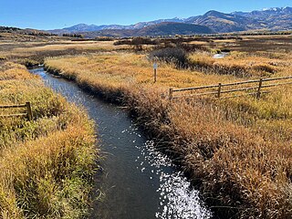
McLeod Creek is a 9.0-mile-long (14.5 km) northwards-flowing stream that begins 1.3 miles (2.1 km) southwest of Park City, Utah on the east side of the summit of the Wasatch Range. It is one of the upper reaches of the East Canyon Creek watershed in Summit County, Utah, which flows to the Weber River ad ultimately the Great Salt Lake.

References

  1. 1 2 Google Earth elevation for GNIS coordinates. Retrieved on 2010-06-08.
  2. 1 2 3 4 "#390 BIG COTTONWOOD CREEK @ 300 WEST" (PDF). SALT LAKE COUNTY PUBLIC WORKS DEPARTMENT ENGINEERING DIVISION. September 2004. Retrieved 2010-06-08.
  3. 1 2 Berni, Lynn (2014). "Stream Care Guide" (PDF). Jordan River Commission. Retrieved 22 February 2023.
  4. Andrew Jenson; The Historical record: a monthly periodical devoted exclusively to historical, biographical, chronological and statistical matters, Volumes 5-8 Publisher: A. Jenson., 1889
  5. 1 2 3 4 Kate Schwager, Paul K. Cowley; BIG COTTONWOOD CREEK Stream Survey Report. United States Department of Agriculture. Wasatch-Cache National Forest Salt Lake Ranger District November 2000
  6. Millar, Constance (10 May 2019). "Geographic, hydrological, and climatic significance of rock glaciers in the Great Basin, USA". Arctic, Antarctic, and Alpine Research. 51: 232–249. doi: 10.1080/15230430.2019.1618666 . S2CID   197579321 via Taylor & Francis Online.
  7. Stettler, Jeremiah; Cleanup begins as flooding eases. The Salt Lake Tribune June 8, 2010.
  8. Brett Prettyman, Tom Wharton; Fishing Utah. Publisher Globe Pequot, 2001 ISBN   1-56044-983-7
  9. "Save Our Canyons - Flora and Fauna". saveourcanyons.org. Retrieved 2023-02-25.
  10. "Invasive Species Program | Cottonwood Canyons Foundation". 2020-10-26. Retrieved 2023-02-25.