Little Cottonwood Creek (Salt Lake County, Utah)

Last updated
Little Cottonwood Creek
Murray City Park, Murray, Utah.jpg
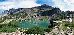
The Little Cottonwood Creek in Murray City Park, Murray, Utah
Jordan River (Utah) Watershed.jpg
Little Cottonwood Creek and other Salt Lake County streams
Location
Country United States
State Utah
Physical characteristics
Source 
  location Cecret Lake, Alta, Utah, Salt Lake County, Utah
  coordinates 40°34′12″N111°37′19.2″W / 40.57000°N 111.622000°W / 40.57000; -111.622000
  elevation11,500 ft (3,500 m) [1]
Mouth Jordan River
  location
Murray, Utah, Salt Lake County, Utah
  coordinates
40°39′57″N111°54′27″W / 40.66583°N 111.90750°W / 40.66583; -111.90750 Coordinates: 40°39′57″N111°54′27″W / 40.66583°N 111.90750°W / 40.66583; -111.90750
  elevation
4,490 ft (1,370 m) [1]
Length27.72 mi (44.61 km) [2]
Basin size46 sq mi (120 km2) [2]
Discharge 
  location Murray, Utah [2]
  average111 cu ft/s (3.1 m3/s) [2]
  minimum99 cu ft/s (2.8 m3/s)
  maximum5,290 cu ft/s (150 m3/s)

Little Cottonwood Creek is one of the principal streams entering Salt Lake Valley from the east. The creek rises near the summit of the Wasatch Mountains, a short distance south of the ski resort town of Alta, and flows in a westerly direction through Little Cottonwood Canyon until it emerges into Salt Lake Valley about eleven miles from its source. Thence its course is north westerly through Sandy, Midvale and Murray, Utah until it empties into the Jordan River, about six miles south of Salt Lake City. [3] Its whole length is nearly 27 miles (43 km). The headwaters of Little Cottonwood Creek are in Little Cottonwood Canyon, a glaciated canyon in Uinta-Wasatch-Cache National Forest and the Wasatch and Uinta Mountains eco-region. One of the main tributaries of the creek rises in Cecret Lake, a small sheet of water situated near Alta. The entire Little Cottonwood Creek drainage basin encompasses 46 square miles (120 km2), ranging in elevation from about 4,490 to 11,500 feet (1,370 to 3,510 m). [4]

Contents

Communities were founded around the creek soon after the pioneer settlement of Salt Lake Valley in 1847 and supported agricultural activities. Following the discovery of gold, silver, copper, and lead in nearby canyons in the 1870s, ore-refining activities brought an influx of people to these communities. During the mid-to the late 1900s, residential land use replaced agriculture as the dominant land-use type in the lower Little Cottonwood Creek drainage basin as the population of Salt Lake Valley expanded. [5]

Land cover upstream from the mouth of Little Cottonwood Canyon is 60 percent forest land and 33 percent rangeland. The watershed in Little Cottonwood Canyon is protected as a drinking water source but receives extensive recreational use. The urbanized part of the Little Cottonwood Creek drainage basin includes that part from the mouth of Little Cottonwood Canyon to the confluence with the Jordan River. The stream provides electrical power generation for Murray City.

Cecret Lake, headwater of Little Cottonwood Creek Cecret Lake Panorama Albion Basin Alta Utah July 2009.jpg
Cecret Lake, headwater of Little Cottonwood Creek

The first legitimate mining operation in Little Cottonwood Canyon was established in 1865. The ore deposits in Little Cottonwood Canyon yielded principally silver and lead with some copper, gold, and zinc. These ore deposits were formed mainly in shale, limestone, and dolomite. Galena or lead sulfide was the common primary lead mineral of the area. Argentite was found in most primary ores and was probably an abundant primary silver mineral. Ore production varied with time because of the nature of the deposits and the scattered control of holdings. The 1870s were especially productive when rich deposits were mined. Several smelters operated along Little Cottonwood Creek during the 1870s. Smelting operations produced a variety of by-products that included arsenic, matte, arsenical speiss, and slag.

Past mining activities and ore-smelting operations continue to influence the water chemistry of the stream. Mine and smelter tailings in the Little Cottonwood Creek drainage basin can contribute trace metals to the stream. Metals from fluvial tailings deposits in the stream can be re-suspended and dissolved in the stream. Currently, the greatest threat to the streams ecosystem is pesticides from residential run-off.

Hydrology

The hydrology of the urbanized reach of Little Cottonwood Creek is highly variable and complex because of the canals and diversion structures employed by different water users. Source water for the urban reach of Little Cottonwood Creek varies spatially and seasonally. Sources include snowmelt, stormwater, groundwater, irrigation return, and water imported from the Jordan River. The effect that each of these sources has on stream quality varies seasonally and with stream flow. About 85 percent of the runoff at the mouth of Little Cottonwood Creek was from snowmelt.

Rainbow trout, commonly found in Little Cottonwood Creek. Rainbow trout FWS 1.jpg
Rainbow trout, commonly found in Little Cottonwood Creek.

The hydrology of Little Cottonwood Creek is typical of that of many urban streams along the Wasatch Front and in the Intermountain West. A system of diversions for withdrawal of irrigation water began to be developed on many Wasatch Front streams soon after settlers arrived in Salt Lake Valley in 1847. As the population of the Wasatch Front increased, more of the water in valley streams was needed for drinking and domestic purposes. To meet domestic needs, water is withdrawn from several Wasatch Front streams, including Little Cottonwood Creek, as they emerge from headwater canyons and enter Salt Lake Valley. The water needs of irrigators downstream from the canyon mouths are satisfied with water diverted out of the Jordan River and transported across the valley in a system of canals. Some of the water from the Jordan River is imported to the urbanized reach of Little Cottonwood Creek. [5]

The flood stage for the urban waterways is 5.7 feet (1.7 m). Notable flooding is rare, with significant flooding in 1983 and as recently as the summer of 2010, when the waterline was 6.3 feet (1.9 m) above bank level. [6]

Fauna

The Utah Division of Wildlife Resources stocks the creek with 1,000 trout yearly. The trout are primarily rainbow and Bonneville cutthroat trout. As the higher elevations of the creek still are affected by early mining operations, there is a little carryover from each year’s stocking. [7]

See also

Related Research Articles

<span class="mw-page-title-main">Murray, Utah</span> City in Utah, United States

Murray is a city situated on the Wasatch Front in the core of Salt Lake Valley in the U.S. state of Utah. Named for territorial governor Eli Murray, it is the state's fourteenth largest city. According to the 2020 census, Murray had a population of 50,637. Murray shares borders with Taylorsville, Holladay, South Salt Lake and West Jordan, Utah. Once teeming with heavy industry, Murray's industrial sector now has little trace and has been replaced by major mercantile sectors. Known for its central location in Salt Lake County, Murray has been called the Hub of Salt Lake County. Unlike most of its neighboring communities, Murray operates its own police, fire, power, water, library, and parks and recreation departments and has its own school district. While maintaining many of its own services, Murray has one of the lowest city tax rates in the state.

<span class="mw-page-title-main">Lake Bonneville</span> Former pluvial lake in western North America

Lake Bonneville was the largest Late Pleistocene paleolake in the Great Basin of western North America. It was a pluvial lake that formed in response to an increase in precipitation and a decrease in evaporation as a result of cooler temperatures. The lake covered much of what is now western Utah and at its highest level extended into present-day Idaho and Nevada. Many other hydrographically closed basins in the Great Basin contained expanded lakes during the Late Pleistocene, including Lake Lahontan in northwestern Nevada.

<span class="mw-page-title-main">Wasatch Range</span> Mountain range in Utah, United States

The Wasatch Range or Wasatch Mountains is a mountain range in the western United States that runs about 160 miles (260 km) from the Utah-Idaho border south to central Utah. It is the western edge of the greater Rocky Mountains, and the eastern edge of the Great Basin region. The northern extension of the Wasatch Range, the Bear River Mountains, extends just into Idaho, constituting all of the Wasatch Range in that state.

<span class="mw-page-title-main">Jordan River (Utah)</span> River feeding the Great Salt Lake, USA

The Jordan River, in the state of Utah, United States, is a river about 51 miles (82 km) long. Regulated by pumps at its headwaters at Utah Lake, it flows northward through the Salt Lake Valley and empties into the Great Salt Lake. Four of Utah's six largest cities border the river: Salt Lake City, West Valley City, West Jordan, and Sandy. More than a million people live in the Jordan Subbasin, part of the Jordan River watershed that lies within Salt Lake and Utah counties. During the Pleistocene, the area was part of Lake Bonneville.

<span class="mw-page-title-main">Santa Ana River</span> River in California, United States

The Santa Ana River is the largest river entirely within Southern California in the United States. It rises in the San Bernardino Mountains and flows for most of its length through San Bernardino and Riverside Counties, before cutting through the northern Santa Ana Mountains via Santa Ana Canyon and flowing southwest through urban Orange County to drain into the Pacific Ocean. The Santa Ana River is 96 miles (154 km) long, and its drainage basin is 2,650 square miles (6,900 km2) in size.

<span class="mw-page-title-main">Uinta Mountains</span> Mountain range in northeastern Utah and northwestern Colorado in the United States

The Uinta Mountains are an east-west trending chain of mountains in northeastern Utah extending slightly into southern Wyoming in the United States. As a subrange of the Rocky Mountains, they are unusual for being the highest range in the contiguous United States running east to west, and lie approximately 100 miles (160 km) east of Salt Lake City. The range has peaks ranging from 11,000 to 13,528 feet, with the highest point being Kings Peak, also the highest point in Utah. The Mirror Lake Highway crosses the western half of the Uintas on its way to Wyoming.

<span class="mw-page-title-main">Sevier River</span> River in central Utah, United States

The Sevier River is a 400-mile (640 km)-long river in the Great Basin of southwestern Utah in the United States. Originating west of Bryce Canyon National Park, the river flows north through a chain of high farming valleys and steep canyons along the west side of the Sevier Plateau before turning southwest and terminating in the endorheic basin of Sevier Lake in the Sevier Desert. It is used extensively for irrigation along its course, with the consequence that Sevier Lake is usually dry.

Little Cottonwood Canyon

Little Cottonwood Canyon lies within the Wasatch-Cache National Forest along the eastern side of the Salt Lake Valley, roughly 15 miles from Salt Lake City, Utah. The canyon is part of Granite, a CDP and "Community Council" designated by Salt Lake County. The canyon is a glacial trough, carved by an alpine glacier during the last ice age, 15,000 to 25,000 years ago. A number of rare and endemic plant species are found in the canyon's Albion Basin. Mountain goats inhabit the surrounding mountains.

Salt Lake Valley Geographic depression in northern Utah, US, containing Salt Lake City and its suburbs

Salt Lake Valley is a 500-square-mile (1,300 km2) valley in Salt Lake County in the north-central portion of the U.S. state of Utah. It contains Salt Lake City and many of its suburbs, notably Murray, Sandy, South Jordan, West Jordan, and West Valley City; its total population is 1,029,655 as of 2010. Brigham Young said, "this is the right place," when he and his fellow Mormon settlers moved into Utah after being driven out of several states.

Weber River River in Utah, United States

The Weber River is a c. 125-mile (201 km) long river of northern Utah, United States. It begins in the northwest of the Uinta Mountains and empties into the Great Salt Lake. The Weber River was named for American fur trapper John Henry Weber.

<span class="mw-page-title-main">Provo River</span> River in Utah, United States

The Provo River is located in Utah County and Wasatch County, Utah, in the United States. It rises in the Uinta Mountains at Wall Lake and flows about 71 miles (114 km) southwest to Utah Lake at the city of Provo, Utah.

<span class="mw-page-title-main">American Fork (river)</span> River in Utah County, Utah, United States

The American Fork is a river in Utah County, Utah, United States.

Forest City, Utah Ghost town in Utah, United States

Forest City is a ghost town in Utah County, Utah, United States. It is located in the valley of Dutchman Flat in the upper part of American Fork Canyon, in the Uinta National Forest. A silver mining town just over the mountain from Alta, Forest City was inhabited about 1871–1880. The town grew up around the smelter that was built to process ore from the canyon's mines. The American Fork Railroad, which was intended to serve Forest City and the smelter, stopped short of its destination due to engineering difficulties. Transportation costs rose too high for the mines to continue operating profitably. As the smelter, mines, and railroad closed down, Forest City was abandoned.

Utah State Route 190

State Route 190 (SR-190) or the Big Cottonwood Canyon Scenic Byway is primarily an east and west state highway and scenic highway in eastern Salt Lake County, Utah, United States, that begins at Interstate 215 (I-215), runs through Big Cottonwood Canyon, and ends at the Salt Lake and Wasatch county line.

<span class="mw-page-title-main">Big Cottonwood Creek</span> River in Utah, United States

Big Cottonwood Creek is one of the largest streams entering Salt Lake Valley from the east from the Wasatch Mountains. The creek flows through the Big Cottonwood Canyon in a westerly direction until it emerges into Salt Lake Valley about eighteen miles (29 km) from its highest source. Thence its course is northwesterly through Cottonwood Heights, Holladay, and Murray, Utah until it empties into the Jordan River about five miles (8.0 km) south of Salt Lake City. In the summer, its waters are all used for irrigation purposes. From its source to its original outlet in the Jordan River is about twenty-six miles.

<span class="mw-page-title-main">Red Butte Creek (Salt Lake County, Utah)</span> Natural watercourse in Salt Lake County, Utah, United States

Red Butte Creek is a small stream whose headwaters are found in the northeast part of Salt Lake County, Utah, United States. It flows west through the Red Butte Garden and Arboretum, by the University of Utah, Fort Douglas and flows southwesterly to Salt Lake City’s Liberty Park. Despite 7.25 sq mi (18.8 km2) of the watershed, Red Butte Canyon is the smallest canyon of the seven canyons in eastern Salt Lake County. Its elevation ranges from 5,000 to 8,000 ft above sea level.

Hobble Creek is a stream in Utah County, Utah. Its mouth lies at at its confluence with Utah Lake, at an elevation 4,491 feet (1,369 m). Its source is located at 40°09′45″N111°30′03″W, at the confluence of the Left Fork and Right Fork Hobble Creek in the Wasatch Range. The source lies at an elevation 5,043 feet (1,537 m). The unincorporated community of Hobble Creek occupies the valley of the creek and its Left Fork.

The geology of Utah includes rocks formed at the edge of the proto-North American continent during the Precambrian. A shallow marine sedimentary environment covered the region for much of the Paleozoic and Mesozoic, followed by dryland conditions, volcanism and the formation of the basin and range terrain in the Cenozoic. Utah is a state in the western United States.

<span class="mw-page-title-main">White River (Price River tributary)</span> River in Utah, United States

The White River is a 8-mile-long (13 km) southeastward flowing river in Wasatch and Utah Counties in eastern Utah. The White River is tributary to the Price River, which is, in turn, tributary to the Green River, and then to the Colorado River.

References

  1. 1 2 Google Earth elevation for GNIS coordinates. Retrieved on 2010-06-08.
  2. 1 2 3 4 "Hydrology and Water Quality of an Urban Stream Reach in the Great Basin—Little Cottonwood Creek near Salt Lake City, Utah, Water Years 1999–2000" (PDF). United States Geological Survey. 2000-06-06. Retrieved 2010-06-08.
  3. Andrew Jenson; The Historical record: a monthly periodical devoted exclusively to historical, biographical, chronological, and statistical matters, Volumes 5-8
  4. Wood, A.J., Lammers, D.A., Bryce, S.A., Omernik, J.M., Denton, R.L., Domeier, M., and Comstock, J.A., 2001, Ecoregions of Utah: Reston, Virginia, U.S. Geological Survey
  5. 1 2 Steven J. Gerner and Kidd M. Waddell; Hydrology and Water Quality of an Urban Stream Reach in the Great Basin—Little Cottonwood Creek near Salt Lake City, Utah, Water Years 1999-2000—Water-Resources Investigations Report 02–4276 National Water-Quality Assessment Program study unit Great Salt Lake Basins. US Geological Survey.
  6. Stettler, Jeremiah; Cleanup begins as flooding eases. The Salt Lake Tribune June 8, 2010.
  7. Brett Prettyman, Tom Wharton. Fishing Utah. Publisher Globe Pequot, 2001. ISBN   1-56044-983-7

Commons-logo.svg Media related to Little Cottonwood Creek (Salt Lake County, Utah) at Wikimedia Commons