
The Dardanelles, also known as the Strait of Gallipoli and in Classical Antiquity as the Hellespont, is a narrow, natural strait and internationally significant waterway in northwestern Turkey that forms part of the continental boundary between Asia and Europe and separates Asian Turkey from European Turkey. Together with the Bosporus, the Dardanelles forms the Turkish Straits.
Çanakkale Province is a province of Turkey, located in the northwestern part of the country. It takes its name from the city of Çanakkale. Its area is 9,817 km2, and its population is 559,383 (2022).

Edirne Province is a Turkish province located in East Thrace. Part of European Turkey, it is one of only three provinces located entirely within continental Europe. Its area is 6,145 km2, and its population is 414,714 (2022). Edirne Province is bordered by Tekirdağ Province and Kırklareli Province to the east, and the Gallipoli peninsula of Çanakkale Province to the south-east. It shares international borders with Bulgaria to the north and Greece to the west. Edirne is the capital of the province, and the largest city. It is the only province of Turkey that borders Greece.

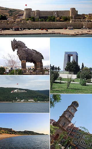
Çanakkale, formerly known in English as Dardanelles, is a city and seaport in Turkey on the southern shore of the Dardanelles at their narrowest point. It is the seat of Çanakkale Province and Çanakkale District. Its population is 143,622 (2021).

Selçuk is a municipality and district of İzmir Province, Turkey. Its area is 317 km2, and its population is 38,151 (2022). The town Selçuk is located 2 kilometres northeast of the ancient city of Ephesus, that was once home to the Temple of Artemis, one of the Seven Wonders of the Ancient World.

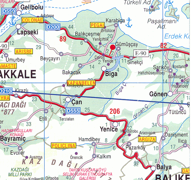
The Biga River is a small river in Çanakkale Province in northwestern Turkey. The river begins at the base of Mount Ida and trends generally northeasterly to the Sea of Marmara. It is about 50 kilometres (31 mi) east of the Dardanelles. It flows past the towns of Çan and Biga and enters the Sea of Marmara at Karabiga. It is also known as the Çan and the Kocabaş.

Bartın is a city in northern Turkey, near the Black Sea. It is the seat of Bartın Province and Bartın District. Its population is 81,692 (2021).

Karahallı is a town in Uşak Province in the inner Aegean region of Turkey. It is the seat of Karahallı District. Its population is 5,672 (2022). Karahallı is at a distance of 62 km (39 mi) from the province center of Uşak lying to its north.
Not to be confused with Ayvalık.
Çan is a town in Çanakkale Province in the Marmara region of Turkey. It is the seat of Çan District. Its population is 30,970 (2021). The town lies at an elevation of 67 m (220 ft).

Eceabat, formerly Maydos, is a small town in Çanakkale Province in the Marmara Region of Turkey, located on the eastern shore of the Gelibolu Peninsula, on the Dardanelles Strait. It is the seat of Eceabat District. Its population is 5,636 (2021). The town lies at sea level. It is an almost entirely modern town.

Lapseki is a town in Çanakkale Province, Turkey. It is the seat of Lapseki District. Its population is 14,984 (2021). The mayor is Eyüp Yılmaz (AKP).

İnebolu is a town and district of the Kastamonu Province in the Black Sea region of Turkey. It is 590 km (367 mi) from Istanbul by road and 89 km (55 mi) north of Kastamonu. It is a typical Black Sea port town with many fine examples of traditional domestic architecture. It is the seat of İnebolu District. Its population is 10,594 (2021).
Bolayır is a village in the Gelibolu District of Çanakkale Province, situated on the Gallipoli Peninsula in the European part of Turkey. Its population is 1,053 (2021).
Karabiga (Karabuga) is a town (belde) in the Biga District, Çanakkale Province, Turkey. Its population is 2,962 (2021). It is located at the mouth of the Biga River, on a small east-facing bay, known as Karabiga Bay. Its ancient name was Priapus or Priapos.
Gümüşçay is a town (belde) in the Biga District, Çanakkale Province, Turkey. Its population is 2,123 (2021). It is situated in the Anatolian portion of the province 10 kilometres (6.2 mi) south of Marmara Sea coast. The distance to Biga is 6 kilometres (3.7 mi). The settlement was an Ottoman district center named Güvercinli. The mosque of Gümüşçay, the Nasuh Çelebi mosque was built during the reign of Mahmut I (1730-1754). The settlement was declared a seat of township in 1949. The main economic sector of the town is agriculture.
Erenköy is a village in the Çanakkale District of Çanakkale Province, Turkey. Its population is 1,480 (2021). In ancient times, the area was known as Ofrinio; later, it was known as Renkioi, which was later changed to Erenköy. The town was at one point renamed İntepe, but the name was changed back to Erenköy in 2010. Before the 2013 reorganisation, it was a town (belde).
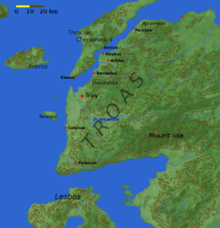
Biga Peninsula is a peninsula in Turkey, in the northwest part of Anatolia. It is also known by its ancient name Troad (Troas).
Didymateiche, or Didymon Teichos, was a town of ancient Mysia. It belonged to the Delian League since it appears in tribute records of Athens between the years 454/3 and 418/7 BCE. Polybius writes that it was among the places that were conquered by Attalus I, after the city of Carseae.


