Xanthi

Last updated

Xanthi
Ξάνθη
Xanthi pagebanner.jpg
KsANThE PALIA POLE.jpg
Xanthi Kathedral Church.jpg
Laographiko Mouseio Ksanthes!!.jpg
Xanthi's clock.jpg
Kentrike plateia Ksanthes.jpg
KsANThE PALIA POLE PLATEIA METROPOLEOS.jpg
From top left: aerial view of the city, Xanthi old town, Cathedral of St. Sophia The Wisdom of God, folk and history museum, Xanthi clocktower, Central square, a church in the old town.
Greece location map.svg
Red pog.svg
Xanthi
Location within the region
2011 Dimos Xanthis.svg
Coordinates: 41°8′N24°53′E / 41.133°N 24.883°E / 41.133; 24.883
CountryGreece
Geographic region Thrace
Administrative region Eastern Macedonia and Thrace
Regional unit Xanthi
Government
  MayorEfstratios Kontos ( New Democracy )
Area
  Municipality495.1 km2 (191.2 sq mi)
  Municipal unit153.1 km2 (59.1 sq mi)
Elevation
82 m (269 ft)
Population
 (2021) [1]
  Municipality66,875
  Density140/km2 (350/sq mi)
  Municipal unit
65,240
  Municipal unit density430/km2 (1,100/sq mi)
  Community
58,760
Time zone UTC+2 (EET)
  Summer (DST) UTC+3 (EEST)
Postal code
67100, 67131, 67132, 67132
Area code(s) 2541
Vehicle registration AH
Website www.cityofxanthi.gr

Xanthi [lower-alpha 1] is a city in the region of Western Thrace, northeastern Greece. It is the capital of the Xanthi regional unit of the region of East Macedonia and Thrace.

Contents

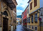
Amphitheatrically built on the foot of Rhodope mountain chain, the city is divided by the Kosynthos River, into the west part, where the old and the modern town are located, and the east part that boasts a rich natural environment. The "Old Town of Xanthi" is known throughout Greece for its distinctive architecture, combining many Byzantine Greek churches with neoclassical mansions of Greek merchants from the 18th and 19th centuries and Ottoman-Era mosques. [2] Other landmarks in Xanthi include the Archaeological Museum of Abdera and the Greek Folk Art Museum.

Xanthi is famous throughout Greece (especially Macedonia and Thrace) for its annual spring carnival [2] (Greek: καρναβάλι) which has a significant role in the city's economy. Over 40 cultural associations from around Greece participate in the carnival program. The festivities which take place during the period include concerts, theatre plays, music and dance nights, exhibitions, a cycling event, games on the streets, and re-enactments of old customs. [2]

Name

There are two theories regarding the origin of its name: it was either named after a daughter of Oceanus and Tethys, or after Xanthi, one of the Amazons that ruled the region, according to legend.

Xanthi is known as İskeçe in Turkish [3] and Скеча (Skecha) or Ксанти (Ksanti) in Bulgarian. [4]

History

Xanthi is sometimes identified with the ancient city of Xantheia mentioned in the 1st century BC by the geographer Strabo, [5] but it was not mentioned by any other ancient historian. [5] It began as a small village and experienced all the tumultuous periods of the history of Thrace, such as raids, disasters, ethnic conflicts, civil wars. The population of the region of Xanthi had dwindled down to almost nothing, as the region was depopulated in the 3rd century AD [5] and almost everything had been destroyed when the Ottomans conquered the region in 1361. For this reason, the Ottomans brought Turkish settlers from within of Asia Minor, which is how Genisea (Γενισέα) was created, while Oraio (Ωραίο) and Xanthi remained mainly Greek and Christian centres. [6]

Middle Ages

Known references to Xanthi (Ξάνθη), or Xanthia (Ξάνθεια), the city's origins are obscure; it was a prosperous stronghold of the Byzantine era but latter became a colony of the Ottomans known as Eskije. [7] Xanthi is first recorded in 879 (Bishop Georgios of Xantheia is reported as taking part in the Fourth Council of Constantinople [8] [9] ). From the 13th to the 14th century it was the most important city of the region. Three monasteries date from the Middle Ages: Pammegiston, Taxiarchon, and Panagia Archangeliotisa, [8] although written records indicate several others now lost. [10] Xanthi featured in the campaign of Andronikos II Palaiologos in 1327.

Early modern

The Metropolitan Cathedral of Saint John the Baptist. KsANThE PALIA POLE PLATEIA METROPOLEOS.jpg
The Metropolitan Cathedral of Saint John the Baptist.

By 1715, Xanthi, as well as Genisea, became renowned for its tobacco quality. Many foreign sightseers traveled throughout the region and described both the life and struggles of the locals. The tobacco trade throughout Europe led Xanthi into a course of prosperity. George Demetriou was active in the Xanthi area during the Greek Revolution of 1821. In March and April 1829 two earthquakes leveled the city, however, they played a decisive role in the further developments as the city's rebuilding immediately got underway. [10] In 1870, the city of Genisea was burned down and thus all of the agencies and services were transferred to Xanthi which, at that time, had a population of about 10,000 inhabitants. In 1891, a rail line was established near the city, while further economic development led to the founding of schools and associations. [11] During the late period of Ottoman rule until 1912, the city was administratively located in the Sanjak of Gümülcine within the Adrianople Vilayet.

Balkan Wars

During the First Balkan War, Xanthi was captured by the Bulgarian army from the Ottomans in 8 November 1912. In the Second Balkan War the Greek army captured it in July 1913. [10] However, with the Treaty of Bucharest, Xanthi along with Western Thrace were ceded to Bulgaria (where it was also called СкечаSkecha), and remained a part of the latter until the end of World War I. Following the Bulgarian defeat in this war, Western Thrace came under Allied administration and on 4 October 1919 the Greek army under Georgios Leonardopoulos command entered the city. That date is today celebrated in Xanthi as the anniversary of its liberation. Second lieutenant Gavriel Ladas, who was from Xanthi, led the first Greek troops in the city. Ladas became the mayor of Xanthi from 1959 to 1964.


World War II

Guerillas of the Greek People's Liberation Army in Xanthi during World War II Elas vo Ksanti.jpg
Guerillas of the Greek People's Liberation Army in Xanthi during World War II
The Jewish cemetery of Xanthi after its restoration by Association PAKETHRA in 2015. Xanthi jewish cemetery.jpg
The Jewish cemetery of Xanthi after its restoration by Association PAKETHRA in 2015.

On 8 April 1941 the 164th Infantry Division captured Xanthi following the German invasion of Greece and the Germans passed the city to Bulgaria, who occupied the whole region east of Strymonas, except a small German zone near the border with Turkey. The city became the administrative center of the Bulgarian province of Belomorie and served as headquarters for the Bulgarian Second Army. During the Bulgarian occupation, more than 2,000 men from Xanthi, both Christians and Muslims were sent for forced labor in Bulgaria. [12] On 4 March 1943 the Jews of Xanthi were arrested by the Bulgarians and imprisoned in a tobacco warehouse. On 18 and 19 March, they were deported to Nazi concentration camps in Poland. From a community of 550 people, only six Jews survived the Holocaust. [13] The synagogue of Xanthi built in 1926 at the corner of Hatzistavrou and Anatolikis Thrakis streets, was used by Christian Associations and later abandoned. It was sold and demolished in 1995. [14] The city was liberated following the 9 September coup d'etat in Bulgaria when partisans of the Greek People's Liberation Army entered the city and took over control without a fight. However, the Bulgarian army remained in the region until the end of October 1944 and it withdrew under pressure from the Allies. [15]

Today

The Cathedral of Saint Sophia. Xanthi Kathedral Church.jpg
The Cathedral of Saint Sophia.

Nowadays Xanthi is a modern city, rich in history, traditions and customs, and with many attractions for the visitors (including the surrounding areas). Xanthi is known as the city of a thousand colours, and like Komotini (Gümülcine) and Didymoteicho (Dimetoka) has a large population of Turkish-speaking Muslims. The Muslim population of East Macedonia and Thrace dates to the Ottoman period, and unlike the Ottoman Muslims and Greek Muslims of Greek Macedonia and Crete was exempted from the 1922–23 Greek-Turkish population exchange following the Treaty of Lausanne. In 1972 the Greek authorities planned to demolish the landmark of the city, the clock tower, built by Pomak Hadji Emin Aga in 1870. This decision resulted in protests by the local Muslims and the plans were cancelled. [16]

Transport

Road Transport

A few kilometers outside Xanthi, the Egnatia Motorway crosses Xanthi with Macedonia, Epirus and the rest of Thrace. The Xanthi Bus Station runs daily services to several cities throughout Greece. Xanthi is 206 km from Thessaloniki, 704 km from Athens, 397 km from Istanbul and 236 km from Edirne. On January 15, 2010, the Agios Konstantinos border crossing point between Greece and Bulgaria was inaugurated, 51 km from Xanthi, linking the nearby village of Thermi with the town of Zlatograd. Under construction is the vertical cross-border axis of Egnatia Road, which will connect Xanthi with the Bulgarian town of Rudozem.

Rail transport

Outside Xanthi is the Xanthi railway station on the Thessaloniki-Alexandroupoli line, with daily services to Thessaloniki and Alexandroupolis.

Air Transport

Xanthi does not have an airport. It is mainly served by Kavala Airport, 42 km away, and secondarily by Alexandroupolis Airport, 112 km away.

Municipality

The municipality Xanthi was formed at the 2011 local government reform by the merger of the following 2 former municipalities, that became municipal units: [17]

The municipality has an area of 495.118 km2, the municipal unit 153.116 km2. [18]

Communities

The municipal unit Xanthi is subdivided into the communities Evmoiro, Kimmeria and Xanthi. These communities contain the following settlements:

Economy

Traditionally, the tobacco business, commerce, and farming have been the primary occupation of the residents of the area. During the last decades, tourism has also increased, especially during the period of the "Old Town Festival".

Population

Year [19] Population
194031,015
195127,283
196127,802
197127,040
198133,897
199138,808
200146,464
201156,151
202158,760

Education

School of Engineering

Cultural events

Carnival and old town's festivals

The city has a rich history, tradition, and customs and it is the cultural center in the area. It is also considered a multi-cultural city and it has been characterized as "the city of the thousand colours". Xanthi's Carnival is very popular (every February) and is one of the most popular in Greece, while the "old town festival" (early September) is equally famous. Furthermore, the bazaar of Xanthi is famous and takes place at Emboriou Square every Saturday. In addition, the Manos Hatzidakis' festival attracts worldwide interest.

Folklore museum Laographiko Mouseio Ksanthes!!.jpg
Folklore museum

Museums

Sports

Xanthi FC Arena Skoda Xanthi Arena, pitch and secondary stand.jpg
Xanthi FC Arena

Famous people from Xanthi

International relations

Xanthi is twinned with:

See also

Notes

  1. Greek: Ξάνθη, Xánthi, [ˈksanθi] , Turkish: İskeçe, Bulgarian: Скеча, romanized: Skeča or Ксанти, Ksanti

Related Research Articles

<span class="mw-page-title-main">Eastern Macedonia and Thrace</span> Administrative region of Greece

Eastern Macedonia and Thrace is one of the thirteen administrative regions of Greece. It consists of the northeastern parts of the country, comprising the eastern part of the region of Macedonia along with the region of Western Thrace, and the islands of Thasos and Samothrace.

<span class="mw-page-title-main">Western Thrace</span> Traditional region of Greece

Western Thrace or West Thrace, also known as Greek Thrace or Aegean Thrace, is a geographic and historical region of Greece, between the Nestos and Evros rivers in the northeast of the country; East Thrace, which lies east of the river Evros, forms the European part of Turkey, and the area to the north, in Bulgaria, is known as Northern Thrace.

<span class="mw-page-title-main">Konitsa</span> Municipality in Greece

Konitsa is a town of Ioannina in Epirus, Greece. It is located north of the capital Ioannina and near the Albanian border. Konitsa lies northeast of a group of villages known as the Zagorochoria. The town was built amphitheatrically-shaped on a mountain slope of the Pindos mountain range from where it overlooks the valley where the river Aoos meets the river Voidomatis.

<span class="mw-page-title-main">Pythio</span> Community in Greece

Pythio, also referred to as Pythion (Πύθιον), is a village and community in the eastern part of Didymoteicho municipality, Evros regional unit, Greece. It is 16 km east of the centre of Didymoteicho, on the right bank of the river Evros, where it forms the border with Turkey. There is no road border crossing near Pythio

<span class="mw-page-title-main">Florina</span> Municipality in Greece

Florina is a town and municipality in the mountainous northwestern Macedonia, Greece. Its motto is, 'Where Greece begins'.

<span class="mw-page-title-main">Alexandroupolis</span> City in northeast Greece

Alexandroupolis or Alexandroupoli is a city in Greece and the capital of the Evros regional unit. It is the largest city in Greek Thrace and the region of Eastern Macedonia and Thrace, with a population of 71,751, and is an important port and commercial center for northeastern Greece.

<span class="mw-page-title-main">Komotini</span> Municipality in Thrace, Greece

Komotini is a city in the region of East Macedonia and Thrace, northeastern Greece and its capital. It is also the capital of the Rhodope. It was the administrative centre of the Rhodope-Evros super-prefecture until its abolition in 2010, by the Kallikratis Plan. The city is home to the Democritus University of Thrace, founded in 1973. Komotini is home to a sizeable Turkish speaking Muslim minority. They were excluded from the 1923 population exchange. According to the 2021 census, the municipality of Komotini had population of 65,243 citizens.

<span class="mw-page-title-main">Xanthi (regional unit)</span> Regional unit in East Macedonia and Thrace, Greece

Xanthi is one of the regional units of Greece. It is part of the Region of East Macedonia and Thrace. The capital is Xanthi. Together with the regional units Rhodope and Evros, it forms the geographical region of Western Thrace.

<span class="mw-page-title-main">Macedonia (Greece)</span> Traditional region of Greece

Macedonia is a geographic and former administrative region of Greece, in the southern Balkans. Macedonia is the largest and second-most-populous geographic region in Greece, with a population of 2.36 million. It is highly mountainous, with major urban centres such as Thessaloniki and Kavala being concentrated on its southern coastline. Together with Thrace, along with Thessaly and Epirus occasionally, it is part of Northern Greece. Greek Macedonia encompasses entirely the southern part of the wider region of Macedonia, making up 51% of the total area of that region. Additionally, it widely constitutes Greece's borders with three countries: Albania to the northwest, North Macedonia to the north, and Bulgaria to the northeast.

<span class="mw-page-title-main">Souroti</span> Community in Greece

Souroti is a rural village in the Thessaloniki regional unit of Greece, located 25 kilometers (16 mi) outside of the city of Thessaloniki. In Greece the village is particularly known for the mineral water bottled there. Administratively it belongs to the municipality of Thermi. The Monastery of Saint John the Theologian is situated there, associated with the name of a famous Orthodox religious author and ascetic of the 20th century, St. Paisios of Mount Athos.

<span class="mw-page-title-main">Feres, Evros</span> Municipal unit in Greece

Feres is a town and a former municipality in the Evros regional unit, East Macedonia and Thrace, Greece. Since the 2011 local government reform it is part of the municipality Alexandroupoli, of which it is a municipal unit. The municipal unit has an area of 411.160 km2. Population 6,500 (2021). Feres is linked with the GR-2 or the Egnatia Odos and the GR-51 (Alexandroupoli - Orestiada - Ormenio. The Evros river forms the border with Turkey to the east.

<span class="mw-page-title-main">Muslim minority of Greece</span>

The Muslim minority of Greece is the only explicitly recognized minority in Greece. It numbered 97,605 according to the 1991 census, and unofficial estimates ranged up to 140,000 people or 1.24% of the total population, according to the United States Department of State.

<span class="mw-page-title-main">Egnatia Odos (modern road)</span> Motorway in Greece

Egnatia Odos or Egnatia Motorway is the Greek part of European route . It is a motorway in Greece that extends from the western port of Igoumenitsa to the eastern Greek–Turkish border at Kipoi. It runs a total of 670 km (420 mi). The megaproject began in 1994 and was completed in 2009 at a cost of €5.93 billion ; it was managed by the state-owned company Egnatia Odos, S.A.

<span class="mw-page-title-main">Veria</span> City in Macedonia, Greece

Veria, officially transliterated Veroia, historically also spelled Beroea or Berea, is a city in Central Macedonia, in the geographic region of Macedonia, northern Greece, capital of the regional unit of Imathia. It is located 511 kilometres north-northwest of the capital Athens and 73 km (45 mi) west-southwest of Thessaloniki.

The Albanians of Western Thrace form an ethnic minority in Greek Macedonia and Western Thrace along the border with Turkey. They speak the Northern Tosk subbranch of Tosk Albanian and are descendants of the Albanian population of Eastern Thrace who migrated during the Population exchange between Greece and Turkey in the 1920s.

Zagliveri is a village and a community of the Lagkadas municipality. Before the 2011 local government reform it was part of the municipality of Kallindoia, of which it was a municipal district and the seat. The 2021 census recorded 1,774 inhabitants in the village. The community of Zagliveri covers an area of 63.224 km2.

<span class="mw-page-title-main">Alexandroupolis railway station</span> Railway station in Greece

Alexandroupolis railway station or Alexandroupolid Port railway station is the main railway station of Alexandroupolis in Eastern Macedonia and Thrace, Greece. Built-in the 1950s to combine the city's then-two stations, the current station is located in the city centre and acts as an interchange for services to Ormenio and Thessaloniki. Trains approaching from Thessaloniki must reverse for a few hundred meters to reach the station.

Peplos is a town and a community of Feres municipal unit, Evros regional unit, East Macedonia and Thrace, Greece. Since the 2011 local government reform it is a part of the municipality Alexandroupoli. The town's population is around 1,000 people.

Peplos railway station is a railway station that serves the town of Peplos, Evros in Eastern Macedonia and Thrace, Greece. Located around 900 metres (3,000 ft) east of the town centre, the station opened by the Chemins de fer Orientaux,. Today TrainOSE operates just 4 daily Regional trains to Alexandroupoli and Ormenio. The station is an unstaffed halt; however, there are waiting rooms available if open.

<span class="mw-page-title-main">Hayriyye Madrasa</span> Historical monument and school in Komotini, Greece

The Hayriyye Madrasa also commonly known as the Madrasa of Komotini is a madrasa turned minority school in the town of Komotini, in the Western Thrace region of Greece. It includes the complex of the Ottoman Kayali Madrasa and some newer buildings in the public market, where the Softalar Madrasa once stood.

References

  1. "Αποτελέσματα Απογραφής Πληθυσμού - Κατοικιών 2021, Μόνιμος Πληθυσμός κατά οικισμό" [Results of the 2021 Population - Housing Census, Permanent population by settlement] (in Greek). Hellenic Statistical Authority. 29 March 2024.
  2. 1 2 3 "Visit Greece | Ξάνθη". visitgreece.gr. Retrieved 29 March 2016.
  3. Heath W. Lowry, The Shaping of the Ottoman Balkans, 1350-1550: The Conquest, Settlement & Infrastructural Development of Northern Greece, Bahçeşehir University Publications, 2008, ISBN 9756437782, р. 213.
  4. Радослав Попов, Балканската политика на България 1894-1898, Българска академия на науките, стр 164.
  5. 1 2 3 Samsaris, D. C. (2005). Ιστορική γεωγραφία της Δυτικής Θράκης κατά τη ρωμαϊκή αρχαιότητα[Historical Geography of Western Thrace during the Roman Antiquity] (in Greek). Thessaloniki. pp. 86–88.{{cite book}}: CS1 maint: location missing publisher (link)
  6. Xanthi – History Archived 27 August 2007 at the Wayback Machine . euro travelling.net. Retrieved 5 April 2012.
  7. Xánthi, at Encyclopaedia Britannica.
  8. 1 2 About Xanthi.
  9. "Θρακικός Ηλεκτρονικός Θησαυρός - Ιστορία".
  10. 1 2 3 History of Xanthi Archived 23 December 2015 at the Wayback Machine .
  11. Νίκος Λιανός, αρχιτέκτων, Επ. Καθηγητής ΤΑΜ-∆ΠΘ. Μορφολογικά χαρακτηριστικά των κτηρίων της παλιάς πόλης της Ξάνθης. Ιστοσελίδα Δημοκρίτειου Πανεπιστήμιου Θράκης, σσ. 1. Ανακτήθηκε στις 18 July 2011.
  12. Exarchou, Thomas P. (2002). Ξάνθη 1941–1944. Xanthi: Όμηροι Βουλγαρίας.
  13. "Ξάνθη".
  14. Messinas, E. (2022). The Synagogues of Greece: A Study of Synagogues in Macedonia and Thrace: With Architectural Drawings of all Synagogues of Greece. Seattle: KDP. pp. 133-144 and 197-199. ISBN   979-8-8069-0288-8
  15. Featherstone, K.; et al. (2011). The Last Ottomans: The Muslim Minority of Greece 1940–1949. Springer. p. 190. ISBN   978-0230294653.
  16. Mangalyakova, Tanya (2011). Нашите в Гърция. Sofia. p. 20.{{cite book}}: CS1 maint: location missing publisher (link)
  17. "ΦΕΚ A 87/2010, Kallikratis reform law text" (in Greek). Government Gazette.
  18. "Population & housing census 2001 (incl. area and average elevation)" (PDF) (in Greek). National Statistical Service of Greece.
  19. "Digital Library EL.STAT". Archived from the original on 18 May 2013. Retrieved 23 April 2012.
  20. "Twinnings" (PDF). Central Union of Municipalities & Communities of Greece. Retrieved 25 August 2013.
  21. Ξάνθη: Μία πόλη, χίλια χρώματα.

Further reading