Silistra is a town in Northeastern Bulgaria. The town lies on the southern bank of the lower Danube river, and is also the part of the Romanian border where it stops following the Danube. Silistra is the administrative center of the Silistra Province and one of the important towns of the historical region of Dobruja.

Gotse Delchev, is a town in Gotse Delchev Municipality in Blagoevgrad Province of Bulgaria.

Vratsa is the largest city in northwestern Bulgaria and the administrative and economic centre of the municipality of Vratsa and Vratsa district. It is located about 112 km north of Sofia, 40 km southeast of Montana.

Nigrita is a city and a municipality in the Serres regional unit, Macedonia, Greece. Since the 2011 local government reform it is part of the municipality Visaltia, of which it is the seat and a municipal unit. The municipal unit has an area of 160.888 km2. It is situated in the wide plain south of the river Strymonas, at the northern foot of the Kerdylio mountains, in the southern part of the Serres regional unit. Nigrita is located 22 km south of Serres, and 92 km northeast of Thessaloniki.
Kiliia or Kilia is a city in Izmail Raion, Odesa Oblast, southwestern Ukraine. It hosts the administration of Kiliia urban hromada, one of the hromadas of Ukraine. Kiliia is located in the Danube Delta, in the historic Bessarabian district of Budjak; across the river lies the town of Chilia Veche in Romania. The Chilia branch of the Danube river, which separates Ukraine from Romania, is named after it. Population: 18,745.
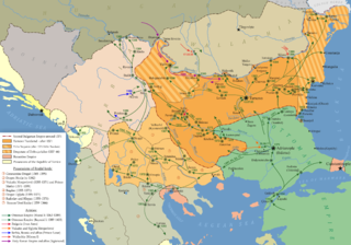
The history of Ottoman Bulgaria spans nearly 500 years, beginning in the late 14th century, with the Ottoman conquest of smaller kingdoms from the disintegrating Second Bulgarian Empire. In the late 19th century, Bulgaria was liberated from the Ottoman Empire, and by the early 20th century it was declared independent.

Elassona is a town and a municipality in the Larissa regional unit in Greece. During antiquity Elassona was called Oloosson (Ὀλοοσσών) and was a town of the Perrhaebi tribe. It is situated at the foot of Mount Olympus. Elassona is bypassed by the GR-3.

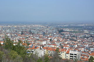
Giannitsa is the largest city in the regional unit of Pella and the capital of the Pella municipality, in the region of Central Macedonia in northern Greece.

Yenidze is a former cigarette factory building in Dresden, Saxony, Germany built between 1907 and 1909. Today it is used as an office building. It is notable for its Moorish Revival exterior design which borrows design elements from mosques and the Alhambra in Spain.

Margariti is a village and a former municipality in Thesprotia, Epirus, Greece. Since the 2011 local government reform it is part of the municipality Igoumenitsa, of which it is a municipal unit. The municipal unit has an area of 149.223 km2. Population 1,931 (2021).

Nea Zichni is a municipality in the Serres regional unit, of Central Macedonia region, Greece. Population 8,267 (2021). Nea Zichni is also the name of the administrative seat of the municipality, population 1,547 (2021).
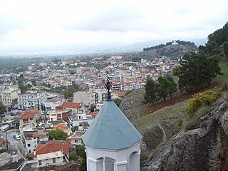
Sidirokastro is a town and a former municipality in the Serres regional unit, Greece. Since the 2011 local government reform it is part of the municipality Sintiki, of which it is the seat and a municipal unit. It is built near the fertile valley of the river Strymonas, on the bank of the Krousovitis River. Sidirokastro is situated on the European route E79 and the main road from northern Greece (Thessaloniki) to Bulgaria. It has a number of tourist sights, such as the medieval stone castle, Byzantine ruins, and natural spas.

Domokos, the ancient Thaumacus or Thaumace, is a town and a municipality in Phthiotis, Greece. The town Domokos is the seat of the municipality of Domokos and of the former Domokos Province. The town is built on a mountain slope overlooking the plain of Thessaly, 38 km from the city of Lamia.

Demir Hisar is a small town in North Macedonia. It is the seat of Demir Hisar Municipality.
Veria, officially transliterated Veroia, historically also spelled Beroea or Berea, is a city in Central Macedonia, in the geographic region of Macedonia, northern Greece, capital of the regional unit of Imathia. It is located 511 kilometres north-northwest of the capital Athens and 73 km (45 mi) west-southwest of Thessaloniki.

Tirilye is a neighbourhood of the municipality and district of Mudanya, Bursa Province, Turkey. Its population is 1,409 (2022). With the 2013 Turkish local government reorganisation, its town (belde) status and its municipality (belediye) were abolished, and it was made a neighbourhood (mahalle). It is situated 12 km (7.46 mi) west of Mudanya along the Marmara seashore. The area, which was inhabited since the eighth century BC, was formerly known as Τρίγλεια, Trigleia or Βρύλλειον, Brylleion in Greek. The most important historical structure in Tirilye (Triglia) is that of the Byzantine Haghios Stefanos Church, known today as the Fatih Mosque. Mudanya, a residential and commercial development in this township is under state protection as a historical site.

Sirkovo is a village in the municipality of Rosoman, North Macedonia.

Faik Pasha Mosque, also known locally as the Imaret of Arta, is a historical Ottoman building located in the town of Arta, Epirus, in Greece. Named after the Ottoman conqueror of the city in 1449, the mosque formed a complex including baths, an imaret and a madrasa. It is one of the two surviving mosques in Arta, the other being the Feyzullah Mosque. It is under renovation works and is not currently open for worship.
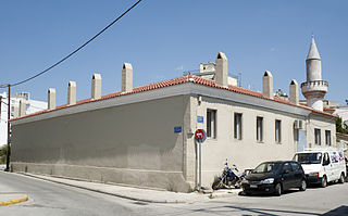
The Hayriyye Madrasa also commonly known as the Madrasa of Komotini is a madrasa turned minority school in the town of Komotini, in the Western Thrace region of Greece. It includes the complex of the Ottoman Kayali Madrasa and some newer buildings in the public market, where the Softalar Madrasa once stood.