
The administrative units of Pakistan refers to the subnational administrative divisions that play a role in the governance of Pakistan. The country is composed of four provinces and one federal territory: the provinces of Balochistan, Punjab, Sindh, Khyber Pakhtunkhwa, and the federally-administered Islamabad Capital Territory. Additionally, Pakistan also administers two autonomous territories in the disputed region of Kashmir: Gilgit-Baltistan and Azad Jammu and Kashmir. Due to the ongoing Kashmir dispute with neighbouring India, it also claims sovereignty over the union territories of Ladakh and Jammu and Kashmir, but has not exercised administrative authority over either region since its independence and subsequent war with India in 1947–1948. All of Pakistan's provinces and territories are subdivided into divisions, which are further subdivided into districts, and then tehsils, which are again further subdivided into union councils.
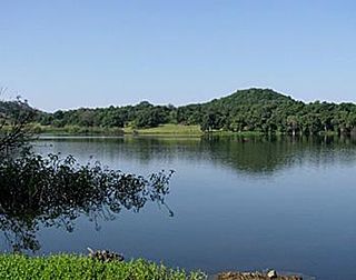
Nandurbar district is an administrative district in the northwest corner of Maharashtra state in India. On 1 July 1998 Dhule was bifurcated as two separate districts now known as Dhule and Nandurbar. Nandurbar is a tribal-dominated district, The district headquarters are located at Nandurbar city. The district occupies an area of 5955 km2 and has a population of 1,648,295 of which 16.71% were urban.

Roorkee (Rūṛkī) is a city in North India and a municipal corporation in the Haridwar district of the state of Uttarakhand, India. It is spread over a flat terrain under Sivalik Hills of Himalayas. The city is developed on the banks of Ganges Canal, its dominant feature, which flows from north–south through middle of the city. Roorkee is home to Asia's first engineering college Indian Institute of Technology Roorkee, formerly known as Thomson College of Civil Engineering. Roorkee is also known for the Roorkee Cantonment, one of the country's oldest military establishments and the headquarters of Bengal Engineer Group since 1853. Roorkee has the distinction of being one of the endpoints of the first train journey in India on 22 December 1851.

Banswara is a city in Banswara District in south Rajasthan in India. It is named for King Bansiya Bhil or the "bans" or bamboo forests in the area.

Doda is a district in the eastern part of Jammu Division in the Indian union territory of Jammu and Kashmir. The district consists of 18 tehsils viz. Thathri, Bhaderwah, Doda, Mahalla, Bhagwa, Assar, Bhalla, Gundna, Marmat, Kahara, Gandoh (Bhalessa), Bhella, Bharth Bagla, Chiralla, Chilly Pingal, Phagsoo and Kashtigarh.

Pilibhit district is one of the 75 districts in the state of Uttar Pradesh in India, and Pilibhit city is the district headquarters. Pilibhit district is a part of Bareilly Division. A Tiger Reserve Area was named Pilibhit Tiger Reserve in September 2008.
Didihat is a town and a Nagar Palika in Pithoragarh District in the state of Uttarakhand, India. It is one of the eleven administrative subdivisions of Pithoragarh district and also serves as its administrative headquarter. With a population of 6522, Didihat is located at a distance of 415 km (258 mi) from the state capital Dehradun.
Unnao district is a district of Uttar Pradesh state in northern India. The city of Unnao is the district headquarters. The district is part of Lucknow Division.
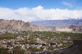
Leh district is a district in the union territory of Ladakh, a territory administered as part of India. With an area of 45,110 km2, it is the second largest district in the country smaller only to Kutch. It is bounded on the north by Gilgit-Baltistan's Kharmang and Ghanche districts and Xinjiang's Kashgar Prefecture and Hotan Prefecture linked via the historic Karakoram Pass. It has Aksai Chin and Tibet are to the east, Kargil district to the west, and Lahul and Spiti to the south. The district headquarters is in Leh. It lies between 32 to 36 degree north latitude and 75 to 80 degree east longitude.

Torghar District, Hindko: کالا ڈهاکه, English Black Mountain formerly also known as Kala Dhaka is the smallest district in Pakistan of Hazara Division in Khyber Pakhtunkhwa province. It was officially separated from Mansehra District in 2011 under Article 246 of the Constitution of the Islamic Republic of Pakistan. According to the 1998 census, the Mansehra subdivision then known as Kala Dhaka had a population of 174,700, of which 96% had Pashto as their first language.

Khandeshi is an Indo-Aryan language in the Maharashtra state of India. It is spoken in the Khandesh region, wedged between the territory of Bhili and that of Marathi. It consists of Khandeshi proper, and the Dangri and Ahirani dialects. The words "Ahirani" and "Khandeshi" are sometimes used interchangeably: Ahirani as the caste-based name, and Khandesh as the region-based name.

Bhitarwar is a city and a Municipality in Gwalior district in the state of Madhya Pradesh, India. The town is surrounded by a river called Parbati.

Dhadgaon is a municipal council in Nandurbar district, Maharashtra, India. The name Akrani is derived from a local queen "Akka Rani", Rani meaning queen in Marathi. Nandurbar district has five more tehsils viz. Akkalkuwa, Taloda, Shahada, Nandurbar and Navapur. The tehsil is surrounded by Madhya Pradesh state on north and east, Shahada and Talode tehsils on south and Akkalkuwa on west. Maharashtra State Highway 1 (MSH-1) passes through the tehsil along with Akkalkuwa and Shahada. The hill station and tourist attraction Toranmal is located in this tehsil.
Bhoksa, also known as Buksa, are indigenous peoples living mainly in the Indian states of Uttarakhand and Uttar Pradesh. They are mostly concentrated in Dehradun and Nainital districts in the foothills of the outer Himalayas. They are also found in the Bijnor district of Uttar Pradesh, where they are known as Mehra. Both communities have been granted Scheduled Tribe status.

Kishtwar district is a district of the Indian union territory of Jammu and Kashmir. As of 2011, it is the largest and least populous district of Jammu and Kashmir. It is situated on the banks of the Chenab River.

Pratapgarh district is the 33rd district of Rajasthan, created on 26 January 2008. It is a part of Udaipur Division and has been carved out from the erstwhile tehsils of Chittorgarh, Udaipur and Banswara districts. Pratapgarh town is the administrative headquarters of the district.

In India, a community development block is a rural area administratively earmarked for planning and development. The area is administered by a Block Development Officer, supported by several technical specialists and village-level workers. A community development block covers several gram panchayats, the local administrative units at the village level.
Kandia Subdivision consists of five Union Councils, i.e Karang, Thoti, Kareen, Jashoi and Gabrial in Kohistan Upper Khyberpakhtunkhawa in Pakistan having a population of approximately 84,055 according to Census 2017. The Detail of Union Councils is that Karang has four Villages, i.e Village council Dansh, village council Karang Khas, village council Berti and village council Bagroo. Union council Garial has six villages, i.e Nakao, mirshahi, mulakhel Gabrial, Shadomkhel Gabrial, Village bagh seri and village council Barigo. Union council Kareen has two villages, i.e village council Kareen and Village council Sergarhi. Union council Jashoi has three villages, i.e Dong, Siyal Dara and Jashoi. Union council Thoti has four villages, i.e Kafarbanda, Eleel, Serto and Thoti. There are many tourist points in Thoti Union council also.

Bachaura is a village in Pindra Tehsil of Varanasi district in the Indian state of Uttar Pradesh. The village falls under gram panchayat by the same name as the village. The village is about 34 kilometers North-West of Varanasi city, 273 kilometers South-East of state capital Lucknow and 794 kilometers South-East of the national capital Delhi.
Aadiwasi Janjagruti is an initiative by Ulgulan for Social Change Foundation which is working on creating social awareness and raising local issues in Dhadgaon block of Nandurbar Maharashtra through mobile video films It allows tribal people to highlight their issues in Pawari, Bhilori and Aahrani language by using citizen Journalism. Initially started in Dhadgaon block of Nandurbar districts it now covers news and local issues of entire districts.
