
Nandurbar district is an administrative district in the northwest corner of Maharashtra state in India. On 1 July 1998 Dhule was bifurcated as two separate districts now known as Dhule and Nandurbar. Nandurbar is a tribal-dominated district, The district headquarters are located at Nandurbar city. The district occupies an area of 5,955 square kilometres (2,299 sq mi) and has a population of 1,648,295 of which 16.71% were urban.

Shahada is a town in Nandurbar district of the Indian state of Maharashtra. It is a Municipal council. It is the second biggest town and the biggest Tehsil in Nandurbar district
Nandurbar is a city and a municipal council in Nandurbar district in the Indian state of Maharashtra. Nandurbar municipal corporation is the first municipal corporation. The District Nandurbar was formed from the district Dhule on July 1, 1998. Nandurbar is an administrative district in the northwest corner of of Maharashtra. On 1 July 1998 Dhule was bifurcated as two separate districts now known as Dhule and Nandurbar. The district headquarters is located at Nandurbar city. The district occupies an area of 5034 km2 and has a population of 1,311,709 of which 15.45% is urban. Nandurbar district is bounded to the south and south-east by Dhule district, to the west and north is the state of Gujarat, to the north and north-east is the state of Madhya Pradesh. The northern boundary of the district is defined by the great Narmada river. It came into limelight during February 2006 bird flu crisis which struck many of its poultry farms. Thousand of chickens from the farms had to be killed and buried in nearby grounds to stop the virus spreading.
Kalamb is one of eight tehsils in the Osmanabad district in the state of Maharashtra, India. Headquarters for the tehsil is the town of Kalamb. There are ninety-one panchayat villages in the Kalamb Tehsil.
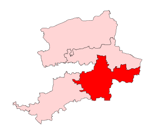
Nandurbar Assembly constituency is one of the 288 Vidhan Sabha constituencies of Maharashtra state in western India. This constituency is located in Nandurbar district and it is reserved for the candidates belonging to the Scheduled Tribes. It is currently held by Vijaykumar Gavit of the BJP.

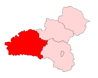
Akkalkuwa Assembly constituency is one of the 288 Vidhan Sabha constituencies of Maharashtra state in western India. This constituency is located in Nandurbar district and it is reserved for the candidates belonging to the Scheduled Tribes.

Navapur is one of the 288 Vidhan Sabha constituencies of Maharashtra state in western India. This constituency is located in Nandurbar district and it is reserved for the candidates belonging to the Scheduled Tribes.

Shahada Assembly constituency is one of the 288 Vidhan Sabha constituencies of Maharashtra state in western India. This constituency is located in Nandurbar district and is reserved for the candidates belonging to the Scheduled Tribes.
Sakri Assembly constituency is one of the 288 Vidhan Sabha constituencies of Maharashtra state in western India. This constituency is located in Dhule district and it is reserved for the candidates belonging to the Scheduled Tribes.

Shirpur Assembly constituency is one of the 288 Vidhan Sabha constituencies of Maharashtra state in western India. This constituency is located in Dhule district and is currently reserved for candidates belonging to the Scheduled Tribes.
Chinchpada is a panchayat village located in Nashik division of the Kandesh region of Maharashtra state in India. The village used to be called Bodhgaon. Administratively, Chinchpada is under Navapur Taluka, Nandurbar District, Maharashtra. There is only the single village of Chinchpada in the Chinchpada gram panchayat. It is located on National Highway 6, running from Hazira in Gujarat to Kolkota, West Bengal. It is about 100 km from Dhule and about 120 km from Surat.
Nizar (Nijhar) is one of the 7 tehsils in Tapi district in the Indian state of Gujarat. Nizar was separated from Surat district in 2007 while Tapi district was formed. Nizar is located in South Gujarat, about 172 km from Surat bordering Nandurbar district of Maharashtra. The official language is Gujarati.
Lohara Tehsil is a tehsil/taluka (subdistrict) in Osmanabad district, Maharashtra on the Deccan Plateau of India. Lohara Bk. is the administrative headquarters of the tehsil. There are forty-seven villages in Lohara Taluka.
Bhoom Tahsil is a tehsil in Osmanabad district, Maharashtra on the Deccan Plateau of India. The town of Bhoom is the administrative headquarters of the tahsil. There are seventy-four panchayat villages in Bhoom Tahsil. In 19th century Bhoom was under Nizam territory during the British raj in India. However it was independently ruled by the Thorat royal family. Shrimant Vijaysinh Amarsinh Thorat is the present head of Bhoom. He was the President of Bhoom Municipal Council from 1991 -2006.
Umarga (Omerga) Tehsil is a tehsil/ taluka/ subdistrict in Osmanabad district, Maharashtra on the Deccan Plateau of India. The town of Umarga is the administrative headquarters of the tehsil. There are 79 panchayat villages in Umarga Tehsil.
Lohara Bk. is a Nagar Panchayat town in the state of Maharashtra, India. Lohara Bk. is headquarters for and administratively under Lohara Tehsil of Osmanabad District in Maharashtra. There is only the single town of Lohara Bk. in the Lohara Bk. Nagar panchayat. The village of Lohara Bk. is 22 km by road west of the village of Sastur and 33 km by road east of the town of Tuljapur.
Sastur is a panchayat village in the state of Maharashtra, India. Administratively, Sastur is under Lohara Tehsil of Osmanabad District in Maharashtra. There is only the single village of Sastur in the Sastur gram panchayat. The village of Sastur is 20 km by road northwest of the village of Madaj and 22 km by road east of the village of Lohara Bk.
Madaj is a panchayat village in the state of Maharashtra, India. Administratively, Madaj is under Umarga Tehsil of Osmanabad District in Maharashtra. There is only the single village of Madaj in the Madaj gram panchayat. The village of Madaj is 17 km by road north of the town of Umarga and 20 km by road southeast of the village of Sastur.
Kasare, is a small village in Nandurbar District of Maharashtra, India. Administratively, Kasare is under Shehi gram panchayat, Navapur Taluka of Nandurbar District in Maharashtra. This village is located 2.5 km by road southeast of the village of Shehi, and State Highway 9.
The Pawara tribe lives in the Satpura hills of Maharashtra, India, and has been there for generations. They are found in the Dhadgaon, Shahada, Taloda, and Akkalkuwa Tahasils of Nandurbar district, and in the Jalgaon district. The Pawara tribe has different customs, social structure, and language than other tribes, and their economic activities are dependent on the Satpura mountains. The social administration of the tribe is controlled by the head of the village society The Pawaras or Pavaras are a subtribe of the Bhils found in satpuda pradesh also called Pávra Bhils, Pávra Náiks and Pávra Kolis. They hold three main festivals: Indiraja, Girhon mata and Shimga or Holi.
