
The Satpura Range is a range of hills in central India. The range rises in eastern Gujarat running east through the border of Maharashtra and Madhya Pradesh and ends in Chhattisgarh. The range parallels the Vindhya Range to the north, and these two east-west ranges divide Indian Subcontinent into the Indo-Gangetic plain of northern India and the Deccan Plateau of the south. The Narmada River originates from north-eastern end of Satpura in Amarkantak, and runs in the depression between the Satpura and Vindhya ranges, draining the northern slope of the Satpura range, running west towards the Arabian Sea. The Tapti River originates in the eastern-central part of Satpura, crossing the range in the center and running west at the range's southern slopes before meeting the Arabian Sea at Surat, draining the central and southern slopes of the range. Multai, the place of Tapi river origin is located about 465 kilometer far, south-westerly to Amarkantak, separated across by the hill range. The Godavari River and its tributaries drain the Deccan plateau, which lies south of the range, and the Mahanadi River drains the easternmost portion of the range. The Godavari and Mahanadi rivers flow into the Bay of Bengal. At its eastern end, the Satpura range meets the hills of the Chotanagpur Plateau. The Satpura Range is a horst mountain and is flanked by Narmada Graben in the north and much smaller but parallel Tapi Graben in the south.

Nandurbar district is an administrative district in the northwest corner of Maharashtra state in India. On 1 July 1998 Dhule was bifurcated as two separate districts now known as Dhule and Nandurbar. Nandurbar is a tribal-dominated district, The district headquarters are located at Nandurbar city. The district occupies an area of 5955 km2 and has a population of 1,648,295 of which 16.71% were urban.

Shahādā is a town in Nandurbar district of the Indian state of Maharashtra. It is a Municipal council.
Navapur is a nagar panchayat (municipality) and headquarters for Navapur Taluka in Nandurbar district, in the state of Maharashtra, India.
Bilimora is a city situated on the banks of the river Ambika, in Gandevi taluka & Navsari district of Gujarat state, in India. The city comes under the purview of the Surat Metropolitan Region. The city is roughly 70 kilometres (43 mi) south of the city of Surat and is the southernmost point of the Surat Metropolitan Region and the Metropolis of Surat. It is linked to Surat by SH 6 and SH 88.
Nandurbarpronunciation (help·info) is a city and a municipal council in Nandurbar district in the Indian state of Maharashtra. Nandurbar municipal corporation is the first municipal corporation. Nandurbar is an administrative district in the northwest corner of of Maharashtra. On 1 July 1998 Dhule was bifurcated as two separate districts now known as Dhule and Nandurbar. The district headquarters is located at Nandurbar city. The district occupies an area of 5034 km2 and has a population of 1,311,709 of which 15.45% is urban. Nandurbar district is bounded to the south and south-east by Dhule district, to the west and north is the state of Gujarat, to the north and north-east is the state of Madhya Pradesh. The northern boundary of the district is defined by the great Narmada river. It came into limelight during February 2006 bird flu crisis which struck many of its poultry farms. Thousand of chickens from the farms had to be killed and buried in nearby grounds to stop the virus spreading.
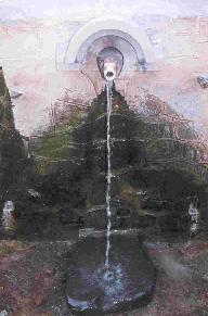
Unapdev is in Shahada, Dist. Nandurbar, Maharashtra tahsil located near the village Dara. It has a permanent natural hot water source.
Dhadgaon is a municipal council in Nandurbar district, Maharashtra, India. The name Akrani is derived from a local queen "Akka Rani", Rani meaning queen in Marathi. Nandurbar district has five more tehsils viz. Akkalkuwa, Taloda, Shahada, Nandurbar and Navapur. The tehsil is surrounded by Madhya Pradesh state on north and east, Shahada and Talode tehsils on south and Akkalkuwa on west. Maharashtra State Highway 1 (MSH-1) passes through the tehsil along with Akkalkuwa and Shahada. The hill station and tourist attraction Toranmal is located in this tehsil.

Maharashtra attracts tourists from other Indian states and foreign countries. It was the second most visited Indian state by foreigners and fourth most visited state by domestic tourists in the country in 2014. Aurangabad is the tourism capital of Maharashtra.
Sarangkheda is a village in Shahada taluka in Nandurbar district of Maharashtra state in India. Sarangkheda village is situated around 15 km South of Shahada on the bank of Tapti River.
Nandurbar Assembly constituency is one of the 288 Vidhan Sabha constituencies of Maharashtra state in western India. This constituency is located in the Nandurbar district and it is reserved for the candidates belonging to the Scheduled tribes. It is currently held by Vijaykumar Gavit of the BJP, who is former State Minister for Medical Education and Horticulture.
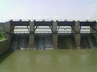
Susri Dam, also known as Mahavir Bandhara, is located around 7 kilometres (4.3 mi) north of Shahada, Nandurbar district in the state of Maharashtra, India. Susri Dam is a Diversion dam.
Savalde is a village in Shahada taluka in Nandurbar district of Maharashtra state in India. Savalde village is situated around 5 km South-west of Shahada, situated on the bank of river Tapti(Tapi) and on state border of states of Maharashtra and Gujarat.
Maharashtra Major State Highway 1, commonly referred to as MH MSH 1, is a major state highway that runs south through Dhule and Nandurbar districts in the state of Maharashtra. This state highway touches numerous cities and villages, namely Songir, Chimthane, Dondaicha, Nimgul, Shahada, Dhadgaon, Kathi, Molgi, Wadifali and then proceeds south-west towards Maharashtra-Gujarat state border. This highway enters Gujarat State near Wadifali village which is on border of Nandurbar district of Maharashtra and Narmada district of Gujarat and ends at Dumkhal village which is just 15 km South-East of Sardar Sarovar Dam.
Navapur Assembly constituency is one of the 288 Vidhan Sabha constituencies of Maharashtra state in western India. This constituency is located in the Nandurbar district and it is reserved for the candidates belonging to the Scheduled tribes.
Kukarmunda is one of seven Tehsils of Tapi district in South Gujarat. Originally Kukarmunda was a village and its tehsil Nizar but when the government separated Tapi district from Surat in the year 2007, Kukarmunda became a tehsil. The distance between Kukarmunda and Vyara is about 110 km and Surat is about 178 km. Kukarmunda shares a border with Akkalkuwa and Taloda tehsil of Nandurbar district of Maharashtra.Total area of Kukarmunda Town is 0.82 KM²
Nizar (Nijhar) is one of the 7 tehsils in Tapi district in the Indian state of Gujarat. Nizar was separated from Surat district in 2007 while Tapi district was formed. Nizar is located in the South Gujarat, about 172 km from Surat bordering Nandurbar district of Maharashtra.The official language is Gujarati.
Sagbara is a taluka in Narmada district, Gujarat, India. Its location is at NH-753B Ankleshwar-Valia-Netrang-Dediapada-Sagbara up to State Border to Akkalkuva in Maharashtra

Purna Wildlife Sanctuary is a wildlife sanctuary in the Western Ghats mountain range, in the States of Gujarat and Maharashtra, India. In the South Gujarat, it is located between Vyara, Tapi District and Ahwa, Dang District, and in Maharashtra, it is located in Nandurbar District. Apart from the Dangs' District, it is a part of the Northern Division of the Dangs' Forest.
Mahurgad Fort is a fort located 130 km (81 mi) from Nanded. The fort is in Mahur taluka in Nanded district, of Maharashtra. It is a pilgrimage centre of great significance to Hindus. It is the seat of goddess Renukadevi which is a shrine of shaktipeeth. The temple of goddess is situated 2 km from the village Mahur.

