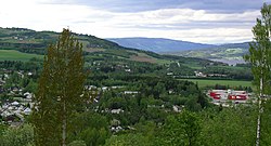
Lillehammer is a municipality in Innlandet county, Norway. It is located in the traditional district of Gudbrandsdal. The administrative centre of the municipality is the town of Lillehammer. Some of the more notable villages in the municipality include Fåberg, Hunderfossen, Jørstadmoen, Vingnes, and Vingrom.

Oppland is a former county in Norway which existed from 1781 until its dissolution on 1 January 2020. The old Oppland county bordered the counties of Trøndelag, Møre og Romsdal, Sogn og Fjordane, Buskerud, Akershus, Oslo and Hedmark. The county administration was located in the town of Lillehammer.

Gjøvik is a municipality in Innlandet county, Norway. It is located in the traditional district of Toten. The administrative centre of the municipality is the town of Gjøvik. Some of the villages in Gjøvik include Biri, Bybrua, and Hunndalen.

Hof is a village in Holmestrand Municipality in Vestfold county, Norway. The village is located about 14 kilometres (8.7 mi) northwest of the town of Holmestrand, about 10 kilometres (6.2 mi) southwest of the village of Sande i Vestfold, and about 8 kilometres (5.0 mi) south of the village of Eidsfoss. The smaller villages of Sundbyfoss and Hvittingfoss are both located a short distance south of Hof.

Follebu is a village in Gausdal Municipality in Innlandet county, Norway. The village is located along the river Gausa, about 3 kilometres (1.9 mi) to the southeast of the village of Segalstad bru. The town of Lillehammer lies about 15 kilometres (9.3 mi) to the southeast of Follebu.

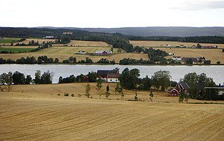
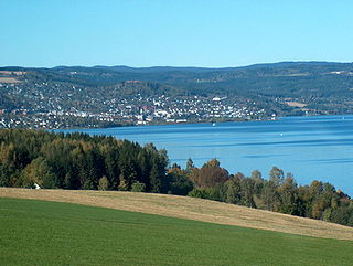
Mjøsa is Norway's largest lake, as well as one of the deepest lakes in Norway and in Europe. It is the fourth-deepest lake in Norway. It is located in the southern part of Norway, about 100 kilometres (62 mi) north of the city of Oslo. Its main tributary is the river Gudbrandsdalslågen flowing in from the north; the only distributary is the river Vorma in the south. Inflows would theoretically need 5.6 years to fill the lake. With an average depth of about 150 metres (490 ft), most of the lake's volume is under sea level. The average outflow of the lake (measured from 1931–1982) is 316 cubic metres per second (11,200 cu ft/s) which is about 9,959,000,000 cubic metres per year (1.1145×10¹⁰ cu ft/Ms). Mjøsa contains about 56.2 km3 (13.5 cu mi) of water compared to the 14.8 km3 (3.6 cu mi) in the lake Røssvatnet, the second largest lake by volume in Norway.

Lena is a village in Østre Toten Municipality in Innlandet county, Norway, about 5 kilometres (3.1 mi) to the southwest of the village of Kapp and lake Mjøsa. The 1.41-square-kilometre (350-acre) village has a population (2021) of 1,245 and a population density of 884 inhabitants per square kilometre (2,290/sq mi). The urban area of Lena also includes part of the village of Kraby, just to the east.

Skreia is a village in Østre Toten Municipality in Innlandet county, Norway. The village is located on the western shore of the large lake Mjøsa, about 7 kilometres (4.3 mi) southeast of the village of Lena and about 8 kilometres (5.0 mi) to the south of the village of Kapp. In the summers, there is a ferry from Skreia across the lake to the town of Hamar.

Kapp is a village in Østre Toten Municipality in Innlandet county, Norway. The village is located along the shore of the large lake Mjøsa, about 15 kilometres (9.3 mi) across the lake from the town of Hamar. The town of Gjøvik lies about 12 kilometres (7.5 mi) to the northwest of Kapp. Kapp has summer ferry connections to Gjøvik, Tingnes, and Hamar.

Nordlia is a village in Østre Toten Municipality in Innlandet county, Norway. The village is located on the shore of the lake Mjøsa, about 7 kilometres (4.3 mi) to the southeast of the town of Gjøvik, about 7 kilometres (4.3 mi) to the northwest of the village of Kapp, and about 9 kilometres (5.6 mi) north of the village of Lena. Nordlien Church is located in the village.

Slidre is the administrative centre of Vestre Slidre Municipality in Innlandet county, Norway. The village is located along the Slidrefjorden in the Valdres district. The village is located along the European route E16 highway, about 25 kilometres (16 mi) northwest of Fagernes.
Einavatnet is a lake which lies in Vestre Toten Municipality in Innlandet county, Norway. The 13.82-square-kilometre (5.34 sq mi) lake lies at an elevation of 398 metres (1,306 ft) above sea level. The lake lies in the southern portion of the municipality, about 12 kilometres (7.5 mi) south of the municipal centre, Raufoss. The village of Eina lies at the northern end of the lake. The Eina Church is located on the eastern shore of the lake. The Norwegian National Road 4 runs along the eastern shore of the lake. The river Hunnselva flows north out of the lake towards the town of Gjøvik where it drains into the large lake Mjøsa.
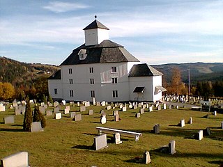
Nes is a former municipality in the old Hedmark county, Norway. The 177-square-kilometre (68 sq mi) municipality existed from 1838 until its dissolution in 1964 when it became part of Ringsaker Municipality. The administrative centre was the village of Tingnes where Nes Church is located. The largest village in Nes was Stavsjø where the Stavsjø Church is located. The municipality included the Nes peninsula and the island of Helgøya which both are surrounded by the large lake Mjøsa, Norway's largest lake.
Snertingdal is a former municipality in the old Oppland county, Norway. The 220-square-kilometre (85 sq mi) municipality existed from 1910 until its dissolution in 1964. The area is now part of Gjøvik Municipality in the traditional district of Vestoppland. The administrative centre was the village of Seegård.
Torpa is a former municipality in the old Oppland county, Norway. The 561-square-kilometre (217 sq mi) municipality existed from 1914 until its dissolution in 1962. The area is now part of Nordre Land Municipality. The administrative centre was the village at Åmot where the Åmot Church is located. Torpa currently constitutes the northern part of the Nordre Land, bordering the municipalities of Etnedal and Nord-Aurdal in the west, Gausdal, Lillehammer, and Gjøvik in the east.

Vardal is a former municipality in the old Oppland county, Norway. The 263-square-kilometre (102 sq mi) municipality existed from 1838 until its dissolution in 1964. The area is now divided between Gjøvik Municipality and Vestre Toten Municipality in the traditional district of Vestoppland. The administrative centre was the village of Vardal.
Gjøvik is a town in Gjøvik Municipality in Innlandet county, Norway. The town is the administrative centre of Gjøvik Municipality. It is located on the western shore of the large lake Mjøsa, about 45 kilometres (28 mi) south of the town of Lillehammer and about 20 kilometres (12 mi) west from the town of Hamar.

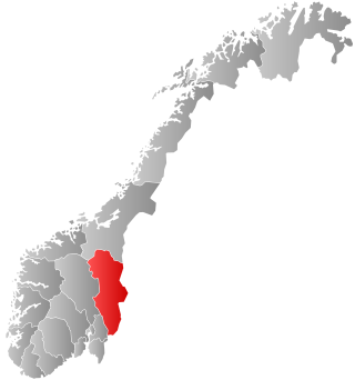
Innlandet is a county in Norway. It was created on 1 January 2020 with the merger of the old counties of Oppland and Hedmark. The new county has an area of 52,113 square kilometres (20,121 sq mi), making it the largest county in Norway after Troms og Finnmark was split up in 2024.

Fåberg is a village in Lillehammer Municipality in Innlandet county, Norway. The village is located in the Gudbrandsdalen valley, along the shore of the Gudbrandsdalslågen river. The town of Lillehammer lies about 5 kilometres (3.1 mi) to the southeast of Fåberg and the village of Jorstadmoen lies about 3 kilometres (1.9 mi) to the southwest of Fåberg. The European route E6 highway and the Dovrebanen railway line both run through the village. The historic Fåberg Church lies a short distance west of the village, on the other side of the river.

Biri is a former municipality in the old Oppland county, Norway. The 188-square-kilometre (73 sq mi) municipality existed from 1838 until its dissolution in 1964. The area is now part of Gjøvik Municipality in the traditional district of Vestoppland. The administrative centre was the village of Biri.